
|
|
Route |
|---|---|
|
|
48.24310°N / 120.6953°W |
|
|
Hike |
|
|
Most of a day |
|
|
Class 3- |
|
|
Overview
The majority of this route is cross-country in nature. There will be some routefinding around short cliffs but all in all this is a non-technical approach to the mountain. You will be crossing over one divide in the process. Don't let the name of the divide scare you: the Riddle-Enigma-Puzzle divide.
Devore Creek Trail
From 4,200-ft Bird Creek Camp (see the Main Page) there are two viable approaches to Flora. One option (the first) is more direct but will require a greater elevation loss into Castle Creek. Both shall be described. If you like loop trips, go to Flora via one option and go back to camp via the other.
Option 1: Enigma-Puzzle Saddle
From camp, continue up the trail for about 1.3 miles to 4,620 ft where West Fork Devore Creek comes down from the right. There is an open swath here (might be brushy). At either edge of the open area, descend to Devore Creek in trees. Once across the creek bear ESE to the open basin thence up to the 7,200-ft saddle between "Puzzle Peak" (Pk 7660) and "Enigma Peak" (Pk 8015). There are some short cliffs to contend with but a gully should be locatable to get up through these.
Now at the saddle you can take a direct bearing toward Flora (ESE), dropping 800 feet to Castle Creek in the process, or turn right (SSW) and scramble up Enigma's north ridge to about 7,400 ft (but no higher) to commence a long high traverse across Enigma's east slopes. I recommend the former. The 800-ft drop is worth it over the long sidehilling of the latter. Besides, even with the latter you'll have to descend to 6,800 ft anyway to drop down around obstacles--espcially those of the lower part of Pt. 7640+ at the head of Castle Creek.
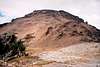
Essentially, aim for the high southwest basin of Flora. Once there, a simple talus scramble gets one to the summit.
Allow 4-5 hours from Bird Creek Camp (or even less if you're speedy). The total gain is about 4,800 ft.
 |  |
Option 2: Saddle South of Enigma
From camp, continue up the trail for 2.3 miles to 5,000 ft nearly to Fourth of July Basin. If you've hiked up to 5,200 ft you've gone too far with the potential of getting into the wrong basin once you leave the trail. At 5,000 ft, leave the trail, cross the creek, and bear ESE. If you find yourself hking cross-country into a narrow basin as early as 6,200 feet know that you are too far south. Contour northward immediately to round a corner below steeper terrain to get to the next basin over. Hike this correct basin to the 7460-ft divide on the south ridge of "Enigma Peak" (Pk 8015). This divide is approximately 1.5 miles from the Devore Creek Trail.
Descend 600 feet off the east side of the divide into Castle Creek. Contour around at 6,800 ft to avoid steeper, less pleasant terrain, then aim for the high southwest basin of Flora. Once there, a simple talus scramble gets one to the summit.
Allow 4.5-5.5 hours from Bird Creek Camp (or even less if you're speedy). The total gain is about 4,600 ft.
 |  |
Essential Gear
Ice axe in early season. In late season leave it at home. This area gets to be completely devoid of snow by late August.
A map and compass will also be handy.
In the height of the spring and summer season be prepared for thunderstorms.