
-
 3261 Hits
-
 71.06% Score
-
 1 Votes
|
|
Route |
|---|---|
|
|
41.18460°N / 3.4649°W |
|
|
Hike |
|
|
Half a day |
|
|
F |
|
|
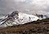
Approach
See "Getting There" in the MAIN PAGE to get the base of the climb, La Pinilla Ski Resort (1,500 m).
Route Description
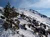
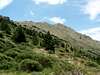
From the buildings of La Pinilla follow the trail forest (it starts near a reservoir) along some zigzags gaining 530 m over the ski resort up to Point 2,030 m. From this place, situated near the col between Cerro del Aventadero and Las Peñuelas, follow "From Puerto de la Quesera, Normal" route / "Route Description".
 |  |  |
Essential Gear
Crampons and ice axe could be necessary in some days from November-December to February-March. Also wear warm clothes and mask when blizzard. Do not forget your map and compass in that period. A water source is located near Point 2,030 m on the NW face of Las Peñuelas. But this drinking fountain could be dry in Summer so carry 1-1.5 liters of water a head.