
-
 10545 Hits
-
 86.85% Score
-
 23 Votes
|
|
Route |
|---|---|
|
|
48.77650°N / 113.72686°W |
|
|
Summer, Fall |
|
|
Most of a day |
|
|
strenuous off-trail hiking, with some Glacier NP Class II & III climbing |
|
|
Overview
Where's Mount Grinnell?
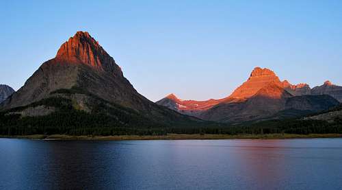
One of the more famous viewpoints in all of Glacier National Park is from the east shore of Swiftcurrent Lake, with the massive faces of Mount Gould (9,553 ft.) and Mount Wilbur (9,321 ft) bookending the magnificent alpine scene. Much like Sinopah Mountain in the Two Medicine Valley, smallish Grinnell Point (7,600 ft) commands the most attention, with its steep, craggy summit rising high above the lake and trees far below. People are often impressed to find out that its merely the easternmost high point along the long summit ridge of Mount Grinnell (8,851 ft), which despite rising over 1,200 feet higher than Grinnell Point, is completely hidden from view. It's unfortunate, because Mount Grinnell is truly an impressive peak, with a steep, jagged summit that beckons to be visited. This page will outline an approach from the east that involves a wonderful stretch of trail hiking, followed by a prolonged off-trail section that crosses beautiful high alpine meadows and an interesting glacier basin before culminating in a scenic walk up Mount Grinnell's western summit ridge.
Getting There
From the small, unincorporated town of Babb, MT, take the bumpy, pothole-ridden road the leads into the Many Glacier region of the park. The road terminates at a large parking area near the Swiftcurrent Motor Inn; the Swiftcurrent Pass Trail begins here, and will serve as the starting point for the eastern approach to Mount Grinnell.Route Description
Ascent

Red Rocks Falls in front of Mount Grinnell

Mount Grinnell's north face rises 4,000 feet above Bullhead Lake
The first two miles of the Swiftcurrent Pass Trail are extremely popular, as the trail is highly accessible, essentially flat, and provides fantastic views into the Swiftcurrent Valley. Many hikers on the trail will be setting out for Fishercap Lake (0.7 miles one-way) or Red Rock Falls (1.8 miles one-way) on short day hikes. Both are fantastic spots to see moose, with Fishercap Lake proving to be a highly reliable site to see the majestic beasts on a regular basis. After reaching Red Rock Falls, the amount of people on the trail will drop significantly.
A word of caution: the next 1.5 miles of trail between Red Rock Falls and Bullhead Lake is bordered by dense brush on both sides, and grizzly sightings are common in the area. In fact, the trail was closed for about a week in August of 2009 due to what park rangers described as a massive grizzly bear who did not appear to have much of a fear for humans. Make TONS of noise while on this stretch; spooking a big ol' surly male grizz is not the wisest way to start off your day! Views get better as the trail heads west, with the unbelievable east face of Mount Wilbur dominating the scene. You'll likely notice a well-worn climber's trail that leads uphill towards a drainage between Wilbur and Bullhead Point, but save that one for another day.
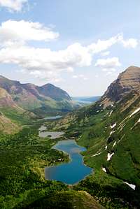
Swiftcurrent Valley

meadow north of Swiftcurrent Glacier Basin
After passing Bullhead Lake, the trail meanders through a stream bottom that will contain various amounts of melt water depending on the time of year. However, there are several small planks that provide safe and easy passage over the running water; no fording required here. Soon the trail begins to head uphill, and enters a notorious set of swtichbacks. You're now on one of the more difficult stretches of maintained trail hiking in the park. Plod uphill, enjoying the spectacular views that unfold as you climb higher up the trail. As the trail winds through marvelous fields of creamy white beargrass, a steep cirque containing numerous high waterfalls is visible to the south; these cascades all drain from Swiftcurrent Glacier, perched high above the rim of the cirque. After several switchbacks, the trail becomes quite narrow as it makes its way towards a large waterfall to the west. After skirting the edge of the waterfall, the trail heads back to the east between sheer cliffbands towards a large curve referred to as the "Devil's Elbow". From the Elbow, views back down the Swiftcurrent Valley are exquisite, with several lakes and the historic Many Glacier Hotel in full view. Continuing uphill, a swift creek that drains Swiftcurrent Pass is crossed, and the trail switchbacks yet again, this time trending uphill to the west. Soon a lush meadow is reached, and the creek is once more crossed. From this point, Swiftcurrent Pass is about 1/2 mile away.
Head uphill, and after about 100 feet, look for a game trail that leads through a break in the trees to the hiker's left. Follow the game trail, and within a minute a large open area with sparse vegetation is reached. A large, rocky hump is visible to the west; head towards the hump and follow game trails up and over it. From here you'll find easy access to a broad gravel hillside that takes you downhill to the south. Nothing worse than class III should be encountered as you carefully make your way down the steep hillside.
The small creek in the valley below is actually the source for the large waterfall encountered just prior to the "Devil's Elbow on the Swiftcurrent Pass Trail far below; follow it upstream, angling towards a beautiful grassy meadow off to the west. Wildflowers abound here, and eventually the creek will trend to the south. Continuing follow it, and before long you'll see a large lateral moraine that borders the northern edge of Swiftcurrent Glacier Basin. Either climb up and over the moraine, or divert around it to the left; either way provides easy access to the basin.

Take time to marvel at the various melt ponds and trickling cascades smattered about the long, smooth bands of rock at the glacier's terminus. Mount Grinnell's summit is clearly visible to the southeast; you'll ultimately want to climb up to top of the ridge that leads west from the summit. In order to access the ridge, scramble downhill to the eastern reaches of the glacier basin. The next stretch of climbing will ultimately prove to me the most arduous of the entire route. Head uphill, taking the most direct route up large talus towards the western summit ridge some 1,000 feet above. Resist the temptation to angle towards Mount Grinnell at this point; the sooner you gain the ridge, the sooner you'll be walking along the scenic and solid ridge. Once the ridge is gained, it's still several hundred feet uphill to the east towards the summit. Route finding is intuitive here, with class II scrambling all the way to the top of the crumbled summit block.
Summit Views

Descent
There are various descent routes from this point, all of which are described in detail by J. Gordon Edwards in his A Climber's Guide to Glacier National Park. I chose to return towards the Swiftcurrent Pass Trail, but rather than retrace the route across Swiftcurrent Glacier Basin, I opted to take a slightly different way back down through the cirque west of Bullhead Lake. Heading back through the glacier basin is probably a more enjoyable option, but I wanted to share this variation for those that are interested. Head west along the summit ridge, and after leaving the large boulders just shy of the summit, angle northwest, taking extra caution to avoid slips down large blocks of talus. You ultimately want to reach the low point of a drainage basin between Swiftcurrent Glacier and Mount Grinnell. After bottoming out in the basin, head north, where large cliffs will block further progress. Walk east along the top of the cliffs, and soon an obvious class III break will be reached, which can be easily down climbed. Traverse west along a broad scree and talus covered shelf, taking care to find safe places to cross the various streams that drain Swiftcurrent Glacier. Do not head downhill until you are well clear of the brush below, as it looks like bushwhacking hell, complete with hidden cliffs and loose rock. Once you are west of all the foliage, head straight downhill toward the large creek the drains towards Bullhead Lake. Once the creek bottom is reached, you'll be able to reunite with the Swiftcurrent Pass Trail, and it's an easy four miles back to the trailhead at the Swiftcurrent Motor Inn.
Essential Gear
J. Gordon Edwards' A Climber's Guide to Glacier National Park is an absolute necessity for anyone who wants to safely forary into Glacier's backcountry. His route descriptions are very detailed, and will almost always lead you in the right direction for exploring various peaks and off-trail destinations through the park.Bear spray is a must! As mentioned earlier in the route, the Swiftcurrent Valley is prime bear habitat. Make sure to be equipped with bear spray, know how to use it, and make plenty of noise while hiking.
Sturdy hike boots with solid ankle support will definitely come in handy on the talus slopes of Mount Grinnell. If you chose to venture on to Swiftcurrent Glacier, an ice axe and crampons would be quite helpful.
Rain gear, first-aid kit, map/compass, etc.