
-
 2883 Hits
-
 71.06% Score
-
 1 Votes
|
|
Route |
|---|---|
|
|
50.82230°N / 114.9611°W |
|
|
Mountaineering |
|
|
Summer |
|
|
Most of a day |
|
|
Difficult Scramble |
|
|
Approach
This is a 3900’+/- ascent day including regained lost elevation on the southeast ridge. Hike or bike, I prefer the bike, through the Little Elbow Campground as it dead ends into the Little Elbow Trail that runs along the Little Elbow River. This portion of the trail is basically a fire road and well suited for mountain bikes. After approximately 3.5 km you will come across the Nihahi Creek Trail on your right. Pull your bike into the bush at this intersection and ascend this trail via switchbacks until it dumps you onto a normally dry alluvial streambed that eventually branches out into gravel flats as the trail ends at 2.4 km. Mount Fullerton is on your left, Nihahi Ridge is on your right as the valley opens up. | 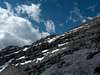 |  |  |
Route Description
Continue northwest down the open valley for approximately an hour. As the gravel flats fades out, it takes a sharp turn left exposing a narrow rocky drainage pouring out of the northwestern flank of Mount Fullerton. At first this ascent looks cumbersome and potentially hard on the feet, but once in it, you will notice perfect footing in terms of mossy and grassy areas being fed by snow drainage. After ascending this drainage approximately 1000’ as it curves south, ascend the grassy slope on your right to gain the rocky northwest ridge. If you are ascending from June on, you should run into at least one family of marmots in this area. Stay to the left of the rocky crest for some time as it intermittently breaks up. Eventually it makes sense to hop on top of the ridge for the final ascent to the summit. A few hands on problems are solved quickly on the way to the summit.There is a summit register and the summit views include Mount Glasgow and Mount Cornwall to the southeast, Mount Remus and Mount Romulus (both distinctive summits) to the south and Mount Fisher and Mount Bogart to the west. Nihahi Ridge separates Mount Fullerton from the Alberta foothills and plains as well as you can see Calgary to the northeast on a clear day. Now is also the time to take in the crux of the traverse route to the east if you chose to continue.
Take the time to scope out, from Mount Fullerton’s summit, another obvious summit point on the ridge to the east. There are going to be several problems to work out between these two high points. The ridge is separated by a very narrow gap that can be down climbed. The thrusts before that gap are best bypassed on the south. The thrusts after this gap are best bypassed on the snow covered ledges to the north. Several of these re-ascents to the ridge make up the crux of this traverse.
Proceed east from the summit and bypass the larger obstacles on the right (south) side to avoid being “stopped out” on the ridge. There will be at least one bypass on the north, but all is relatively obvious and easy going, although no trail exists. Eventually you will come to a narrow low point in the ridge. This step takes one move to downclimb to the col. Next, proceed to the second half of the ridge between the summit and eastern highpoint. When you come to several of these steep faces on the ridge, they are all bypassed on the left (north). I explored the vast ledge systems on the south, but they do not appear feasible for regaining the ridge. Each time you bypass a problem to the north, immediately scope out a return to the top of the ridge. Don’t get carried down to far on ledges. There will be snow if early season or even in July and it is imperative that you use rock hand holds to avoid fully trusting the snow beneath you. As soon as I found 5.5 climbing opportunities, I took them and regained the ridge each and every time until eventually all that was left was a short hike on scree to this eastern highpoint which is well cairned. The rock is extremely loose on the north side of this ridge, so beware if more than one climber.
Once at the eastern highpoint, you have options. Either you can continue along the ridge and descend through the trees to the northeast to regain the Nihahi Creek Trail or you can bail earlier on more open ground and scree. I chose to keep the ridge longer and descend through the trees. I used the Little Elbow River as my compass point when I hit the trees. The bush was not unbearable, but I did find some very steep cliffs that needed to be traversed to the east via an animal trail so I could find ground to descend back to the drainage. It is essential that if you are descending through the trees, you either descend northeast to the Nihahi Creek dry bed before it becomes a narrow canyon or commit to descending the southeast ridge directly south to Little Elbow Trail. Once back at the Nihahi Creek intersection with Little Elbow Trail, hop back on your faithful bike for the return.