
-
 11289 Hits
-
 79.78% Score
-
 11 Votes
|
|
Route |
|---|---|
|
|
46.65097°N / 11.77817°E |
|
|
Download GPX » View Route on Map |
|
|
Hiking, Via Ferrata |
|
|
Summer, Fall |
|
|
Most of a day |
|
|
Easy Via Ferrata |
|
|
Overview
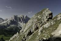
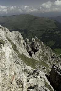
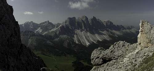 Geisler / Odle Group seen from one of the saddles of Günther Messner Höhenweg Geisler / Odle Group seen from one of the saddles of Günther Messner Höhenweg |
Reinhold and Günther Messner, who were born and grew up in the Valley of Vilnöß / Val di Funes, did their first climbs on the surrounding mountains, soon establishing themselves among the elite of the climbers of their day. Their routes through the west faces of Peitlerkofel, Furchetta or Heiligkreuzkofel are still counted among the most difficult routes of the area. After Günther died during the brothers' descent from Nanga Parbat the local authorities decided to honour him by naming a hiking route / via ferrata in his name.
Günther Messner Höhenweg / Alta Via Günther Messner follows the complete ridge of the Aferer Geisler / Odle di Eores, a second grade mountain range rising out of the midst of the two branched Villnöß Valley / Val di Funes. The ridge runs west to east and culminates in Tullen, with 2652m the highest summit of the range. A bit further to the east, separated from Aferer Geisler / Odle di Eores by Peitlerscharte stands one of the best lookout mountains of the Dolomites, Peitlekofel / Sas da Pütia (2874m). With good preparation both can be climbed within one long day, thus connecting Günther Messner Steig with the Peitlerkofel Ferrata.
Günther Messner Höhenweg / Alta Via Günther Messner has two branches, the one along the ridge, and the return or access route beneath the north faces of the group. Most climbers, however, use the shorter access from Zanser Alm to do a loop trail to the south of the group, which offers wonderful views of the rugged Geissler / Odle Group.
Rock quality on the route is very poor so that several of the protected sections have already collapsed beneath rockslides. In some cases new paths have been created and equipped with protection, in others you need to get along without. In any case: there is only little protection on the trail but the one that remains is in good shape. Scree slopes and couloirs pose the biggest dangers on the route.
Getting There
  |
Usually Günther Messner Höhenweg / Alta Via Günther Messner is done as a round trip from Zanser Alm / Malga Zannes at the end of Vilnöß / Val di Funes. Be prepared to pay a parking fee (€4 in 2012).
- Take the Brenner Motorway A22 to the exit Feldthurns / Valturno
- Go east on SP27 into Villnößtal /Val di Funes
- At the end of the road there are several parking lots at Zanser Alm / Malga Zannes
Route Description
 Wälscher Ring
Günther Messner Höhenweg / Alta Via Günther Messner can be hiked / climbed in both directions and the two via ferrata guidebooks I own describe either way. The description here is in counter-clockwise direction.
- Start altitude: 1650m
- Summit altitude: 2652m
- Prevailing exposure: N and S
- Type: Sentiero Attrezato K1
- Protection: Little protection, long hiking stretches
Approach
From the parking lots at Zanser Alm / Malga Zannes follow the signs to Gampenalm / Malga Gampen and Schlüterhütte / Rifugio Genova. There are marked trails on either side of the creek which later recombine. A few steps later you need to decide whether you want to take the longer approach along the road to Gampenalm / Malga Gampen or take the direct route along a steep footpath. The latter leads across the beautiful pastures beneath the Alm where you can enjoy first views of the Geisler / Odle Summits.
 |  |  |
You pass through between the Alm buildings where the next decision awaits you: a broad roundabout path or a rocky trail both head for Schlüterhütte / Rifugio Genova. The latter directly climbs the rock slopes beneath the hut while the former passes around them to head for the hut from behind. Either way you're soon at the hut with one of the best views in the area.
Now follow the signs to Peitlerkofel / Sas da Pütia. After a short ascent to Kreuzkofelscharte the path traverses the east slopes of the easternmost summits of the Aferer Geisler / Odle di Eores. Midway to Peitlerscharte Günther Messner Höhenweg / Alta Via Günther Messner turns off to the left.
The Ridge Traverse
 |
A short ascent towards the west takes you to a small ridge with a big view, which you can hike out southwards for 300m (exposed) to get a perfect overview over the Puez / Geisler Group. Turn back, heading north for 200m and you'll reach the Aferer Geisler ridge, which will accompany you for the next three hours. From Peitlerscharte another trail joins as you head westwards, passing the first summits to the north (good views of Peitlerkofel here). Quickly, however you'll reach a saddle across which you head for the shallower south side of the ridge. Here, at Ringspitze. the first protected section leads you through the south face of the summit, ending in a tall ladder which leads down into a saddle.
 |  | 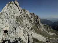 |
Now a traverse of the grassy south slopes of the Aferer Geisler follows, heading for the faraway summit of Wälscher Ring. Before you reach it you have to climb across several notches in the ridge, often losing elevation for some 100m before regaining it in the next notch. Every now and then you can catch a glimpse of the impressive north faces of the group. An unprotected scree gully leads you into a saddle right before Wälscher Ring, where the only difficult part of the trail starts.
 |  |  |
From the saddle the trail first loses ground before it steeply ascends towards the summit. It reaches the ridge several hundred metres before and crosses over descending the north face in a well protected section. A narrow path leads through the north face to the base of the summit. Here a very difficult ferrata section (alternative) leads to the summit across featureless slabs.
 |  |  |
The regular trail remains in the north face, passing Wälscher Ring but later heads back for the ridge. It is a steep climb through a scree filled gully heads for a small saddle where you are rewarded with a view back to mighty Peitlerkofel / Sas da Pütia above the Aferer north faces. Next you traverse a scree slope heading to the next gully. The protected section of this gully is on the right hand side while at the bottom broken equipment tells a story of frequent rockfall.
 |  |  |
Sidestepping to Tullen
Where the gully ends an unmarked path turns off to the right heading for the highest summit of the Aferer Geisler / Odle di Eores, Tullen. It is a shortcut on very insecure terrain. For security reasons you should stay on the main path, even though you'll lose som 50m of elevation. At a proper intersection, complete with signpost, the Tullen ascent route turns off to the left.
 |  |  |
While Tullen is not part of Günther Messner Höhenweg / Alta Via Günther Messner, at least on a fine day the ascent is mandatory. The mountain stands above its neighbours and is famous for its far reaching views. However, the most interesting aspect is the one of the huge towers of the Geisler / Odle Group right across Villnößtal / Val di Funes. The Tullen ascent is straightforward, though very brittle. It heads for a small saddle on the east ridge of the summit. The topmost part, just beneath this saddle, is protected with cables (which I wouldn't trust my weight on). The ridge itself is unprotected and thanks to the omnipresent scree not just a little scary. Descend the same route
The Little that Remains
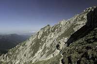
After Tullen the difficult parts of Günther Messner Höhenweg / Alta Via Günther Messner are over. What remains is a hike through a high valley underneath Weißlahnspitze / Cima Lavinia Bianca and Rüfen. To reach it you descend the scree slopes underneath the Tullen south face, then stroll along the valley. Make sure to step close to the summits and towers along the ridge to enjoy the fast dropping views down some of the guullies in the north face.
 |  |  |
After Weißlahnspitze has been passed, the trail turns southwards quickly losing elevation. After a while you'll reach an intersection: Oberer Herrensteig one of the very popular and scenic panorama trails leads by. To the right (west) it finally leads down to the Würzjoch Road to the left (east) it leads to Zanser Alm / Malga Zannes.
The Descent
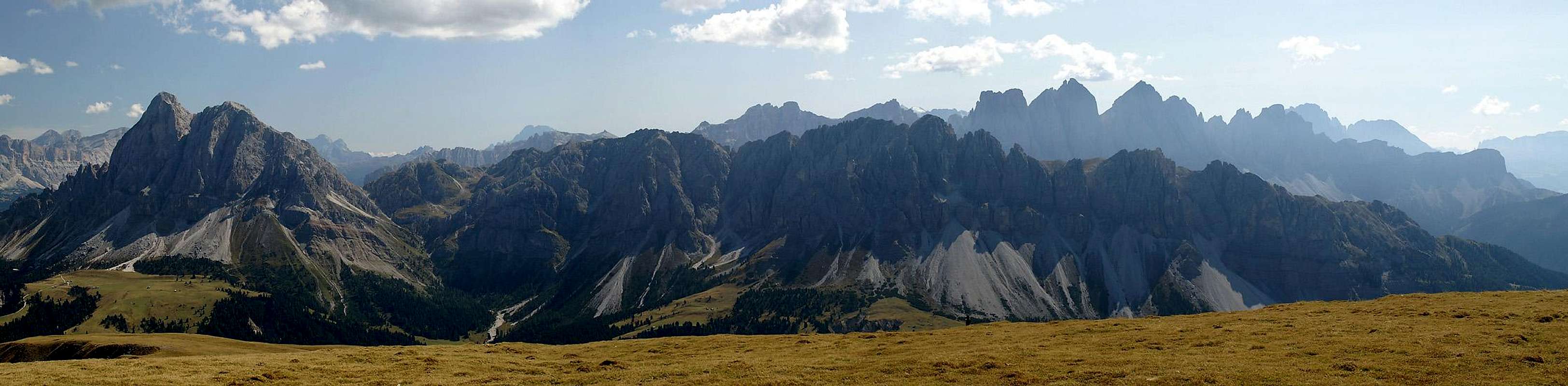
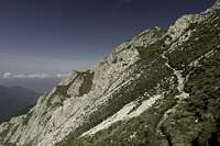
 Aferer Gesler / Odle di Eores south slopes
Oberer Herrensteig follows the Aferer Geisler south slopes, mainly ramaining above the treeline. Beneath is its little brother Unterer Herrensteig which heads through the canopy and only occasionally offers views across the valley. There are several steep interconnecting trails so that there are plenty of options. The one which worked for me was as follows:
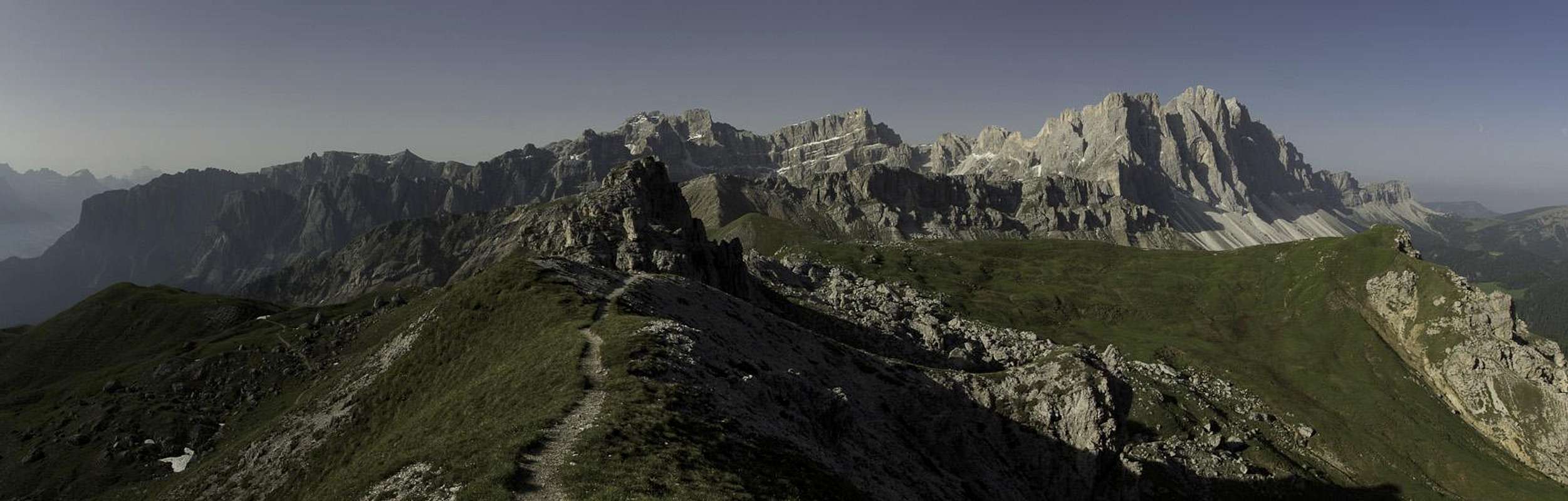
 Last view of the Geisler / Odle Group before plunging beneath the trees
You take Oberer Herrensteig eastward until it has dropped far enough to touch upon the trees on the slopes. Here, after a short while a path joins from the west. Turn westward on this trail, which more or less keeps level. At the first signpost follow the signs to Zanser Alm / Malga Zannes onto a steep path which winds down the slopes almost directly. It is a long descent of some 700m elevation loss but it will end about 300m from the toll booth of the Zanser Alm parking lot. (There is another descending path a bit further to the east which will end at the parking lot directly but I wasn't able to find it).