
|
|
Mountain/Rock |
|---|---|
|
|
46.22046°N / 8.01624°E |
|
|
Wallis |
|
|
Hiking, Skiing |
|
|
Spring, Summer, Fall, Winter |
|
|
9177 ft / 2797 m |
|
|
Overview
The eastern dorsal of Pennine Alps range, after the impressive ridge and glaciers of mount Weissmies(4023m), descends more gently to the famous Simplon pass with a series of nice summits whose approach is quick and easy due to the presence of the near highway SS33.The highest of these mountains is Galehorn, the first peak not covered by ice at north of Weissmies.
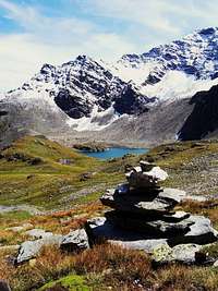
Galehorn is often visited, both in summer and in Winter, thanks to the pleasant and quick normal route that from the locality called Chusmatte reaches the wide summit where the view embraces the spectacular range of Monte Leone, the South flanks of the Berner Alpen range with the huge Aletch Glacier (the biggest ice field of the Alps) and the North faces of Fletschorn and Weisshorn.
 Galehorn in Winter from Chusmatte
Views.
 |  |  |  |  |
Getting There
The starting point is a car park at the side of the Simplon road, near Engliloch, in the parking of the locality called Chusmatte, only a few kilometers at north of Simplon Dorf, the main village on the southern side of Simplon pass.This area is easy reachable from Italy following the Milano – Gravellona Toce highway and then continuing in the direction of Simplon pass (SS33).
From Switzerland it’s less than an hour of car from Brig across the Simplon pass.
There is also a bus service that covers all the main Road of Simplon, from Brig to Simplon Dorf.
The elevation gain from Engliloch to the summit is of 1000 meters.
No huts are located in this area but the route isn’t long.
Routes: Hiking and Ski-mountaineering
Normal route: | From the parking near Engliloch start hiking towards West, following the well signed trail that crosses the lovely meadows above Chusmatte in the direction of an huge water fall that carves the cliffy wall between Galehorn and Boshorn. You gain the summit of this cliff by a steep path equiped with a fixed chain, there are no technical difficulties nor exposed passages. Continue toward West passing near the biggest lake of Sirwolte, located 100 meters on the left of the trail under the impressive north face of Hubschorn, when you pass by two other small lakes start to scramble to reach the E-SE ridge, where you find a good path that leads to the summit. There are other routes that ascends to the top more directly from East, but this is the most pleasant and the most secure, especially if you are ski-mountaineering. |
From the summit it’s possible to descend towards Nord(not skiing) following the steep North ridge (some passages of I, UIAA) and then reach directly Simplon pass, in this way you can realize the complete crossing of the mountain, the North ridge can also be used to climb to the summit with a smaller elevation gain.
Over the steep East face there is a pair of paths that can be used for a more direct approach to the summit, this face can also be discended skiing, but avoid these slopes in the days immediately after massive snow falls.

External Links
 | http://www.nelcuoredellealpi.com/Svizzera/Sempione/30.07.2006%20Galehorn/Galehorn.html Trip report with nice images and detailed description in Italian. http://www.cappef.com/le%20valli/sempione/galehorn3.htm Report of a ski-mountaineering ascent with photos and maps. |
 Galehorn from the trailhead at Chusmatte in late summer