
|
|
Canyon |
|---|---|
|
|
42.59353°N / 0.14420°E |
|
|
Hiking, Trad Climbing, Mixed, Scrambling, Canyoneering |
|
|
Spring, Summer, Fall, Winter |
|
|
Overview
About spannish Pyrenee's Canyons The gorges
Monte Perdido is the oldest National park in Spain, and one of the Pyrenees most gorgeous and original place. This is the biggest and tallest limestone mountain in the whole Europe.

But it is not its only feature. Monte Perdido is dug on all sides by several gorgeous Canyons. On the french side they are 3 and called "Cirques" rather than "Canyons" (the most famous being the Cirque de Gavarnie, together with the Cirque d'Estaubé and the Cirque de Troumousse.
On the Spannish side they are also at least 4, and here they truely deserve the name "Canyon". The 2 most famous are of course Ordesa (west) and Añisclo (south), both amongst Europe's largest and deepests canyons. But they are not the only ones.
The less known Escuaín gorges complete the club.
 Escuaín gorges
About the Escuaín gorges
Gargantas de Escuaín, oriented from North-West to South East, are neither the widest, neither the deepest gorges of the region, but undoubtedly a very nice place. Let's underline that they are a fantastic spot for people who practise canyoning. Fishers are also found of it, with countless of secret places.
As their name show, they are the gorges of the river "Yaga Escuaín". They are delimited between the sheer precipices of the Castillo Mayor, on the south slope, and the range of the Sierra de las Tucas (or Suca), on the North, which are the continuation of the Tres Sorores.
 Tella
TellaThey start in the wide pastures near the Añisclo pass (more exactly Viceto pass), just like the Añisclo canyon. In fact, they form a same network of gorges, assuming that while Añisclo flows south from the obstacle formed by Castillo Mayor, Escuaín flows North.
The gorges end south near Hospital de Lafortunada, near Laspuña, to join the main river of Rio Pineta that goes along the main road.
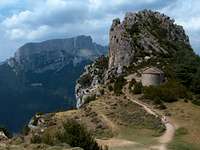 Tella & Castillo Mayor
The North slopes of the Escuaín gorges are formed with several gorgeous limestone cirques, the most famous of them being Circo de Gurrundué, a common hiking destination accessible for all.
Several peaks that belong to the Sierra de las Tucas are common hiking goals for more demanding hikers, for example the Comodoto, the Pala de Montinier, the Punta Verde, the Tres Marias or La Suca.
These places are accessible if we follow the road on the north slope, going through Lamiana, an picturesque abandonned village, however with few new renewed cottages.
Another road follows the South slope, just under the cliffs of the Castillo de Mayor. The village of Escuaín, from which the gorges are named after, also very picturesque, is a must-see. A panoramic trail goes along the cliffs on which it lies, and overlook the gorges. The one who wants to climb the Castillo Mayor must park earlier, taking the junction to Bestué, and parking somewhere half-way to this village.
 Lamiana's Church
Escuaín is also the common starting point for people who practice canyoning.
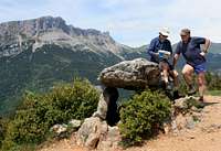 Tella's dolmen
Another fine place to discover the gorges, but not accessible from the valley itself, is the village of Tella. This village is bigger and less attractive, but nearby is a rocky promontory on which are located four ermitages that one can visit making a little circuit. The north side of the circuit proposes stunning views to the gorges of Escuaín. In tella, on thing not to miss is a prehistoric dolmen, near the entrance of the village, proof that this place was populated for a very long time.
Getting There
 Map
Map From Castillo Mayor
From France, take the Aure valley (Saint Lary), and pass the tunnel to spain (Bielsa). Drive down until Lafortunada, before the city of Ainsa.
From Spain, drive to Ainsa, and few km later turn to Lafortunada.
In Lafortunada, turn right in the direction of Lamiana or Escuaín.
View Larger Map
 Monte Perdido, Tres Marias, Gargantas de Escuain from the Castillo Mayo
Red Tape
Escuaín belongs to the Ordesa National park, so you cannot pick up flowers, disturb animals, make fires, leave rubbish, etc.Going offtrails is not forbidden but at your own risk. Beware, the stone is very loose, and scrambling down the gorges in random places is not very recommended.
Camping
The rules concerning camping/bivouacquing are a but unclear. Officially, it is forbidden, but tolerated in few places (see here).There are some accomodations in the village of Escuaín, but one needs to get there to sort it out. In Lamiana, we must absolutely mention the "Casa Rural", definitely THE place to stay to visit the Escuaín gorges, with a modic price, stunning views, and an excellent lamb chops served in the evening.