
|
|
Mountain/Rock |
|---|---|
|
|
48.42906°N / 121.82656°W |
|
|
Skagit |
|
|
Hiking |
|
|
4974 ft / 1516 m |
|
|
Overview
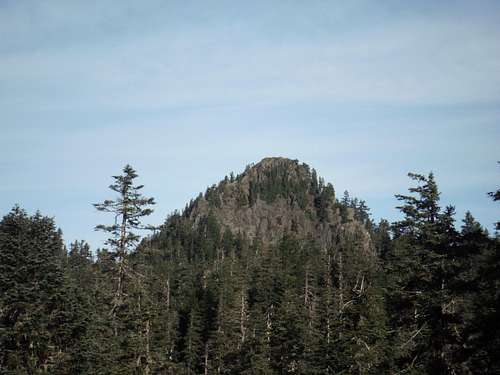
Gee Point from the trail
Gee Point is a peak that I had avoided for a long time. At 3 miles and 700 feet of elevation gain on what I thought was an easy trail, I really did not have much interest for it. It only has 214 feet of prominence which doesn't even make it a true summit by Washington standards. The higher summit on the ridge by 25 feet is Gee Point North, which is off to the north. A traverse from Gee Point requires at least a 200 foot Class 4 scramble to the true summit. I personally was saving this summit for my wife BearQueen but our schedule never really came together to knock off this summit. On the day that I was going, I was supposed to bring my friend who had recently been severely injured in an accident. I thought it was going to be so light that he would be good for this mountain. He eventually denied the invitation, which turned out to be a good thing considering his injuries.
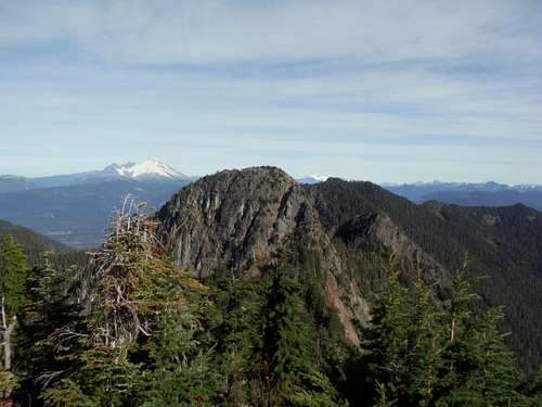 View from Gee Point looking at Gee Point North | 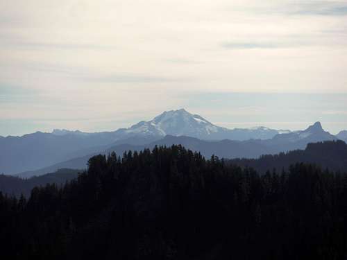 Glacier Peak from Gee Point |
From the looks of this trail many other people think the same thing about Gee Point. Honestly in some way the lack of popularity over Gee Point is both a blessing and a shame. The trail seems to be rapidly disappearing in spots and it can be hard to follow. Though this peak is easy in terms of time, part of the route up Gee Point contains some small scramble section and the last move at the time requires some care. Calling it Class 2 maybe a bit overkill but the trail is not as easy as you might think. The disappearing trail now has a lot of logs down on it and the first bit of trail is highly brushy. Without more popularity this trail potentially is at risk for disappearance.
 White Horse and Three Fingers | 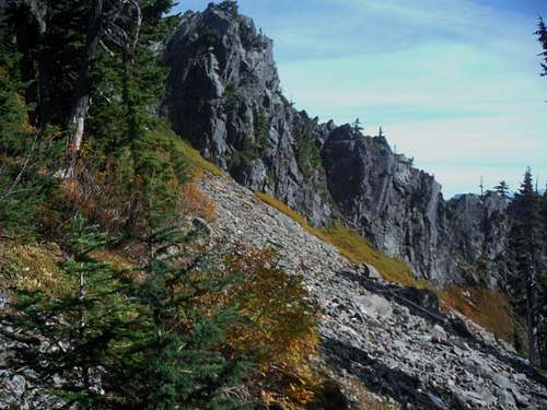 Fall Colors along the eastern slows |
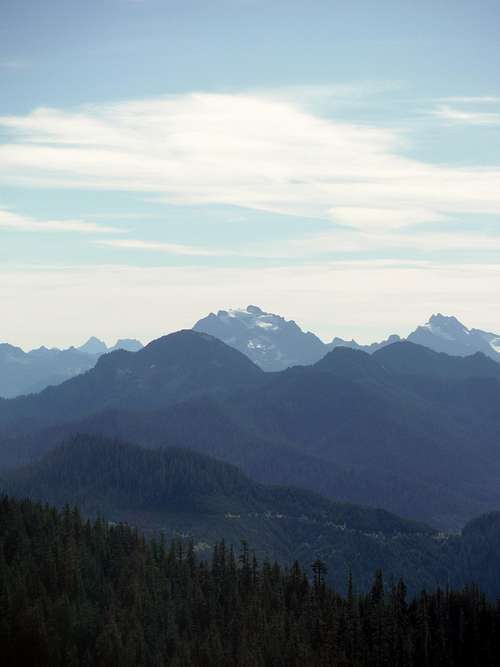
The view from Gee Point though is excellent. It would be well worth triple the effort to get this stunning view. On a clear day, Glacier Peak, Mount Rainier and Mount Baker clearly come into view with Mount Shuksan peaking out over Gee Point North. Whitehorse and Three Fingers also tower in the skyline from Gee Point. The views of the distant Olympics along with many other mountains in the North Cascades also makes this peak very special. It is easy to see why this peak was once home to a lookout though there is very little left to show where the lookout once was.
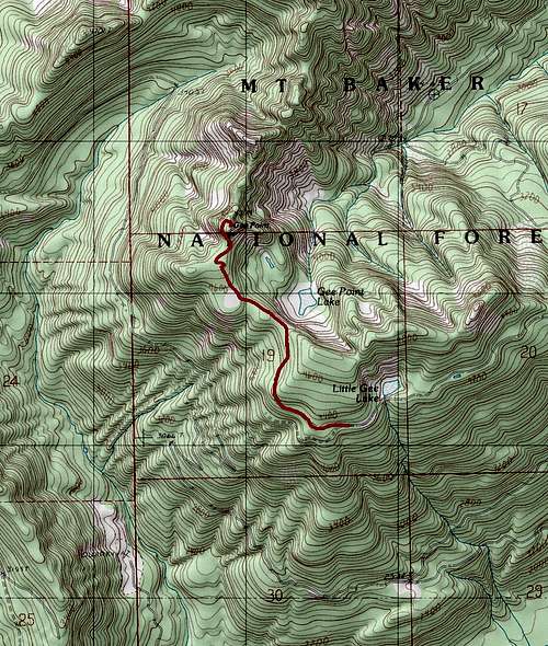
![Gee Point Map]()
The Map of the Route up Gee Point
The route up Gee Point is only 3 miles and 700 feet of elevation gain. The trail start as tough to spot path in places up a decommissioned road. The decommissioned road is now covered with slide alder though a mud path can be spotted through the slide alder. After about a quarter mile the path breaks out of the slide alder and then starts off steeply before moderate a hundred feet up until hit hits a ridge line. The trail then hits a ridge that connect to Gee Point and levels out where as of 2014 there are a number of large downed trees on the trail. From trail then once off the connecting ridge rises to near the foot of Gee Point's large rocky summit pinnacle. The trail here goes through the left of the rock a little ways from the rock. It can be hard to spot so really have your eyes open. From trail then move to the left with light scramble then heads back up steeply as it circles around to the north side. The trail which is a faint boot-path by now has one finally summit move that will require a little caution before reaching the true summit. Again it may be overkill to call it Class 2, but Gee Point is not a simple walking trail that I first thought of it to be.
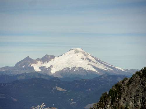 Mount Baker from Gee Point | 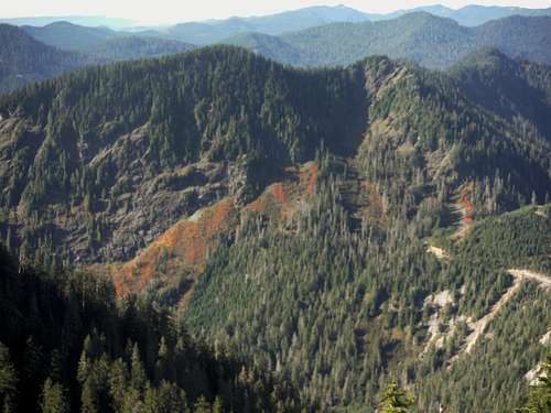 Looking down from the summit at the fall colors |
Getting There
Head east from Burlington on Highway 20 towards towards the town of Concrete Once in the town of Concrete make a right on the Concrete-Sauk Road. Cross the steel bridge (scenic in fall) and head left at the Y-intersection. Stay on the road for another 8.8 miles. Make a right onto Finney Creek Road (FR 17 on a map though not listed on the road sign). Go exactly 10.5 mile on the road where it goes from an all paved road to a mixture of gravel and paved road. Outside of a couple potholes this is easy travel. Make a right on FR 1720. Stay on this road for about 2.1 miles. Make a right onto FR 1722 (which will look like a switchback than a turn and head up hill. Stay on the road 5.4 miles to end which will have no formal parking but have a good amount of space at the turnaround to park. It should be noted that 1722 can be done with passenger cars, HOWEVER due to deep ruts in the road some caution must be used to prevent the car from bottoming out.
Route
The Map of the Route up Gee Point
The route up Gee Point is only 3 miles and 700 feet of elevation gain. The trail start as tough to spot path in places up a decommissioned road. The decommissioned road is now covered with slide alder though a mud path can be spotted through the slide alder. After about a quarter mile the path breaks out of the slide alder and then starts off steeply before moderate a hundred feet up until hit hits a ridge line. The trail then hits a ridge that connect to Gee Point and levels out where as of 2014 there are a number of large downed trees on the trail. From trail then once off the connecting ridge rises to near the foot of Gee Point's large rocky summit pinnacle. The trail here goes through the left of the rock a little ways from the rock. It can be hard to spot so really have your eyes open. From trail then move to the left with light scramble then heads back up steeply as it circles around to the north side. The trail which is a faint boot-path by now has one finally summit move that will require a little caution before reaching the true summit. Again it may be overkill to call it Class 2, but Gee Point is not a simple walking trail that I first thought of it to be.