
-
 4388 Hits
-
 73.06% Score
-
 3 Votes
|
|
Route |
|---|---|
|
|
42.85050°N / 0.312°W |
|
|
Download GPX » View Route on Map |
|
|
Mountaineering |
|
|
Spring, Summer |
|
|
One to two days |
|
|
PD (poco dificil, low difficulty) |
|
|
5.0 (YDS) |
|
|
II |
|
|
Overview

The Arete de Geodesiens (name is due to the official geodesics Peytier and Hossard that climbed by first time the mountain) is the ridge N-NE of the peak Pallas. The exposed and the grade II+ make of this route an itinerary only for mountaineers with a little of experience.
The trailhead is the refuge of Arremoulit and generally the climb is maked in two days (5h 30min or 6 hours to summit and 5h for descent is very long for one day). It's a good idea the night in the refuge and the climb in 2 days.
Note about GPX file: it was an ascent across Geodesics descending Ledormeur
Getting There
Caillou de Soques (1392m)The approach is possible from Pau (France) and Port of Portalet (Spain).
-From Portalet (1794m) we'll descent the road D-934 for a few of km to reach the little parking under the ridge of Arrious-Soques.
-From Pau follow the road in diretion south to Arudy, Laruns, Eaux-Chaudes and Fabreges. After the dam of Fabreges we'll reach the parking. Near of this area is the station of turistic train of lake of Artouste.
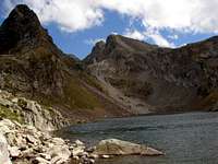 Lake d'Arrious
 Paso d'Orteig
Day 1: Approach to refuge d'Arremoulit:
Time: 3h 30min.
Slope: 900m.
We'll walk in east direction following the HRP (Haute Route of Pyrenees) in the ravine of Arrious with a good path. We'll pass the Cabane d'Arrious and we'll reach the Col d'Arrious (2259m, 2h30min). In the col we'll follow the signal to right side and we'll leave the nice lake of Arrious in left side (south) to cross the nice and spectacular Pass d'Orteig in the north wall of the peak of lake d'Arrious (2495m). The pass is a little stepcrossing of 1 or 2 meters wide equiped with a metallic rope in right side (grade I+) very easy. With snow and ice I think is a dangerous walk. The view of Lake of Artouste in north side is nice. Even in winter is advisable the descent with precaution to lake and don't walk the pass (30 minutes more). At the exit of the pass (2370 meters) the view of Pallas and Balaitous is wondefull over the lake of Arremoulit. We'll must to descent now to the refuge d'Arremoulit (2280m, 3h30min).
 |
 |
 |
 |
 |
Route Description
 Pallas from Arremoulit
Day 2: Geodesics Ridge
Time: 3h
Slope: 700m.
We'll begin to walk in east direction to the visible Col of Pallas (right) but before the col we'll leave the route to border the west face in north direction in a point near of a little lake signaled with cairn in both directions (left to Pallas and right to Col of Pallas). After a long walk among a lot of stones we'll walk under the ridge W of Pallas to reach a point to turn to the Breche de Geodesiens (2786m) in right side (east) to enter in the desired ridge NE between the peak Artouste and Pallas. It's possible the entry just in the Breche or in a rocky spun just in the point what the route turn to the Breche (signaled with cairns).
The itinerary go in the edge of the ridge with some walks in the right side to evitate some aiguilles, specially a big Gendarme, to reach a new gap, a couloir in left side (great attention to the cairns, PD-) and finally the great blocks of stone (PD, exposed, good rock) to the summit. In this last part it's usefull the use of the rope for the friends with fear.
The descent is better to do it for the normal route of the Chimney Ledourmeur and in the area of Lakes of Arriel we'll climb to the Col d'Arremoulit (south-west) to descent to the refuge across the Col of Pallas.
 Spun Spun |
 Entry to ridge Entry to ridge |
 Ridge Ridge |
|---|
Essential Gear
 Geodesics Ridge
Rope of 30 meters, harness and helmet. The descent of chimney Ledourmeur had an anchorage in the second part of 30-35 meters (the most vertical) and you must to use some strips or carabiners to make the last part of 15 meters with the rope (really only 4-5 meters are grade II-, the rest is an easy grade I and nobody use it). For this reason generally the people make the last 5-6 meters (with less fall) without rope. If you had a rope of 60 meters is usefull to descent the full chimney in a rappel but I think it's not necessary.
In winter or early in the season: crampons and ice-axe.