
|
|
Route |
|---|---|
|
|
44.02440°N / 71.8314°W |
|
|
Hike |
|
|
Half a day |
|
|
Class 1-2 (YDS) |
|
|
Approach
Use the Moosilauke Ravine Lodge Approach described in the Getting There Section.
Route Description
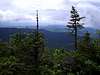
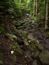
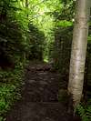
This route consists entirely of the 3.7 mile class 2 George Brook Trail ascends the SE Slope and starts at the Moosilauke Ravine Lodge trailhead (2460'). From the end of Ravine Road follow a logging road for 100 yards before heading west and descending to cross the Baker River over a bridge. You will then climbing northwest up along the George Brook crossing the brook on another bridge 0.6 miles from the trailhead just before the Snapper Trail junction (2620'). Continue northwest on the George Brook Trail reaching a sign for the McKenney Forest (3350') in another 1 mile. Here the trail will leave the brook heading traversing the mountain east for 0.5 miles before heading north along an old logging road. After leaving the logging road the trail will continue 1.6 miles to the summit heading northwest up onto exposed southeast slope.
 |  |  |  |  |
Essential Gear
None during the snow-free season, however gear such as ice axe, crampons, snowshoes, and skis may be used, or even mandatory, during winter conditions. A windbraker is always a good idea above treeline.
 |  |  |  |  |
Miscellaneous Info
If you have information about this route that doesn't pertain to any of the other sections, please add it here.