
|
|
Mountain/Rock |
|---|---|
|
|
36.44825°N / 50.94211°E |
|
|
Mountaineering |
|
|
Summer |
|
|
14534 ft / 4430 m |
|
|
Overview
Click for Introduction to Central Alborz Mountains.Click to see the Map of the Takhte Soleyman Massif.
Important Note About Elevation: Ghobi and Kalahoo sit in a remote part of the Takhte Soleyman Massif. Maps do not depict the details of the topography of the area very accurately. The Iranian 1:50 000 Map gives an elevation of 4412 m for Kalahoo and 4399 m for Ghobi. The Soviet 1:50 000 Map gives an elevation of 4416 m for Kalahoo and 4419 m for Ghobi. I believe that my own GPS measurements are probably more accurate than anything that appears on any map. My GPS showed an elevation of 4431 m for Kalahoo and 4433 m for Ghobi. Kalahoo is probably minimally taller than Ghobi (although from some angles Ghobi seems taller). Therefore, I have decided to use a value of 4431 m for Kalahoo and 4430 m for Ghobi.
Note About Names: Mountain climbers use the names Ghobi (or Ghabi) and Kalahoo. Locals on the north side of the mountains refer to these peaks as the “Piteh Ghar” Mountains.
 North Slopes
 North Side
 South Side
Only 34 Km (21 miles) away from the Caspian Sea, 4455 (14616 ft) m above it (Caspian Sea, which is not a “sea” but the largest lake in the world, is 25 m below sea level)..
Ghobi and its neighbor to the east, the 4431 m Kalahoo Peak are the northern-most high peaks (above 4400 m) of the Takhte Soleyman Massif. To the north Ghobi and Kalahoo create rugged and very steep slopes that drop 2500 vertical meters to the bottom of the Eza Rood River Valley. Only 30 Km further north, this river drains into the Caspian Sea.
Caspian rain forests cover the valleys to the north, east and west of Ghobi up to an elevation of 2300m. These valleys are often filled with clouds generated by the Caspian Sea moisture.
 Double Decker Clouds Double Decker Clouds | 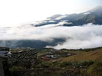 From Kia Neshinan From Kia Neshinan |  From Kia Neshinan From Kia Neshinan |  North Face North Face |
The summit of Ghobi is actually made of two high points. The one on the west is slightly higher.
To the south, Ghobi and Kalahoo connect to the main spine of the Takhte Soleyman Massif via the 4104 m Kaljaran Pass. The shortest way for reaching the summit of Ghobi is from the south via the Kaljaran Pass. The town of Roodbarak (elevation 1400 m) serves as the usual starting point. From Roodbarak, you will drive to a place called Vandar Bon (2350 m) and then hike up to the Kaljaran Pass where you can overnight camp. The next day you can climb Ghobi and Kalahoo and descend back to Roodbarak. This route will not take you through any forest and will not allow you to see the impressive north faces of Ghobi and Kalahoo.
 Saved from the Mud
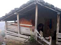
To see the beautiful sites on the north side, you will have to hike into very remote areas. From the summit of Ghobi, you can head northwest to reach the top of the 4340 m Looy Na Peak and then follow a long and slowly descending ridgeline north. This ridgeline gives rise to 6 major peaks that can be climbed as an added bonus (see footnote below for the names of these peaks). After a 20 Km hike from the summit of Ghobi you will reach the seasonal village of Kia Neshinan (2400 m) which sits just above the edge of the forest. This village is inhabited only in summer (when we reached the village on June 22, there were only 3 young men in it).
 The Caspian Forests on the north side of Ghobi
To reach a road to take you to the Caspian coast, from Kia Neshinan, you will have to hike down through the forest to another village named Gaznachal (1900 m). After Kia Neshinan, we became hopelessly lost in the dense fog and the crisscrossing network of trails/semi-trails and in the end had to ask a young man from Kia Neshinan to guide us one hour (4 Km) through the forest to take us to a nearby logging road (2000 m) where we were lucky to catch a ride (2.5 hrs through the dense forest) to reach the coastal town of Tonkabon.
 Dark Forest Dark Forest |  Conjoined Trees Conjoined Trees |  Our Ride Our Ride | 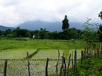 End of Descent End of Descent |
Views from the summit of Ghobi
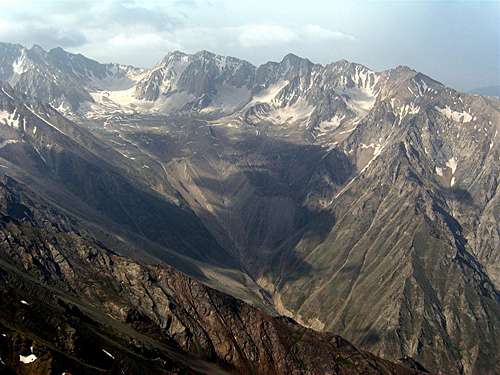 View of Haft Khan Peaks and Glacier from Ghobi
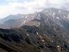 Alam Alam |  Kalahoo Kalahoo |  Korma Korma |  Eza Rood Eza Rood |
 Sehezar Sehezar |  Looy Na Looy Na |  Mazi Gardan Mazi Gardan |  Shah Rashid Shah Rashid |
Route Information:
Click below to see the route pages for the Kalahoo Peak:
Routes for Kalahoo
From the top of Kalahoo, turn west and follow the ridge-top 30 minutes west roughly 70 vertical meters down to a saddle. You can bypass the east summit of Ghobi on the south side of it and then go up to reach the west summit.
 A Herd of Rams
Footnote:
Names and links for the peaks on the mentioned ridgeline (south to north): 1) Looy Na 4340 m, 2) Mazi Gardan 4140 m, 3) Shoor Gardan 3953 m, 4) Reka Poshteh 3640 m, 5) Dakooh 3590 m and 6) Peak 3483 m.