
-
 7854 Hits
-
 86.85% Score
-
 23 Votes
|
|
Mountain/Rock |
|---|---|
|
|
36.48814°N / 114.52523°W |
|
|
Scrambling |
|
|
Spring, Fall, Winter |
|
|
2172 ft / 662 m |
|
|
Overview and Routes

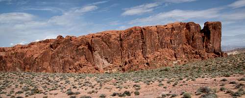
How much Gibraltar Rock resembles the famous Rock of Gibraltar is up to the beholder; while I can see some resemblance, what I really see is a massive red ship afloat on a sandy sea.
The USGS quad that shows Gibraltar Rock does not mark it by name (and for some strange reason gives elevation in meters), but if you google something like "Gibraltar Rock Valley of Fire," you will get several photos and several pages that mention it. However, until posting this page, I never saw anything remotely resembling climbing information except for here, a blog maintained, not too surprisingly, by an SP member.
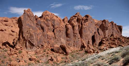
Gibraltar Rock is a prominent formation comprised of red sandstone near the end of the road to White Domes. As one drives north on the road, Gibraltar Rock is off to the right just before the the road loops back south to end at the parking area at the base of the White Domes. Just off the road (it literally takes just a few minutes to hike to the base of the formation), the peak is a major attraction for photographers (because it is east of the road, it looks spectacular in the late afternoon and at sunset), but there is no evidence that its heights are frequently attained by humans. This might be because from the road, the peak looks technical-only; there is, however, a route to the highpoint that entails a lot of Class 3 and a couple of Class 4 sections (this route seemed very similar to CP's and probably was the same one), and there is at least one Class 5 route that, while dangerously loose in sections, is easy enough for skilled scramblers to take on unroped. I climbed both, and both will receive more elaboration in the routes section of this page.
The summit of Gibraltar Rock has panoramic views of the surrounding area, and even during the non-prime photography hours, the colors on display will still astound most people.
Roadside viewers will notice a deep cleft separating what looks like the main mass of the peak from a possibly higher summit. Closer inspection suggests that the technical-looking summit is lower, and that is correct. However, there might be a non-technical (or at least lower Class 5) way to that summit (again, more details in the routes section), and although it is not the highpoint of the formation, it might be a more desirable prize.
 |  |
Routes
We'll cover two here; I suspect there are at least two more "scrambleable" ones, but I did not check them out.
"Standard Route"
This peak doesn't appear to be climbed often enough to really have a standard route, but this route seems to be the easiest one. As written earlier, it seems to be the one CP found, for it goes up a canyon, climbs a wall, goes up another canyon, and then climbs another wall to reach the summit "plateau."
So, what I did:
First, I ought to mention that this is not a long route. My GPS device registered barely over half a mile, and it took me about 20 minutes to find my way to the summit on my first try, not counting an intentional diversion up to a neighboring ridge that seemed to offer an interesting climb (and did). The starting point is at about 2000', and there is an initial drop of approximately 150', so total elevation gain to the summit is actually around 350'. It doesn't sound like much, and it's not, but it's a fun route.
Since no apparent weakness existed on the western side, I aimed for the south end and there found a canyon splitting the two main ridge systems of the formation.
 The canyon The canyon |  |
After climbing the wall, I found myself in a smaller, narrower canyon, and I went up it a little until spotting a Class 3/4 way up the right side and onto the summit plateau.
A narrow, shallow mini-slot blocked my way to the highpoint here, so I just jumped across and then followed easier terrain a short way to the summit, where I did not find either a cairn or a register.
 The route... The route... |  |  |  |
Alternate Route-- Technical Scramble
This route makes an already-short route a little shorter, but it is more challenging, and the rock at the start of the route is awful. Difficulties are mostly Class 3 and 4 with some Class 5 spots, none exceeding 5.4, lower on the route. Unfortunately, the Class 5 spots are also where the rock is the worst. Nevertheless, it is a fun little route. One might want to use it for the ascent and use the standard route for the descent. Keep in mind that the standard route will be harder to find and follow from the top unless you have climbed it before, but a good route-finding nose should take care of you.
As you enter the canyon to begin the standard route, look to your right and notice a steep, loose-looking gully. You will climb this gully to its end; the crux is getting around the large chockstone visible in the first picture below. Remember-- the climbing itself is not that difficult even though it is Class 5, but the really loose, easily breakable rock makes things more difficult and dangerous. Above the chockstone, the climbing gets a little easier but still stays in the Class 4-low 5 range.
 Start and crux Start and crux |  Above the crux Above the crux |
 To exit to the summit area, use this... To exit to the summit area, use this... |  ...or this. ...or this. |
Getting There
In Valley of Fire State Park, turn north onto the road signed for White Domes and the Visitor Center. The road is supposed to 5.5 miles, and I have never clocked it, but it seems about right. Less than a mile from the end of the road, there is a 180-degree bend back south. Shortly before the bend, there is a parking lot on the left (west) side of the road. Park in the lot and then cross the road to begin the short approach to Gibraltar Rock.  Locator map Locator map |  Near the parking area... Near the parking area... |
Red Tape
The daily entrance fee is $10 per vehicle.Technical rock climbing-- using gear-- is permitted only in certain sections of the park. Climbers are asked to inquire at the visitor center or contact park staff. I do not know if Gibraltar Rock is open to technical rock climbing but suspect that it is not; the sense is that there is an emphasis on restriction, not access. In particular, the concern seems to involve fixed gear for rappelling, so that might mean that trad climbing is okay, but you shouldn't go in expecting that to be understood. Do yourself a favor and check first.