
-
 20353 Hits
-
 70.12% Score
-
 1 Votes
|
|
Trailhead |
|---|---|
|
|
38.13800°N / 105.6008°W |
|
|
Custer County |
|
|
9000 ft / 2743 m |
Getting There
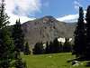
From the center of Westcliffe, Colorado head south on Colorado Highway 69 for a short distance. Just as you are leaving town take a right turn on the well signed Hermit Road.Continue west on Hermit Road for almost six miles. About halfway through the six miles the road will come to an intersection where the pavement heading west ends. Continue west (straight) on the now gravel Hermit Road. Spread Eagle Peak is now towering ahead of you.
At about six miles from Colorado Highway 69 you will come to a fork in the road. The left fork heads up the four wheel drive road to Hermit Lake and ultimately to Hermit Pass. Take the right fork which is the cut-off to C.R. 172 North Taylor Road. Take a left on North Taylor Road towards some private residences. You will soon see a sign for the Gibson Creek Trailhead and pass through the forest service gate.
Once through the forest service gate you will see parking for horse trailers and group camping. This last 0.2 miles from the gate to the signed trailhead is pretty rough but is passable to most high clearance vehicles. Four wheel drive would most likely be necessary in wet or snow conditions.
Destinations Accessible from the Gibson Creek Trailhead

Lower Lake of the Clouds

Middle Lake of the Clouds
Upper Lake of the Clouds
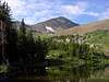
Spread Eagle Peak - 13,423'
Mount Marcy - 13,490'
Point 13,513'

Point 13,524'
Rainbow Trail