Vague Long Term Planning
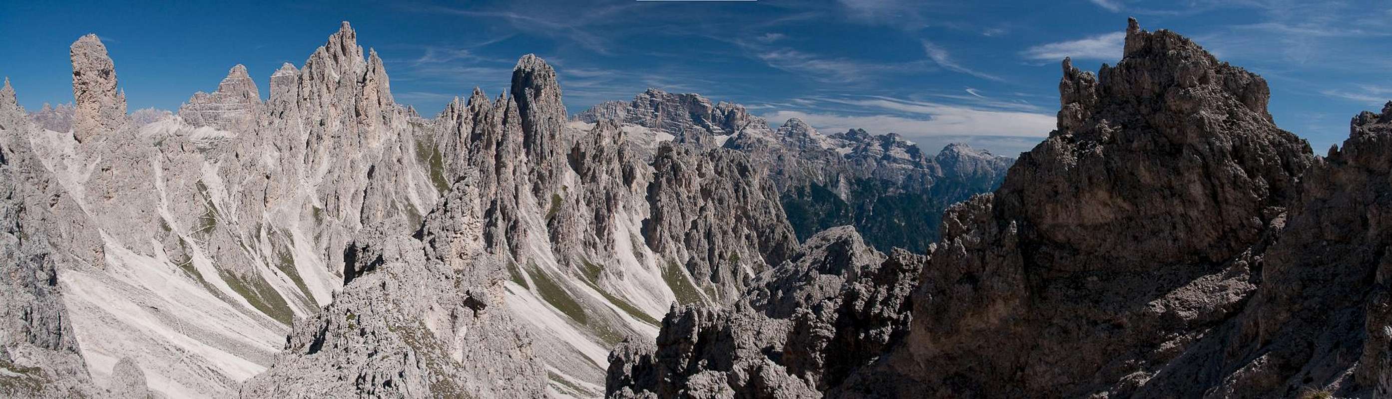
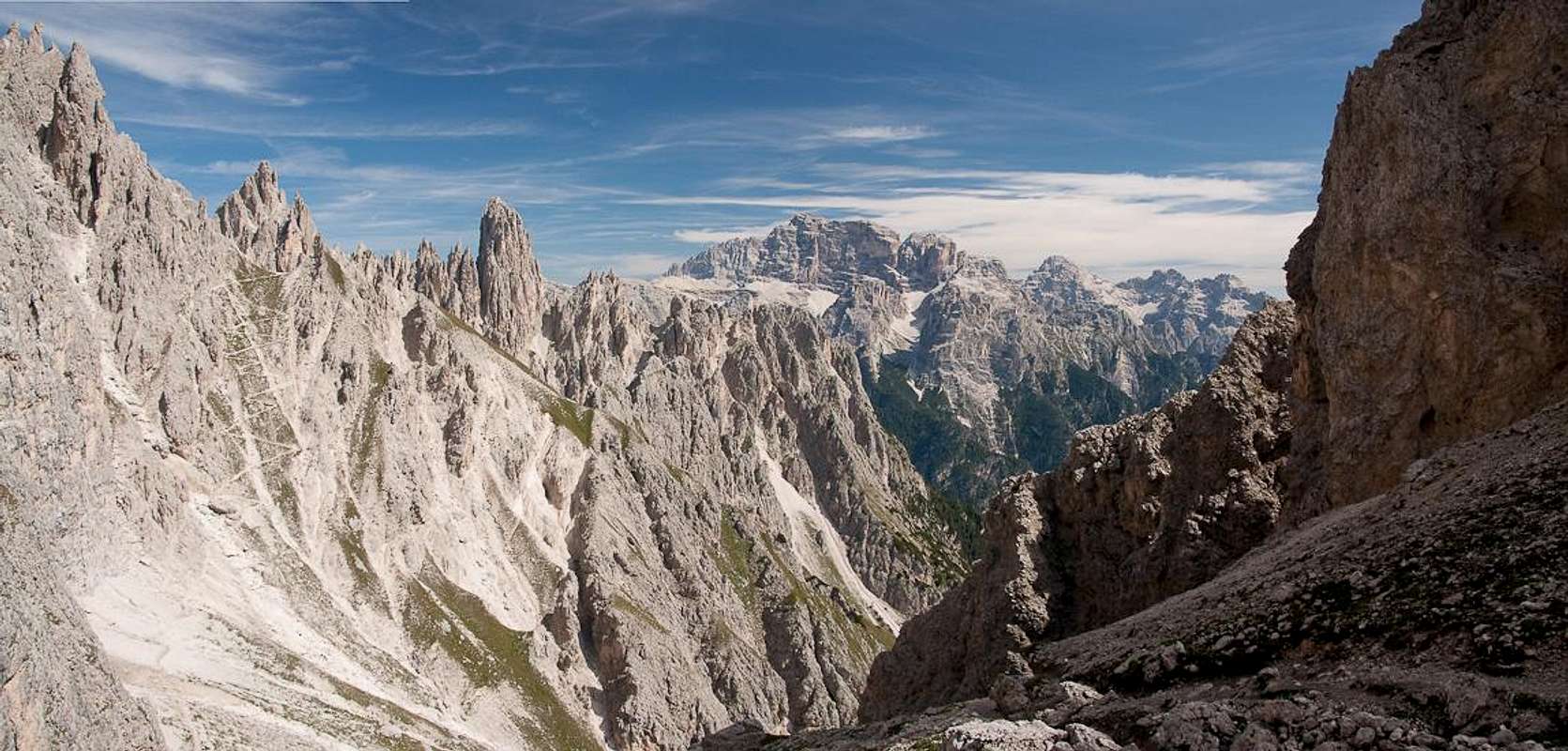
![Cadini di Misurina]() The fascinating scenery of the Cadini di Misurina The fascinating scenery of the Cadini di Misurina |
10 years ago I first set my eyes upon the fantastic Dolomite mountain group of the
Cadini di Misurina while I was doing the overcrowded hiking loop, which circles the famous
Drei Zinnen / Tre Cime di Lavaredo. I was immediately attracted to this dense assortment of pinnacles and towers and in my mind a vague determination formed to inspect it up close some time. Five years later the same thing happened when – during a bad weather period – we visited the
Sexten Dolomites / Dolomiti di Sesto for a day trip around the rather unimportant
Morgenkofel. From one of the saddles suddenly the view stretched towards the
Cadini and my vague determination received a boost.
Again five years went by and when I started to prepare for the recent vacation, which took us to
Sexten / Sesto itself, I consulted my guidebooks with the
Cadini somewhere in the back of my mind. I found several suggestions, which in the end boiled down to two day-trips: the
Via Ferrata Bonacossa which runs right through the group and
Sentiero Durissini, which circles it in the east. Both trips can be done as loops starting from the southern end of
Misurina Lake.
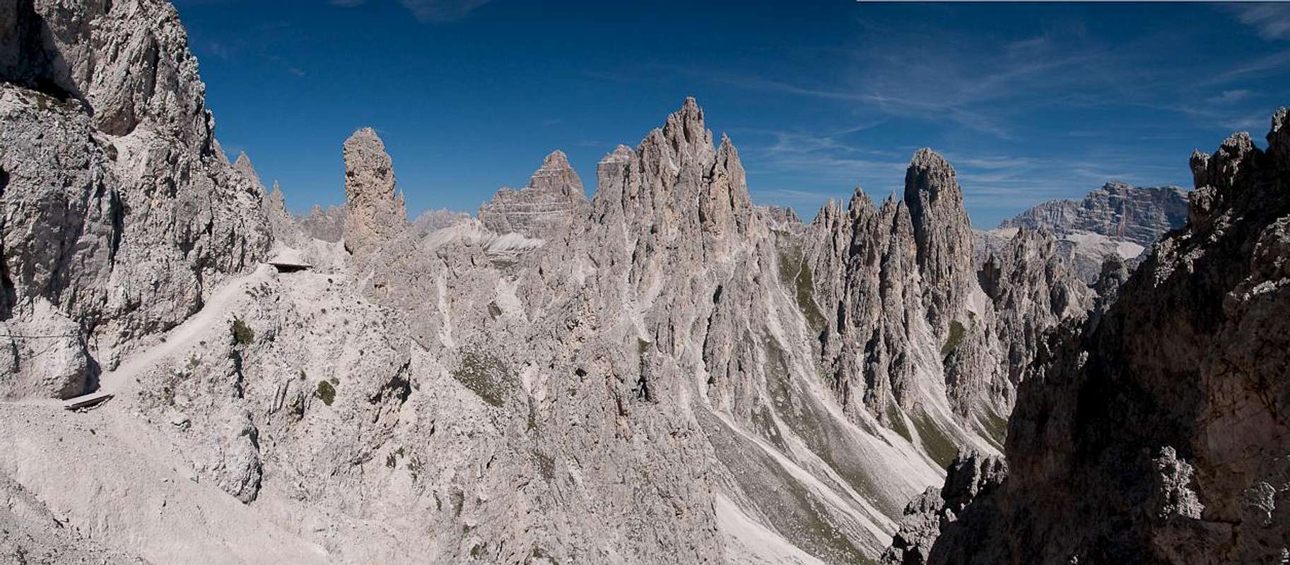
The Cadini - a maze of towers |
For warm-up, day one of our vacation took us to the
Carnic Alps Main Ridge (easy, panoramic walking terrain) but a forecast for wonderful weather for day two decided me to prove Gabriele wrong, who writes on his SP page about the weather in the Cadini:
“I've spent here, in different years, 3 climbing days and 3 hiking days (with my family) and, maybe I've been unlucky but ... they were all raining days :( “. To my surprise, Judith immediately agreed not only to one of the trips but both, suggesting the apparently more difficult
Sentiero Bonacossa for a later date. With sunshine on my mind and red wine in my stomach I happily sank down sleep that night …
Misurina
The Dolomites are crowded anyway but there are spots which are even more crowded than others. I already mentioned
Drei Zinnen / Tre Cime as a deterring example above but
Misurina Lake to the south-west of the formation is not much better. There are a handful of hotels, a few souvenir shops and ample parking space which can accommodate even the biggest crowds. And they come by the busload! The lake is famous for its views towards
Sorapis in the south and
Drei Zinnen / Tre Cime in the north but few of the visitors realize that one of the most bizarre mountain groups on earth is located to its east: the
Cadini di Misurina.
When we arrived at the lake – after a 40 minute dash from
Sexten / Sesto (don't expect me to drive slow, once I head for an interesting destination in beautiful weather) – it was 8:30 a.m. And the shores of the lake were still empty. The first souvenir shops were only opening their shutters as we searched around for a reasonable parking space for the car. We found one at the chair lift to
Rifugio Col de Varda and ignored the signs that only customers of the lift were allowed to use it. After all, if the lift had already been in operation we might even have been their customers. But we were one hour to early and thus set out on foot.
Though
Misurina Lake is located already above 1700m, we immediately plunged into a dense forest of firs larches and pines. Being aware that all around the likes of
Cristallo,
Dürrenstein / Picco di Vallandro and
Sorapis could be seen I grew even more restless and impatient with our slow progress. Above the timber line was where I wanted to be. But it would turn out to take quite a while until I got there.
First we had to cross the ski run several times, which comes down from the Rifugio. We stayed on the support dirt road, which only slowly creeps up the slopes, making wide turns to avoid the steepest parts. Finally we came to an intersection dividing between
Rifugio Col de Varda (which we ignored and saved up for later) and
Rifugio Citta di Carpi, the destination of our first stage. Here for the first time some of the expected views presented themselves but our route started to descend again and my mood started to lean to the dark side. And down we went – down, down, down.
![Cima Cadin de Misurina, Cima Cadin della Neve, Cime Cadin di Maraia]() Cima Cadin de Maraia
Cima Cadin de Maraia
Finally the path swept east – we had passed the southernmost bastions of the
Cadini and now headed towards a giant scree slope. And now I understood the reason for all this downward mobility: we had to pass underneath this huge pile of debris. Arriving there we found that the rocks had cleared quite o big area of all vegetation so that finally we could set our eyes on the Dolomite Groups in the south:
Sorapis in the west,
Marmarole in the east and with a bit of luck we found a place with a view to the west as well:
Cristallo,
Le Tofane, even
Queen Marmolada could be seen. But then: trees again …
![Sorapis]() Sorapis Sorapis | ![Le Tofane]() Le Tofane Le Tofane | ![Marmolada]() Marmolada Marmolada |
Finally we left the dirt road we had been walking from the start and chose a narrow path which turned north-east. The southern tip of the
Cadini had been passed. Still we hadn't seen much of the group itself and I started to wonder if this would turn out to be one of these loops where the object you loop is to close to be seen. We would see soon as it became evident that the timberline was near. And
Rifugio Citta di Carpi was close as well – we couldn't see it but an Italian flag marked its location. We sped up and finally reached the end of stage one.
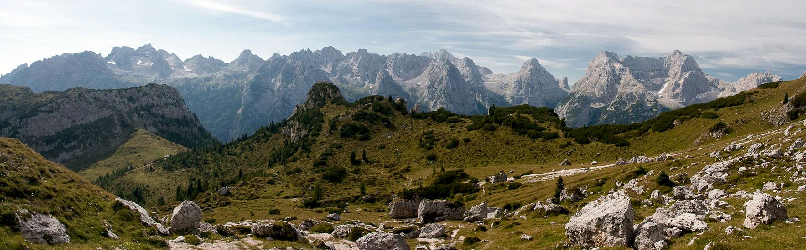
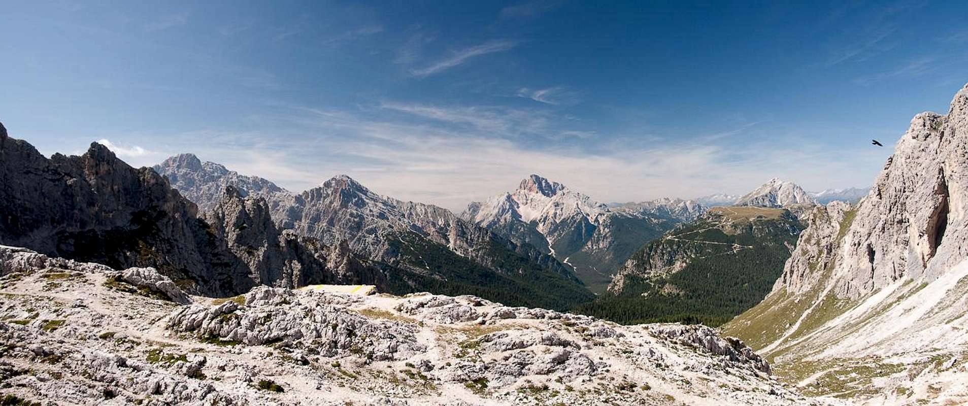
Sentiero Durissini
Marmarole and Sorapis as seen from the vicinity of Rifugio Citta di Carpi |
is quite a revelation: having seen nothing (or not much) for most of the way we swept around a corner and suddenly were blasted with a skiline of towers. My expectation was proven wrong. Here at least the
Cadini were on full display. Basically you can see the whole eastern skyline of the group. Moreover the
Marmarole and
Sorapis are still visible in the south and in the east the southern part of the
Sexten Dolomites / Dolomiti di Sesto comes into view. You simply have to sit down and take in the vista.
Cadini seen from Rifugio Citta di Carpi |
At the Rifugio two climbing parties were preparing for the towers on both sides of
Forcella della Neve. We grunted a short greeting and moved on. A panoramic path leads to the base of one of the lower formations and there wriggles its way up the scree covered rocks. At that time we didn't know but this was a sure sign of things to come: loose ground to cover on our way up to a saddle – down on the other side again with questionable solidity of the footing. We reached an (unnamed) saddle and had our first glimpse of
Cadin della Mussa with its frame of pillars, especially
Cima Eötvös and and
Cima Cadin di San Lucano. From afar we saw
Forcella della Neve and the path which winds up there, another party was just about to reach the saddle and we mistook it for our next destination.
However, halfway up the Cadin, signposts at a trail intersection informed us, that our chosen route would lead us back across one of the big scree field to the eastern outside slopes of the
Cadini. We had to pass underneath
Cima Cadin di San Lucano, first heading for
Campanile di Maraia, a small steeple in the north-east of the group. At its base the path turned sharply upward and here was our first forcella,
Forcella Cristina, with
Cima Cadin Deserto towering high above it. What we didn't know – we were just about to enter a bizarre dreamscape.
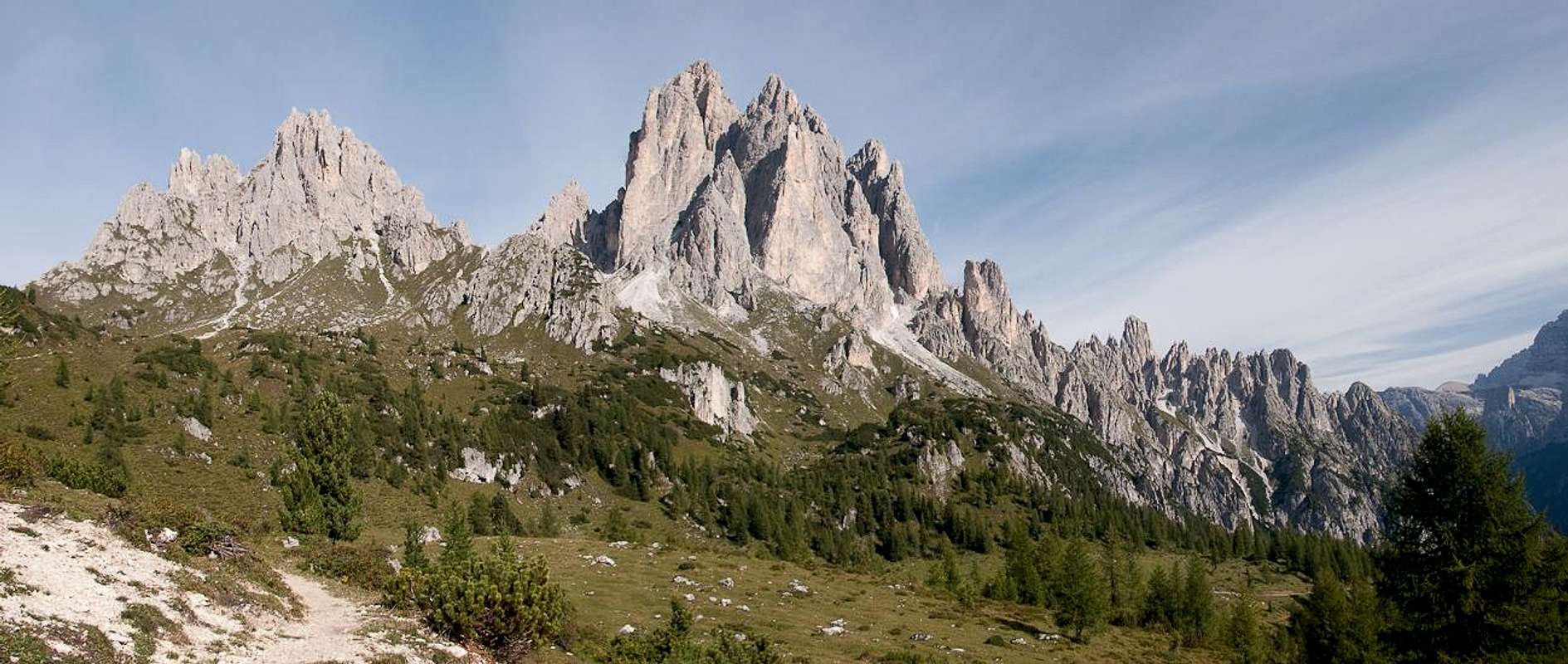
A Dreamscape
![Looking from Forcella Cristina to Forcella Cadin Deserto]() Between Forcella Cristina and Forcella Cadin Deserto
Between Forcella Cristina and Forcella Cadin Deserto
But before we did we once more admired the views towards the
Marmarole and
Sorapis Groups which were just about to vanish from our sight as we scrambled up to the saddle. We passed underneath a narrow spire,
Torre Caldart - and found ourselves in improbable surroundings. Only a few steps ahead was the next saddle,
Forcella Cadin Deserto, but in between the ground sloped sharply to the right, falling away through a narrow gully into an abyss. Pictures can't tell the whole story as the third dimension is missing. A narrow path clung to the walls to the left and crossed the scree slope and we carefully placed our steps to cheat our way towards the forcella, basically praying that gravity would not notice us in this place. We were successful but suddenly our jaws dropped.
A veritable dreamscape opened in front of us: a cirque framed by two lines of pinnacles and towers. It opened to the east where
Zwölfer / Croda dei Toni in the southern
Sexten / Sesto Dolomites attracts attention. The sky had turned a deep blue and we decided to stop and have our lunchbreak at this very spot. Unpacking the food, what struck us most were
Zimon de Croda Lissa, a pyramid-shaped tower and
Torre Siorpaes, a round one, both being connected by a ridge of (seemingly) endless pinacles.
View from Forcella Cadin Deserto |
After a while our boggled minds returned to a somewhat normal state and we started looking around for the further route. On our side of the cirque half a dozen switchbacks would lead us to the base of the valley but on the far side, right underneath
Zimon de Croda Lissa we would have to climb what appeared to be a vertical face, luckily by a zig-zagging path, which would lead to
Forcella Sabbiosa, the next milestone of the route.
Lunch finished, we headed down and found the route much easier than we had expected from above. We quickly were inside the Cadin, which offered us a view towards the
Monte Brentoni Subgroup of the
southern Carnic Alps. The ascent to
Forcella Sabbiosa turned out to be real easy though the zig-zagging path kept crossing a rockfall chute, where footing was a bit tricky.
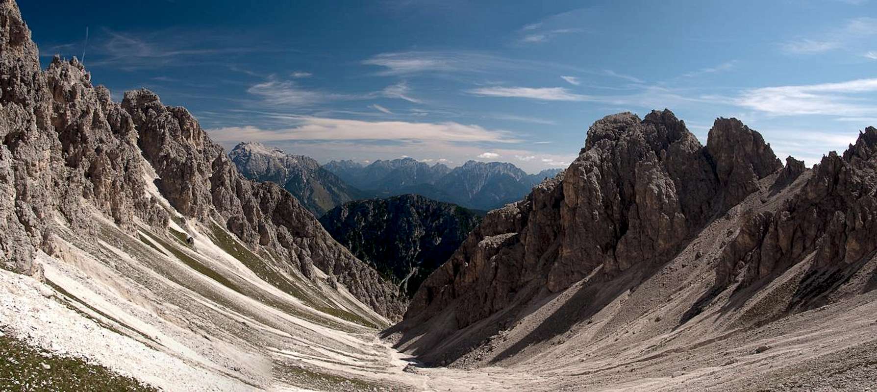
Cadin Deserto
View from Forcella Sabbiosa |
If our minds had been boggled before now they were simply blasted away with what we saw. Basically we had the same view in front of us but we had come much closer. Right underneath was
Cadin Deserto, a narrow gorge. Up front
Drei Zinnen / Tre Cime were coming into view, adding themselves to this landscape of towers. Our path led across a ledge to the far side of the forcella, but then suddenly dropped into the cadin. The quality of the path turned out to be horrible with a lot of passages where rockfall had taken away the proper trail and scree covering everything. We rather slid down during our scramble to the base of the gorge.
Which turned out to be much wider than it had looked from above. Framed by towers scree slopes gave it a cirque like aspect. We soon we were climbing again - first a traverse but finally a steep scree ascent to the next saddle,
Forcella della Torre. Looking back the hole horror of the previous descent revealed itself once more but we concentrated on the way ahead.
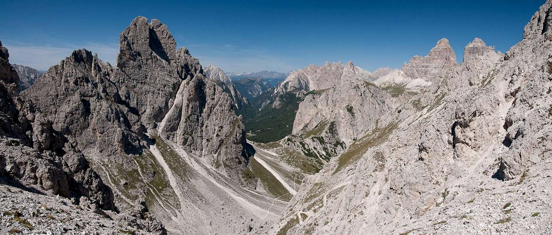
The scenery suddenly changed. Now
Cadin Deserto was history and
Cadin dei Toci and
Cadin del Rinbianco were ahead.
Torre Wundt took center stage but also
Rautspitzen / Monti del Rudo could be seen. Not to mention
Drei Zinnen / Tre Cime. The trail took us to the sole protected section of the whole route which turned out to be not easy to master for smaller people like Judith. However, we both made it and finally started going down into
Cadin del Nevaio.
Apart from two couples we had not seen any people the whole day - but this now changed. While we were descending about a dozen hikers – different parties – came the other way. All seemed to be on a trekking trip, given the amount of stuff they were carrying on their backs. The path was what we now knew to be typical Cadini quality – brittle with a lot of rockfall potential. We were getting close to
Rifugio Fonda Savio now but before we got there we had to traverse a snowfield which had survived all year until now in mid September.
View from Forcella della Torre |
It turned out to be much less difficult than anticipated – too many people had been this way already and good tracks led across. However, on the other side – on the ramp which leads up to the Rifugio – a kind of stampede appeared to be going on. From all sides people arrived resulting in a considerable traffic jam. The ramp is protected and though the protection is not strictly necessary everybody wanted a touch of the cable. We slowly wound our way to the top.
Cadin dei Toci
![Rifugio Fonda Savio]() Rifugio Fonda Savio
Rifugio Fonda Savio
We finally had made it to the last stage of our trip, the descent from
Rifugio Fonda Savio back to
Misurina. But before we set out we spent some time watching the coming and going at the shelter. It is beautifully located underneath the
Cime Cadin dei Toci, with
Torre Wundt towering above the hut. A platform offers a good view towards
Zimon di Croda Lissa and
Drei Zinnen / Tre Cime and in the back (south)
Cima Cadin de San Lucano stands as a reminder that most of the Cadini Group is still hidden from view. What struck me most, however, was the (once again) complete change of scenery: from the closed saddles and gullies in the east of the group we had moved on to the wide
Cadin dei Toci and here the well known Dolomite scenery of
Cristallo,
Hohe Gaisl / Croda Rossa and
Dürrenstein / Picco di Vallandro was hovering in the distance. In between far open spaces, something which we weren't used to after this day of closeness.
But everything has an end and so we prepared to leave. At the same time half a dozen guests of the shelter also prepared and we had to file for the narrow (again protected) descent. After the „difficult“ section we quickly left the competition behind though we kept scouting for the second of our Cadini destinations,
Sentiero Bonacossa. We found the intersection close to the refuge and decided that
Forcella di Diavolo, which was visible from where we stood, had to wait for another time. In a wide sweep the hiking trail led to the mouth of the cadin, still offering good views all around.
Before we plunged beneath the timberline we had another break and then lost everything from sight. A long, winding path took us down to a clearing (last view of the Cadini) and then turned south, keeping the elevation as it brought us to
Lago di Misurina. We ended up somewhere on the ski run where we had started with the chair lift overhead, then took the maintenance road to its base and finally returned to the car. From where it stood we had a perfect view of
Drei Zinnen / Tre Cime mirrored in the lake, giving me the opportunity to finish this TR with a picture postcard view ;-)
![The Mirror Lake]() The Mirror Lake
The Mirror Lake


Comments
Post a Comment