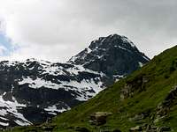
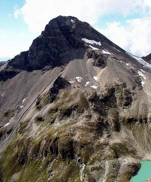
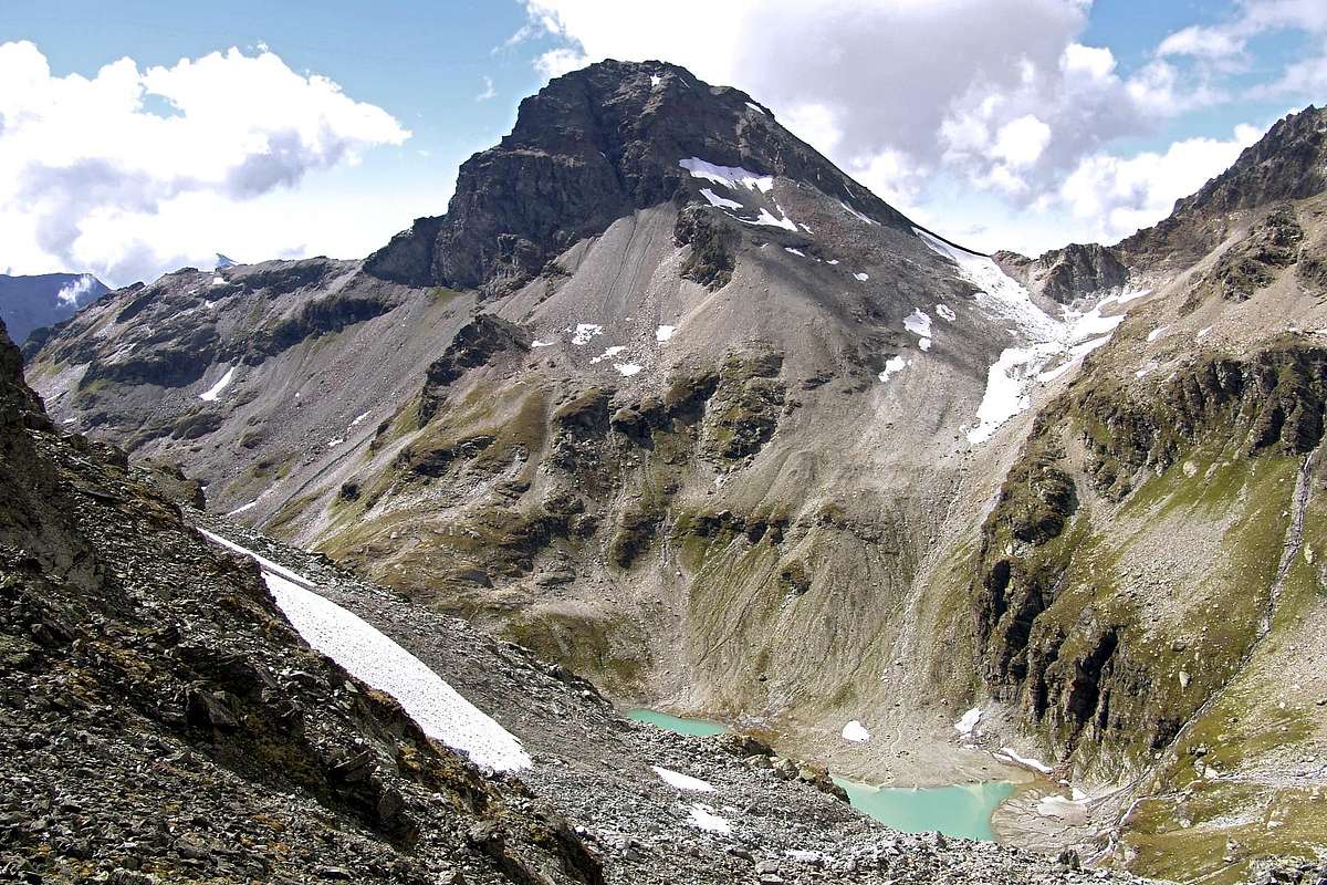
The Gran Becca du Mont he is constituted by a great pyramid rocky sited on the crest of border among Italy (East) and France (West) among the Pass of the Sachère (2.841m) to North and that of Reculaz (2.867m) to South and, more precisely, among the Walloon of San Grato of the Valgrisenche and that of Mercuel above Ste-Foy-Tarenteise (1.051m), to the beginning of the Valley of the Isère. Known also as Bec or Becca (= Peak) de l'Ane as in "Guide of the Alps Western-Graian Alps and Pennine" by Giovanni Bobba and Luigi Vaccarone, 1896, to page 188: "Gran Becca du Mont or Becca de l'Ane m 3.193. It is to thick massive isolated tower, from the steep walls, that it raises him to North of the Col du Mont;…" or, always to work of the Bobba in "Bulletin XXIV n. 57, 88" of the Alpine Italians Club: "From the Hill of Mont the watershed brusquely raises him to form to big tower of rock, the Great Becca of Mont, beyond which him lowers to another pass, the Footstep of the Sachère…." Also for Mario Aldrovandi in "Guide of the Autonomous Region of the Valley of Aosta, 1964, to page 321 deal with a rocky tower: "To Becca du Mont (m 3.193, times 4 from the Ref. Bezzi). Gigantic tower to South of the Pass of the Sassière. He can reach the peak so much from the Col du Mont, for the staircases, that for the gully that departs from the Basin of the Lake of St. Grat." Formed by four crests and as many walls, all rocky ones, possess two summits, the most elevated of which is found completely in French territory to around 150 West meters from the crest watershed; a second elevation or Antesummit East (3.158m) it is found North that climbs from the Pass of the Sachère just before to the limit of the Crest I untie it for the real peak (to right or always West). To our notice, and to have read from some part (Ouch the memory!), it is really this secondary summit of that the toponym brings Becca or Bec of the Ane (= "Beak" of the Donkey), since, it seems, that has made to climb an ass up to this point. Besides the Crest North aforesaid other three crests are addressed to South sinuous above the Col de Reculaz and the following one With du Mont (2.639m; * famous for the invasions of Italy in several Centuries by the French Army and Spanish Armada and for epic battles between the French and Sardinian amongst 1792 and 1800), Southwest and to West-northwest (Arete de Montséti) above the Réfuge de la Motte (2.030m). Limited to North by the Becca du Lac (3.402m) and from the Testa (= Head) of the Rutor (3.486m), mostly elevated of some hundred meters, introduces a splendid pano toward East on the mountainous chain that with Becca del Merlo also called Becca de Chamin, to the beginning of the Central Valley of the Stream Dora Baltea, it goes up again toward South dividing the Valgrisenche from the Valley of Rhemes with a whole series of beautiful summits (Great Revers, Becca of Tos, Pointe of the Luetta or of Tzaboc, Pointe of Felumma, Becca of Pré Damon, Becca of Laugier, Tops of Bouque) up to the great elevation, from this glacial side, of the two peaks of the Great Rousse (3.607m the Northerly and 3.577m the South one). From this point the coastline watershed still declines sloping down toward South-southwest unfolding, but more in distance, a whole series of other peaks, the most important of which it is the Great Traversière (3.496m). In the side opposite good glimpses on the Mount Pourri (3.779m), on the Great Motte (3.653m) and on the Gran Casse (3.855m), in Isère Valley.
La Gran Becca du Mont è costituita da una grande piramide rocciosa posta sulla cresta di confine tra Italia (Est) e Francia (Ovest) tra il Colle della Sachère (2.841 m) a Settentrione e quello di Reculaz (2.867 m) a Meridione e, più precisamente, tra il Vallone di Saint Grat della Valgrisenche e quello di Mercuel al di sopra di Ste-Foy-Tarenteise (1.051 m), all'inizio della Valle dell'Isère. Conosciuta anche come Becca oppure Bec de l'Ane come in "Guida delle Alpi Occidentali-Alpi Graie e Pennine" di Giovanni Bobba e Luigi Vaccarone, 1896, a pagina 188: "Gran Becca du Mont o Becca de l'Ane m 3.193. E' un massiccio torrione isolato, dalle pareti scoscese, che s'innalza a nord del Col du Mont; …"; oppure, sempre ad opera del Bobba in "Bollettino XXIV n. 57, 88" del Club Alpino Italiano: "Dal Col du Mont lo spartiacque si leva bruscamente a formare un gran torrione di roccia, la Grande Becca du Mont, al di là del quale si riabbassa ad un altro valico, il Passo della Sachère …". Anche per Mario Aldrovandi in "Guida della Regione Autonoma della Valle d'Aosta, 1964, a pagina 321, si tratta di un torrione roccioso: "Alla Becca du Mont (m 3.193, ore 4 dal Rif. Bezzi). Gigantesco torrione a sud del Passo della Sassière. Se ne può raggiungere la vetta tanto dal Col du Mont, per le gradinate, che per il canalone che parte dal bacino del Lago di San Grato". Formata da quattro creste ed altrettanti pareti, tutte rocciose, possiede due sommità, la più elevata delle quali si trova completamente in territorio francese a circa 150 metri ad Ovest dalla cresta spartiacque; una seconda elevazione, o Antecima Est (3.158 m) si trova al limite della Cresta Nord che sale dal Colle della Sachère, poco prima dello snodo verso destra (sempre Ovest) per la vetta vera e propria. A nostro avviso, e per aver letto da qualche parte (Ahi la memoria!), è proprio questa sommità secondaria che porta il toponimo di Becca o Bec de l'Ane, poiché, pare, che fin a questo punto abbiano fatto salire un asino. Oltre alla Cresta Nord suddetta altre tre creste si indirizzano a Sud, sinuosa sopra il Col de Reculaz ed il successivo Col du Mont (2639 m; * famoso per le calate in Italia da parte di Francesi e Spagnoli dal XV° al XVII° Secolo, nonché per battaglie epiche tra il 1792 ed il 1800 tra le truppe Francesi opposte a quelle del Regno di Sardegna), a Sudovest ed ad Ovest-nordovest (Arete de Montséti) sopra il Réfuge de la Motte (2.030 m). Limitata a Settentrione dalla Becca du Lac (3.402 m) e dalla Testa del Rutor (3.486 m), maggiormente elevate di qualche centinaio di metri, presenta uno splendido panorama verso Oriente sulla catena montuosa che con la Becca del Merlo, all'inizio della Valle Centrale della Dora Baltea, risale verso Meridione dividendo la Valgrisenche dalla Valle di Rhemes con tutta una serie di belle cime (Grand Revers, Becca di Tos, Pointe de la Luetta o di Tzaboc, Pointe de Felumma, Becca di Pré Damon, Becca Laugier, Cime de Bouque) fino alla grande elevazione, da questo lato glaciale, delle due vette della Grande Rousse (3.607 m la Nord e 3.577 m la Sud), Da questo punto la costiera spartiacque declina digradando ancora verso Sud-sudovest nonché dispiegando, ma più in lontananza, tutta una serie di altre vette, la più importante delle quali è la Grande Traversière (3.496 m). Nel lato opposto ottimi colpi d'occhio sul Mont Pourri (3.779 m), sulla Grande Motte (3.653 m) e sulla Grande Casse (3.855 m), in Val d'Isère.
First Ascents
- First on the summit: W.B.A. Coolidge with the Mountain Guide Swiss Christian Almer Junior, (Sep 03th, 1889).
- In winter: Unknown.
Getting There
BY CAR:
- From Torino, Milano, etc: Motorway A5. Exit at Aosta Ovest. Drive on SS.26 toward Mont Blanc as far as Leverogne (780m).
- From Switzerland: through the Grand Saint Bernard Tunnel or the namesake Pass. Drive to Aosta, then follow the direction for Courmayeur on SS.26 as previously, reaching Leverogne.
- From France: through Mont Blanc Tunnel or Petit Saint Bernard Pass. It is not necessary to take Motorway A5: you can drive on SS.26, in the direction of Aosta as far as Leverogne.Once close to the Village of Leverogne (780m), turn left if you come from Aosta or turn right coming from Mont Blanc, following along the Regional Route for Valgrisenche. Pass many small Villages, including Rochefort, La Ravoire, Chamencon, La Bethaz, and Valgrisenche (1.664m), the main center of the namesake valley. Turn right for the Village of Bonne (1.810m) located near the western summit edge of the huge dam that forms the Beauregard Reservoir, practically empty for technical reasons. Past the small Village of Menthieu (1.842m), continue for approximately 5 km along the paved road, which follows parallel to the western shore of the lake, running high above it, and then descend leading to the old Pasture of Surier (1.758m), near the Village of Usellières (1.758m) at the southern end of the lake basin. Before the village there is a ample parking space where you can leave the car.
BY PLANE:
- Aeroporto "Corrado Gex" Saint Christophe (Aosta).
Approach
From Valgrisenche
(1.664m) he continues with reaching Mondanges
(1.652m) and, abandoning her two ramifications on the left (South and East), he continues at first toward North up to the alternative
1.661 meters, where the mute road in opposite sense, and with three narrow hairpin bends on winding road reaches the Fraction of Bonne
(1.810m), near the great wall or dike's obstruction of the dam; continuing with a long South-southeast diagonal, dominating of a
150 meters the same one, the following little Fraction of Vieux-Menthieu it is reached
(1.848m), where the same continuous as in "Getting There." To abandon to right (Southwest) instead the dirt road "poderale" towards Arp Vieille and the Valley with the same placename (prohibition of transit for the cars indicative and poster in wood "Arp Vieille") continuous and through the Main Road with a long and panoramic rectilinear impending the Artificial Dam or Lac de Beauregard surpassing an Alp
1.943m under the small quota
2.015 meters, the following grouping of Breyon and reaching Rognettaz-desot to quota
1.970/80 meters around. Here, he abandons contrarily, the Regional Road that goes down wings Villages of Surrier and Usellières to the confluence of the Stream Doire de Valgrisenche with the Torrent de Grand Alpe, to take the excavated road "poderale" for the Village of Grand Alpe (
1.988 m; also here poster with prohibition of transit for the automobiles); from the pastures, to the entrance of the Walloon of Saint Grat continuous to through the same one, concomitant with the path
n° 13/14/HRG or
Tall Route Glacial and climbing side by side to the torrent to reach first the Alp of Revèraz-desot
(2.153m) and immediately after alternative the
2.174 meters, where the same one finishes only continuing with the above quoted paths. Leaving on the left (West-southwest; distinctive little bridge in the shape of arch) the
n° 13/HRG that it is addressed to the With of Mont
(2.639m) to continue instead with the
n° 14, that it goes up again the Vallon of St. Grat. Before with direction Northwest to reach the Torrent du Lac, emissary of the homonym lake and confluent of the Torrent de Grand Alpe, then with address decidedly to North on the fund of the same vallon to reach the small chapel (+;
2.466 m), positioned on the Southern bank of the Loch of San Grato (+; 2.462 m;
1h'45/2h'00).
Da Valgrisenche (1.664 m) si prosegue con la carrozzabile raggiungendo Mondanges (1.652 m) ed, abbandonando le due diramazioni sulla sinistra (Sud ed Est), si prosegue dapprima verso Settentrione fino al bivio 1.661 metri, ove la strada muta in senso opposto, e con tre stretti tornanti raggiunge la Frazione di Bonne (1.810 m), appresso al gran muro di sbarramento della diga; continuando con un lungo diagonale a Sud-sudest, dominando di un 150 metri la medesima, si raggiunge la successiva Frazioncina di Vieux-Menthieu (1.848 m), dove la stessa continua come in "Getting There". Abbandonare invece sulla destra (Sudovest) la strada poderale per l'Arp Vieille e l'omonimo Vallone (divieto di transito per i mezzi e cartello indicatore in legno "Arp Vieille") per continuare con quella pricipale con un lungo e panoramico rettilineo sovrastante la Diga Artificiale o Lac de Beauregard sorpassando un Alpeggio 1.943 m sotto la piccola quota 2.015 metri, il successivo raggruppamento di Breyon e raggiungendo Rognettaz-desot a quota 1.970/80 m~. Qui, al contrario, si abbandona la Strada Pregionale che scende ai Villaggi di Surrier e di Usellières alla confluenza della Doire de Valgrisenche con il Torrent de Grand Alpe, per prendere la strada sterrata poderale per il Villaggio di Grand Alpe (1.988 m; anche qui cartello con divieto di transito per gli automezzi); dall'alpe, all'imbocco del Vallone di San Grato, continuare tramite la medesima, concomitante con il sentiero n° 13/14/HRG o Alta Via Glaciale e, salendo in parallelo al torrente, raggiungere prima l'Alpe di Revèraz-desot (2.153 m) e subito dopo il bivio 2.174 metri, dove la medesima termina continuando solamente con i sopracitati sentieri. Lasciando sulla sinistra (Ovest-sudovest; caratteristico ponte ad ad arco sul torrente) il n° 13/HRG indirizzantesi al Col du Mont (2.639 m) continuare invece con il n° 14 che risale il Vallone di San Grato. Prima con direzione Nordovest raggiungere il Torrent du Lac, emissario dell'omonimo lago e confluente del Torrent de Grand Alpe, poi con svolta decisamente a Settentrione sul fondo del vallone medesimo raggiungere la piccola cappella (+; 2.466 m), posizionata sulla sponda Meridionale del Lago di San Grato (2.462 m; 1h'45/2h'00).
Route
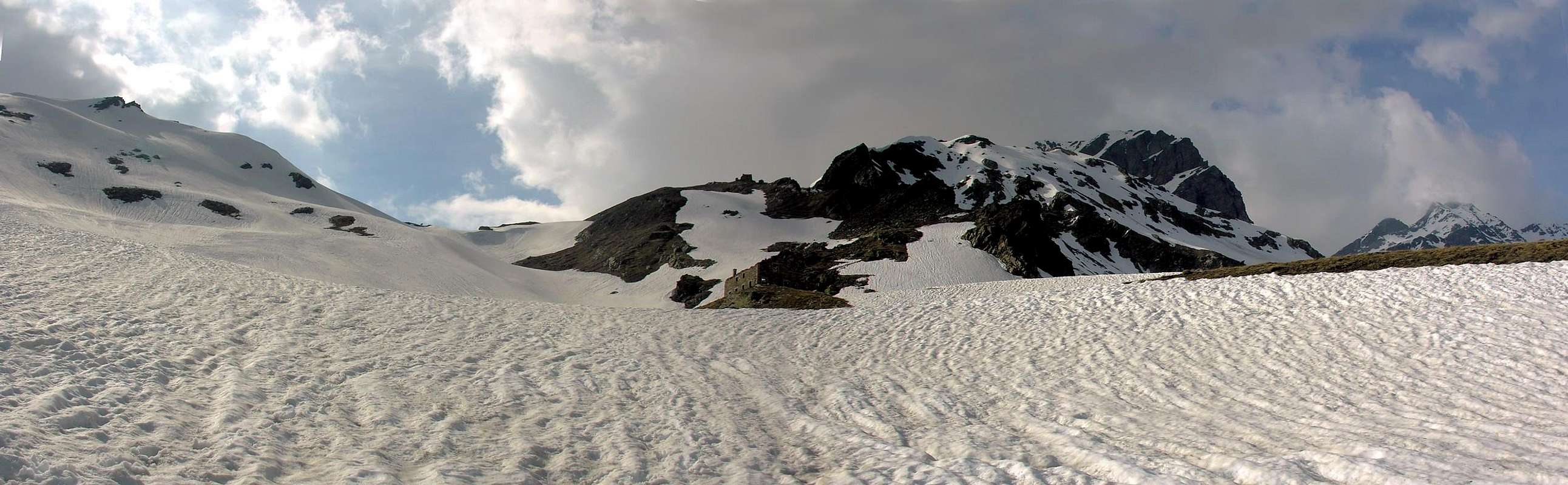
To follow a trace for brief time with direction West-northwest through grassy slant reaching quota
2.559/70 meters around, then to mostly continue toward Northwest through deposits, debris and shed blocks that conduct to the basal moraine of the rests of the Glacier de la Sachère
around the 2.750/800 meters of quota, near the effluent small torrent, and to go up again easily along the same up to the Glacier and the Hill of the Sachère, through a small diagonal slope from the right to the left (
2.841m;
1h'00; in total
3h'00 from the departure). From the hill to go himself toward South and to climb the easy Crest North that in way linear door toward a small rocky jump; to revolve to the left it toward a small snowfield in the shape of a tongue and immediately later to return on the thread of crest reaching a brief level line; two small rounded off backs conduct to a narrow and small carving, that anticipates the Oriental Top (Quota
3.158m and, to our notice, Bec de l'Ane;
0h'45/1h'00). From this continuous to still for few time toward South for then to decidedly turn to West and to cross dark with binding run, as well exposed as that asks for attention in the presence of frames of snow, reaching in around a quarter of hour the real peak (
0h'15/0h'30, according to the conditions;
1h'15/1h'30; 3h'30/4h'00 from the car).

 9442 Hits
 84.27% Score
 18 Votes