
|
|
Route |
|---|---|
|
|
16.29922°S / 71.40804°W |
|
|
Hiking |
|
|
One to two days |
|
|
F |
|
|
Overview
This is the normal route up El Misti and the trailhead is only about an hour from Arequipa by 4WD. The trailhead is at 3400 meters. A hike of 4 to 6 hours gets you to Campo Pirámides Alto at 4610m. It is then 5 hours to the summit and 2 hours descent, mostly on scree, to the trailhead.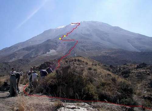 The Grau Route up El Misti.
Getting There
From Arequipa, take the old road to Puno that is used for going to Chiguata village (2987 meters), northeast of Arequipa. At about 3/4 of the distance between downtown and Chiguata (also called Chihuata), on the left side of the road, you should see the El Misti irrigation/hydraulic company complex.At this point the Misti summit should be between north and 10 degrees from north clockwise. Turn left here and pass through a gate (the irrigation company should let you in) toward the volcano and take the dust track that enters into a field limited by white walls. From here follow the rough road (there are junctions) that leads to the base of the volcano. The dirt road ends at about 3400 meters where there is a board indicating the Aguada Blanca ecologic reservation. This is the trailhead.
 Grau trailhead on the south side of El Misti. The trailhead is at 3400 meters.
Route Description
From the trailhead at 3400 meters follow the trail that continues in direction of the volcano. Later the trail crosses one or drainages depressions to catch the main rib on the left side. Once on the rib follow the trail that stays on this rib (north-northwest) up to an altitude of about 4400 meters. At this point to the left of the trail, there is low gradient traverse to a breakthrough in another rocky rib. The route then traverses over to a fairly flat area at 4500 meters.Here you find many tent platforms. The place is called Campo Pirámides.
Some people go to another camp, +100m higher on the same rib. This is considered the normal campsite now days. Here there are other tent platforms: this is Campo Pirámides Alto at 4610m (5 to 6 hours). Most people pitch a tent here. In this case, usually people start their summit bid during the night, between 2:00 AM and 3:00 AM the next morning.
 Camp at 4610 meters/15,125 feet on the Grau route on El Misti.
The route continues on the rocky rib (North) until reaching the crater. You may not find a path, especially during the night, but the main idea is to climb on the rocky rib instead of the 2 scree / ash fields on its right and left (the one on the west of the rib features the descent route). As long as you stay on the rib, there is no wrong way. Once close to the crater you traverse to the left to reach it at some kind of saddle which is the highest point of the previously mentioned scree / ash field. From here you have to go around the crater clockwise and climb about 150 meters to the highest point identified by an 8 meter high, 5 meter wide steel cross (5 hours).
 High on El Misti.
 Near the summit of El Misti.