
-
 20675 Hits
-
 84.66% Score
-
 19 Votes
|
|
Area/Range |
|---|---|
|
|
36.65970°N / 81.5447°W |
|
|
Hiking |
|
|
Fall |
|
|
5729 ft / 1746 m |
|
|
Overview
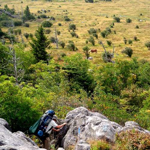
The rest of Grayson is amazing. Barren hills are all throughout the state park. Wild ponies graze in the grassy hills, and every few years they have a man-controlled fire to burn down the bushes to preserve the open areas where the ponies graze. All along this park, there are huge boulder outcrops. These are great to climb on and enjoy the spectacular views.
There is a lot of wildlife in the Grayson Highland, the most popular are the wild ponies. They roam almost every part of the more grassy areas. Sometimes you might find them grazing about near your tent. There are many tourists during the more beautiful parts of the year. When the rhododendrons bloom, which is in June. Also during the early-middle fall when all the blackberries and blueberries are ripe.
Getting There
" Mount Rogers is most easily accessed from Interstate 81. Take exit 45 at Marion onto State Route 16 and go south. Proceed a 33 miles to the junction with US 58 at Volney. Turn right (west) onto 58 and in 8 miles turn right into Grayson Highlands State Park.From I-77, take Hillsville Exit 14 to U.S. 58. Travel west on U.S. 58, 40 miles to Volney. Turn left to stay on U.S. 58 and go eight miles to the park entrance. "
From a SP member- mutant1
Red Tape
There is an entry fee per car to enter Grayson Highlands State ParkThe gate to the park is opened only from 8 a.m. to 10 p.m.
One car for the weekend during peak season, $2.00
One car for the weekend day during peak season, $3.00
Dogs must be on a leash at all times.
"All national forest trails are open to foot and horse travel except the following foot only-trails: Appalachian Trail, Mount Rogers Trail, Mount Rogers Spur Trail, Cliffside Trail, Pine Mountain Trail, and Lewis Fork Spur Trail."
SP member- mutant1
When to Hike
You can come and travel here anytime but some months are better then others depending on what kind of person you are. Because these are higher altitudes you can keep away from the summer heat. During the summer (June-August) The temperatures can range from 34 to 13 degrees Celsius during the day but most likely it will be about 24 degrees Celsius during the day. During the summer night the conditions are much cooler. The temperatures range from about 17 to 2 degrees Celsius, the average is about 14 though. I would recommend hiking in either June, when the rhododendrons bloom and look absolutely beautiful. Or one can hike during the fall when the berries are ripe. If you are more of a solitude-finder, come during the winter. Most tourists will want to avoid the freezing winds and ice-covered boulders.
Fall (September-November) Averages-
Day- 17 degrees Celsius
Night-3 degrees Celsius
Winter (December-February)
Day- 5 degrees Celsius
Night- -6 degrees Celsius
Spring (March-May)
Day- 15 degrees Celsius
Night- 3 degrees Celsius
Camping
There are very beautiful campsites all over the hills of Grayson. Some very nice ones are about 30 minutes away from Mount Rogers Peak. There are no fees or permits needed for backcountry camping. You are not allowed to camp or have campfires on the summit. The state park camping is only allowed in developed sites. Even these sites are grass-filled and have great views of the hills around. There is a shelter, the Thomas Knob shelter. I prefer to sleep on grass, but during bad weather this shelter may have to be used.Information
hgrapid - Feb 6, 2009 6:21 pm - Voted 9/10
AdditionsYou may want to borrow from the Mount Rogers page. The latitude and longitude are on that page. Add Rogers and Wilburn Ridge as children. You seem to have created this page on its own without utilizing the wealth of information already on those two pages. Add the Grayson Highlands State Park website: http://www.dcr.virginia.gov/state_parks/gra.shtml This is an alright start, but must be coordinated with the Mount Rogers page to be complete.
Wiktoria Plawska - Feb 6, 2009 6:43 pm - Hasn't voted
Re: AdditionsOkay, i have done what you said. What do you mean by "but must be coordinated with the Mount Rogers page to be complete." ? Thanks for the advice.
hgrapid - Feb 7, 2009 1:41 pm - Voted 9/10
Re: AdditionsI think you got it. There is some trip report on the Rogers page or Wilburn Ridge page about Grayson Highlands. You may want to add that as well to the trip reports list. Also, you can fix the links so they are direct by clicking on insert link in the edit page field. Also, note Make the longitude -81.54470 so the coordinates are in the U.S. Nearby areas and ranges shows that the nearest area/range listed on Summitpost to this page is in the Himalayas of Pakistan - a mere 300 miles away!!!
Wiktoria Plawska - Feb 7, 2009 8:03 pm - Hasn't voted
Re: Additionsalright then, i think i am done editing. Thank you for all your advice. Wiktoria