|
|
Route |
|---|---|
|
|
49.74982°N / 125.87257°W |
|
|
Mountaineering |
|
|
A few days |
|
|
Class 4 |
|
|
III |
|
|
Overview
Mt Colonel Foster is the most alluring summit on Vancouver Island. It's the fourth highest mountain on the Island but is by far and away the most impressive and has a great collection of outstanding, long summer and winter alpine routes between 800 and 1400m long. The climbing history of Mt Colonel Foster is relatively brief, the main summit was only reached in 1968 by Mike Walsh. The route Walsh used (Walsh's Foray) has been the de facto standard way to reach the summit since the publication of the island's first comprehensive guidebook - Island Alpine. The complete Summit Traverse is also commonly used as the main summit is in the middle of the 2km long summit ridge so it's basically the same level of commitment to cross the whole ridge as to head out and back from one end.
Despite being a very prominent feature the Great West Couloir has only recently been explored and the results are that it now presents a very viable alternative, direct way to reach the main summit. Because it reaches the summit ridge crest only a few hundred metres south of the summit it avoids much of the technical terrain encountered on either Walsh's Foray or the south half of the Summit Traverse. The couloir arcs up from a large cirque on the northwest aspect of the massif splitting the middle of the west face. It holds seasonal snow very late in the year although with the ongoing warming trends it should be expected that the snow coverage will melt out progressively earlier as time goes on.
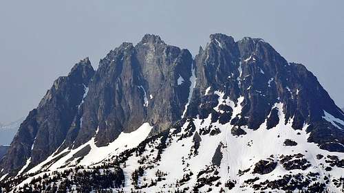
Mt Colonel Foster, West Face
Getting There
Mt Colonel Foster is reached up the Elk River Trail from Highway 28. There are three options off the ERT to reach the base of the Great West Couloir:1- via Butterwort Creek, a tributary to the Elk River. This was the original route many of the pioneers used to reach the mountain and although requires a fair distance of off-trail travel is a fairly direct way to reach the base of the couloir. Leave the ERT at the Butterwort campsite, don't wait until the bridge. Keep to the north side of the creek until in the upper, flat part of the valley, then cross to the south side.
2- via Foster Lake and the South Col - this is the most frequently used way to climb any of the high points on the massif - most summiteers only climb the Southeast Peak, which is the first high point above the South Col, via this approach. From below the base of the South Gullies, continue west traversing around the southwest corner of the massif and traverse below the west face to an obvious forested rib that connects the flat meadows of the west shoulder to the upper mountain.
3- via Elk Pass and the South Col. A longer route to the South Col than ascending up from Landslide Lake but avoids the messy rock and snow bergschrunds that can form in the south chute. From the upper part of the high valley between Rambler Peak and Slocomb's Rise hike up steep hillside on heather slopes and open granite slabs to a high basin on the east side of Slocomb's Rise. From a notch just east of the high point on the Rise find a long gully that drops off to the west. Descend the gully a hundred metres or so looking for a ledge system that breaks out to the right (north) and leads into the South Col. Traverse below the west face as described above.
Route Description
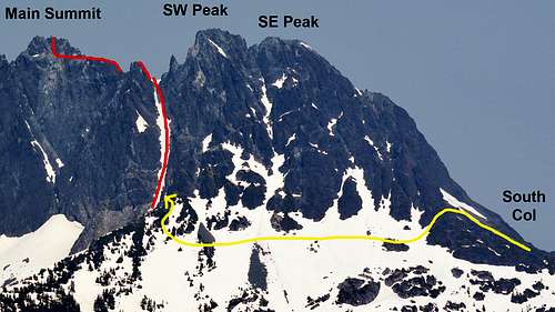
From the west shoulder or traversing from the South Col gain the base of the couloir proper. Keep to the treed rib above the west shoulder and find a narrow ledge that links the rib to the couloir just where the west face begins to rise above. With snow cover the couloir is an easy ascent up about 300m of moderate angle (40˚) snow. Depending on seasonal snow cover and time of year the snow may melt out, these conditions haven't been recorded yet but it's anticipated there would be considerable scree/talus exposed.
Toward the top the couloir narrows to a bottleneck with a final 50m step at 4th class rock or 45˚ snow and exits into a narrow col below the Corporal Gendarme on the summit ridge. Follow the summit ridge traverse north to reach the main summit. Full details in the Island Alpine Select eBook.