
|
|
Mountain/Rock |
|---|---|
|
|
47.39083°N / 14.53944°E |
|
|
Steiermark (Styria) |
|
|
Hiking, Mountaineering, Scrambling |
|
|
Spring, Summer, Fall |
|
|
7667 ft / 2337 m |
|
|
General Survey
 View from the mountain
 Flora
Flora Map Overview
the nordwesternmost range of Seckauer Alps.
Because of it's almost outposted position on the Triebener Tauern ridge (Triebenerkamm),
this summit made of mixed granite slabs and thick grass does offer extensive panorama views over the Niedere Tauern range.
Grießstein is also acknowledged as ski tour destination.
The easiest way to the summit over the NW ridge can be divided into two parts:
I - Trieben valley (Triebener tal) to the Trieben pass (Triebenertörl)
- around 2 hours and 1200m/5900ft of altitude difference
II - Trieben pass to the summit - around 1 and half hour and 430m/1400ft of altitude difference
I - From the Sayfried, follow yellow waymark no.949 for Triebenertörl, first over the meadows,
then uphill through the woods.
Halfway, you'll find the water source, just in case you have forgot to take it with you.
As path reaches above the treeline, it does steepen a bit, but no technical difficulties whatsoever.
And after some 2 hours you'll find yourself on the Triebenertörl pass.
Triebenertörl is pretty, flora rich and grassy pass lacated between valleys of Bärental and Triebental
and summits of Grießstein and Sonntagskogel.
It is worth to have stopover here, as the pass itself does offer nice overview of the Triebener range mountains,
as well as beautiful panoramic view toward Gesäuse part of the Ennstaler Alps,
with Buchstein, Admonter Reichenstein and Admonter Kalbling competing for your attention.
II - From here goes more serious, path steepens over the loose slabs (in case of fog, could be tricky)
and it takes few passages where moderate scrambling skills and surefoot is mandatory.
Reward after 90 minutes is the summit cross on Großer Grießstein
- must be windy place as the cross itself is fixed with numerous iron ropes.
Panoramic views in all directions.
Return the same way.
After good two and half hours, you'll be again next to your car.
Maybe short subchapter on the parent Seckauer Alps range:
Radstädter Tauern, Schladminger Tauern, Rottenmanner & Wölzer Tauern
and Seckauer Tauern together, form the Niederen Tauern range.
Seckauer Tauern is the easternmost group of the Niederen Tauern.
It is limited by the valleys of Ingeringbach and Liesing.
Highest summit is Geierhaupt (2.417m)
Triebener Tauern is the northwesternmost part of Seckauer Tauern,
axe of the Triebener Tauern is the 1274m high Triebener Tauern mountain Pass
that crosses the Niedere Tauern and connects the Mur River valley near Judenburg
with the Palten River valley near Trieben.
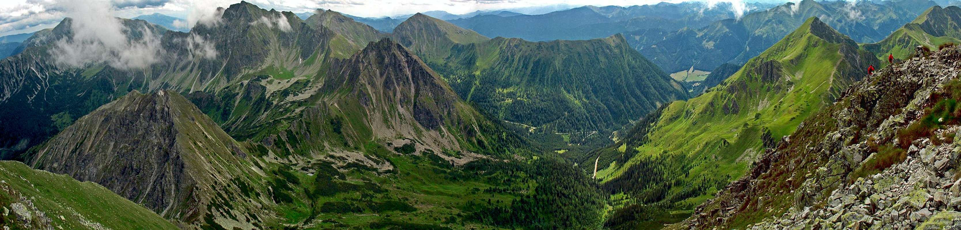
Panorama view from the summit
Panorama in original size
Getting There
 Road map and rute detail
From Germany: via München-Salzburg oder Nürnberg-Passau
From Vienna: Südautobahn-Semmering from St. Michael over A 9 to Trieben or via S 36 direction Judenburg.
From Graz: Motorway A9 due Salzburg, take off for Trieben, regional road B113 due Hohentauern,
at Hohentauern fork for the Vordertriebental valley and drive till the Sayfried village (1117m/3670ft).
Park somewhere at the end of the village and look for the well marked path on your right.
By train or coach:
Railway route Selzthal-Trieben, or. St. Michael-Trieben.
Trieben is the nearest train stop Austrian railways connection search
Nnearest postbus stop is Gasthof Brodjäger Postbus search site
Air transport:
By plain: nearest intl airport is Graz Flughafen
( this airport is also served by various low cost carriers like RyanAir)
Camping & Huts
 Nearest Hut location
As Grießstein can be done inside half day, staying in the hut is not common, though.
Triebentalhütte, 1.104 m
OeAV Sektion Akad. Sektion Graz
18 bunks unshielded, open only after the announce one's visit
Contact info:
hut warden
Willibald Zich
Bergstrasse 44
A-8020 Graz
phone (hut warden): +43 3618 268
phone (hut): +43 316 575156
fax: +43 316 81247415
Nearest train stop is Trieben , nearest postbus stop Gasthof Brodjäger.
Postbus search site
Austrian Railways
Geting there by car is described above in the Getting There chapter.
Apart from Grießstein, hut may be but doesn't have to be
combined with ascends of Gamskögl ( 2.365m) and Geierkogel (2.237m)
Weather Maps & Security
 Helpful publications
from wetter.at (German)
Avalanche info service Styria (German)
Webcams:
none of the webcam chiefly shows our mountain,
but several are inside reasonable distance:
Hohentauern
Ennstaler Alps
Maps:
freytag & berndt WK 212 Gebirge / Gebiet Triebener Tauern
Kompass 222 Rottenmanner Tauern, Wölzer Tauern, Triebener Tauern
Security: Mountain rescue service, dial 140