
|
|
Route |
|---|---|
|
|
43.66900°N / 114.094°W |
|
|
Hiking, Scrambling |
|
|
Spring, Summer, Fall |
|
|
Half a day |
|
|
Class 3 |
|
|
Loose Scree |
|
|
Overview
Grays Peak is easy to access and a pleasant trail leads to its upper reaches. Once at the upper reaches, 1900 feet of scrambling up scree slopes awaits. Gully #2 is a way to climb where the scramble is harder than on the standard route, but is more direct. While this Gully is unnamed, it is the second gully noticeable along the Federal Gulch Trail (and the most prominent) while hiking the trail below the upper slopes of Grays Peak. Depending on your condition, acclimation, and experience with climbing up loose scree, this hike will take you anywhere from 2 1/2 to 4 hours to the summit.Getting There
The directions are the same from the front page to the Federal Gulch Campground (CG). This is where you park. The trail is obvious. Grays Peak from the East Fork Road
Route Description
From this point, the best option is to take the Federal Gulch Trail for about 3 miles until you reach a green meadow mostly above the trees. At this point, you are still on the Federal Gulch Trail, and Grays Peak will be visible in the distance. Grays Peak from just above the meadow
Soon after reaching the ridge you will see a sign. The sign is not a point where you change direction, but is a landmark worth noting. At the sign, you simply continue on the Federal Gulch Trail below the base of Grays Peak (at about 8600 feet). The Federal Gulch Trail heads towards a ridge on the East side of Grays, with only a slight incline. You will not go as far as the ridge. Instead, you will go about half way (about 5-10 minutes) until you see a noticeable gully that is about 5-6 feet wide and head directly up the mountain.
The gully starts at a little over 8600 feet and tops out at roughly 10,300 feet, very close the summit. Parts of the gully are difficult and steep, but stay in the gully, because the sides of the gully contain looser rock, and less forgiving terrain. Through most of the climb, you will need to scramble quickly up the rocks to gain traction. After you gain a few hundred feet, you will see a small rock pyramid sitting far above you on your left side. This is your target. You need to reach the top of this small pyramid before you can reach the final stretch of the summit ridge.
 The long gully coming from the Federal Gulch, 1800' feet down
To descend, take the main summit ridge back down to the meadow near where you originally came out of the woods. You should go as far as you can on the ridge to the lowest point of elevation that is still connected to the meadow below. Any other way down is too steep, and makes the descent far more difficult. The gully is probably too treacherous for a descent.
The total distance of this hike is about 7 miles, with gains of over 3,700 feet. It can take anywhere from 4 1/2 hours to 7 hours.
Essential Gear
In late fall, winter, and early spring, this gully will be covered in snow and ice, and will require crampons and an ice-ax. During the summer, form-fitting gloves are recommended along with good hiking shoes and lots of water.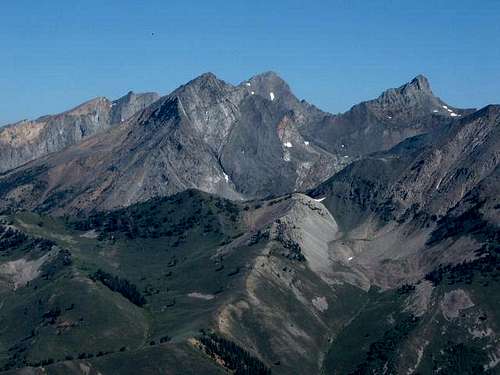 What a view from the summit!