
|
|
Area/Range |
|---|---|
|
|
48.08732°N / 15.91460°E |
|
|
Hiking, Sport Climbing, Toprope, Via Ferrata |
|
|
Spring, Summer, Fall, Winter |
|
|
2930 ft / 893 m |
|
|
Overview
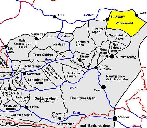
The Wienerwald (Vienna Woods) is the most eastward and northern part of the alps and consists of low mountains - mainly wooded.
The borders of the Wienerwald are the rivers (Danube) - Traisen - Gölsen - Triesting - Danube. Vienna (the capital of Austria) is partly surrounded by the Wienerwald and an important recreational area.
 |
|---|
Important natural parks
- Lainzer Tiergarten (located in Vienna) and
- Naturpark Föhrenberge (pine mountains)
Mainly sandstein and some limestone (e.g. Peilstein, Thalhofergrat, climbing areas in Baden, Mödling )
The highest elevation in the Wienerwald is Schöpfl (893m) above sea level.
Climbing, Hiking, Caves + Mountain Biking
see the link section for more information
Climbing Areas close to Vienna (Kaltenleutgeben Valley):
Mizzi Langer Wand and Lutterwand are the closest climbing areas near Vienna (Mizzi Langer Wand is part of Vienna, Lutterwand is on the opposite side of the valley)

Climbing Areas near Mödling:
 Roter Ofen - Hinterbrühl(near Mödling) Roter Ofen - Hinterbrühl(near Mödling) |  Climbing at Efeugrat Climbing at Efeugrat |  Glocknergrat Traverse Glocknergrat Traverse |
|---|
Climbing Areas near Baden:
 Engelstein Engelstein |  Jammerwandl Jammerwandl |  Jammerwandl Jammerwandl |
|---|

Peilstein Area:
 Peilstein from Thalhof Peilstein from Thalhof | 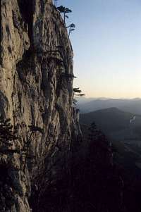 Peilstein - Gr. Peilsteinwand Peilstein - Gr. Peilsteinwand |
|---|

Via Ferrata
 Mödlinger Klettersteig Mödlinger Klettersteig |
|---|

Hiking:
 near Baden near Baden |
|---|
Wiener Hausgebirge: Vienna’s Home Mountains - covers only a very small part of Wienerwald - Wienerwald mountains located in Vienna.
Caves:
- Allander Tropfsteinhöhle (stalactite cave) near Alland
- Dreidärrischenhöhle near Gaaden
- Seegrotte - A former gypsum mine that was flooded after blasting in 1912. It remained closed until the 1930's when the subterranean lake (the largest in Europe) was discoverd. In World War II airplanes were produced by concentration camp prisoners. After the war Seegrotte was reopened.
Mountain biking:
Some dirt roads are open for mountain biking - Moutainbiking in Wienerwald
Getting There
Some parts of the Wienerwald can easily be reached by public transport (nearly every part in Vienna, areas near the Austrian Southern Railway around Mödling and Baden)
Areas like Peilstein are quite difficult to reach by public transport.
Red Tape
Lainzer Tiergarten is surrounded by a fence and some gates are closed in winter.
External Links
Sorry all information in German
Climbing links
Keltenkalk (Guidebook) climbing areas from Vienna to Semmering
links from www.bergsteigen.at
- Lutterwand near Vienna
- Efeugrat - near Mödling
- Jammerwandl - around Baden
- Peilstein
- Thalhofergrat
Mountain biking
Books etc.
Keltenkalk (Guidebook) climbing areas from Vienna to Semmering
Kletterfelsen rund um Wien by C. Hacker and K. Schall (out of print)
Kletterfelsen von Wien bis Semmering by Christian Hacker (out of print)