
-
 2022 Hits
-
 74.92% Score
-
 5 Votes
|
|
Route |
|---|---|
|
|
46.63518°N / 10.50790°E |
|
|
Hiking |
|
|
Summer, Fall, Winter |
|
|
Half a day |
|
|
Hike |
|
|
Overview
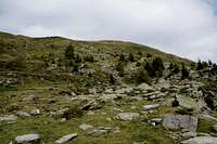
 Right beneath the south ridge of Plaschweller Right beneath the south ridge of Plaschweller |
The route from Lichtenberger Höfe / Malghe di Montechiaro through Gutfalltal to Dorferalm, the climb to the south ridge with the following traverse is the longer of the two routes which start at the same trailhead. But for the final traverse across the west slopes of the south summita nd the short scramble to the main one the whole route is a rather easy and uncomplicated hike. There are some orientation issues in the lower part but once above the timberline all ambiguity ends.
On the other hand, the route through Gutfalltal is the less popular of the routes, resulting from the fact that most summiters will also head for Glurnser Köpfl / Monte di Glorenza and thus opt for the shorter route. It is also part of the Piz Chavalatsch / Monte Cavallaccio normal route in which case the ascent of Plaschweller is usually skipped.
Getting There
See the main page for the GGetting There information.Route Description
 Cascading Gutfallbach Creek
- Start altitude: 1550m
- Summit altitude: 2534m
- Prevailing exposure: South-East
- Type: Easy Hike, Scramble on the ridge
- Protection: None
From the small parking lot at Lichtenberger Höfe / Malghe di Montechiaro follow the road for a few metres before turning lleft and heading up the north slopes of Gutfalltal. The path levels out and soon reaches an intersection (Tschagainhütte Route to the right) which you ignore. The path leads into the valley, crosses to the other side ofer the (beautifully cascading) Gutfallbach and finally reaches a dirt road which leads to Dorferalm, a small farmstead at the end of the valley.
 |  |  |
At the Alm a trail leaves the road heading steply up the Plaschweller south slope and heading for a saddle between the mountain and neighbouring Piz Chavalatsch in many switchbacks. In the end the slope gets very steep but shortly before the final traverse to the saddle a narrow path turns off to the right. There is a barbed wire fence which has to be crossed several times until you reach the summit. Finally the path reaches the ridge to the south of Plaschweller's south summit.
 | 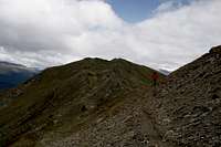 | 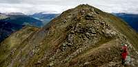 |
It passes to the north-west of the south summit in a long slope traverse. Again the barbed wire fence needs to be crossed before you can head down into the saddle between the two summits. Descent and ascent are steep scrambles on loose rock, a bit exposed to the western side.