The Ascent
Peavine Peak is a long hike anywhere from paved roads. The hike took me 5 hours, which is a long time considering it is supposed to be a 10 mile hike with less than 3,000 feet of elevation gain. I ended up hiking about 12 miles to avoid a steep snow slope.
The trailhead to Peavine Peak is about 12 miles from my apartment in Reno. The first time I visited the peak, I did not climb the entire way up. I just hiked up for about an hour to see the way up so I would be more certain about where I was going the next time.
I returned several weeks later on March 18th, 2007. Kind of in a bad mood, I wanted to get this peak completed. I see it everyday and because I am looking forward to hitting Tahoe area peaks in the next few months, I wanted to knock off Peavine to ensure that I had the stamina to climb those mountains.
From the trailhead at the end of Hopi Lane, I hiked the same way I had the last time. For 2 miles I hiked the same trail, until I hit the spot where the first big incline comes in. Last time, I took this incline, but this time I followed another way. The reason was because I had a hiking book with me that indicated the other way to go was around the hill to the right, and then hit the Peavine summit road.
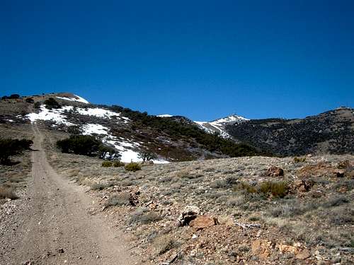
I headed down to the Peavine Summit Road until I could find a way to hit the steep gully up to the summit ridge. Now the REAL hiking began. This gully is very steep, with power lines overhead. It is really a road, but in early spring it felt more like a gully because most of it was covered in snow. Not steep snow, but snow nonetheless. This road is just under half-a-mile to the ridge, but you gain about 150 feet for every tenth of a mile.
![Take this trail to the summit ridge]() The gully to the summit ridge in red
The gully to the summit ridge in red
Half way up, I heard shooting in the distance. The shots fired became louder and more frequent. I realized that I had a real chance to get shot. As ammunition fire filled the air, I had no choice but to yell ahead. “Hey, hiker, don’t shoot!” No response. Apparently these shooters were either far away, ignoring me, or just a bunch of a-holes. Whatever the case, I took some more steps forward, stopping every 15-20 steps, continuing to voice my presence. Although I never heard any response to my yelling ahead, the shooting finally subsided. I reached the crest of the ridge only to see an SUV parked on top of the ridge. They had obviously taken the Peavine Summit Road around the ridge to get there. I asked them if they were the ones shooting, but they told me they were not. The shooters were nowhere to be found. At least now I was safe. I just had 1 mile to go and 1,000 feet up.
![Heading for the summit]() Heading towards the summit on the summit ridge
Heading towards the summit on the summit ridge
Now I took the steeper, shorter way directly to the summit. First there was no trouble. I just hiked up a steep jeep trail. But then I ran into snow. The snow got progressively steeper. My whole foot sunk into the snow up the slope. It was getting tougher as I went along. Then, finally there was a respite. The trail leveled off, and the snow was gone. I didn’t have much more to go.
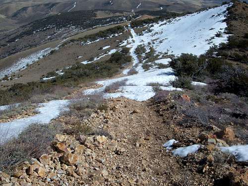
![Looking down the summit ridge]() Looking down the summit ridge on the descent
Looking down the summit ridge on the descent
I reached the summit without much trouble. It has a lot of electrical equipment, but you can reach the real summit. Of course, there is also a twin summit one quarter mile away. The twin summit is about the same height, although the first summit is supposedly the highest. I decided to swing by the twin summit anyway to see the view.
The view, the descent, and reflections
After all I went through, the view from both summits really weren’t too rewarding. Although it is cool to have a wide view of the surrounding area, Mount Rose blocks any view to the Lake Tahoe and you can’t see Pyramid Lake. Still, there is a full view of Reno and the mountains to the east.
[img:279266:aligncenter:medium:Looking down the summit ridge on the descent]
On the way down, I treaded through the snow and the steep slopes. Rather than take the steep slope down the power lines I took Peavine Summit Road. The rest of the way down was just a lot of walking. I walked and walked for nearly 7 miles back down to my car.
Whatever was in bloom for Spring caught my sinuses and I was sick for the next week.
However, I still say that despite everything the hike was worth it. Now the mystery of the mountain to the north was solved. I had seen what I could see, climbed what I could climb, and photographed what I could photograph. I doubt if I will ever climb Peavine again. I may do some biking up there though. Now, Tahoe awaits!


Comments
Post a Comment