

Comments
No comments posted yet.
|
|
Trip Report |
|---|---|
|
|
46.01677°N / 114.3567°W |
|
|
Aug 3, 2020 |
|
|
Mountaineering, Scrambling |
|
|
Summer |
Being new to Missoula and the Bitterroot Mountains, Jason and I were excited to get out and explore. While perusing Summitpost for new peaks to climb, we stumbled upon the High Five, and thought it'd be a fun idea to attempt what seemed to be one of the hardest Bitterroot linkups in our first summer. Little did we know what we were getting ourselves into...
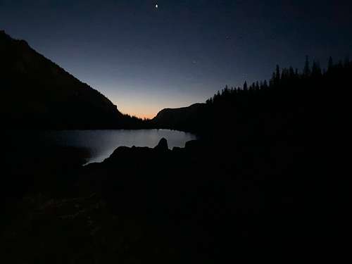
After a few hours of sleep in the truck (more than 2 before an alpine start feels like a dream), we embarked on our journey at 2:15am. The Little Rock Creek trail was better than expected, and we arrived at Little Rock Creek Lake by 4:30am. After a quick snack break and filling our water bottles, we begrudgingly began the notorious bushwhack to the upper lakes. We paved our own path by staying just East of the creek, and were unable to find any climbers trails. Many a curse word was spoken during this portion of the day, but we finally reached the lakes.
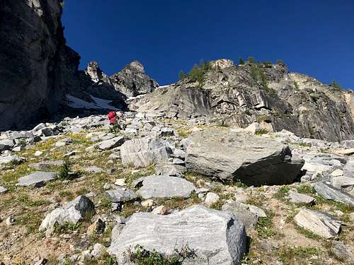
It should be noted that this bushwhack lived up to its reputation, as we discovered upon reaching the higher lakes that I had lost an approach shoe that had been stashed in the side pocket of my backpack. Left with my trail runners and one approach shoe, I decided one is better than nothing, and proceeded to wear one approach shoe and one trail runner for the rest of the day.
The couloir was mostly snow free, but there was a steep bit of snow remaining at the top requiring an ice axe and some sketchily kicked steps in aforementioned trail runner.
Once we gained the ridge, we noticed how tired and beat down we were after miles of bushwhacking through the dark. Right before reaching the summit, a rumbling sound in the distance alerted us to a massive rock slide coming down from the Southwest slopes of Lonesome Bachelor. We stood awestruck for what seemed like minutes as rocks came crashing down the face and dust rose into the sunlight. This seemed a foreboding sign, so we agreed to reassess our plan at the base of Lonesome Bachelor.
We proceeded up El Capitan, and upon reaching the summit at 9:45, felt the exhaustion of a full day's outing.... only we were just at the beginning.
We descended and began the long, talus trudge across the massive saddle spanning El Capitan and Lonesome Bachelor. We decided to continue and mitigate the risk of rockfall by quickly traversing below the Southwest face of Lonesome Bachelor, trying to stay well below the cliffs. We held our breath as we crossed the path of fresh, unconsolidated rock shifting beneath our feet, but thankfully made it across swiftly and safely to the South ridge.
Once at the base of the South ridge, we began scrambling up the 3rd class sections. Upon reaching the upper crux pitches, we decided to break out the rope, as we were having difficulty finding sub 4th-class terrain. Jason led up the dihedral pitch and an easier blocky arrete above this to the right, and we scrambled up the summit block at 1:15. Eager to get back down off of this exposed and ominous peak, we didn't spend much time on the summit before descending, as we had taken much longer than expected to summit the alleged crux of the ridge.
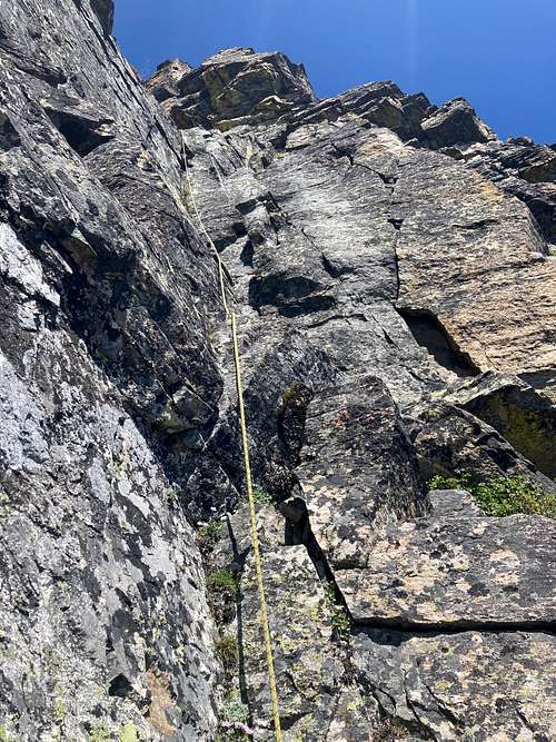
After downclimbing a small dihedral on the Southeast side of the ridge, we decided to use the rope again, slinging a large block and rappeling down the lower cliff bands. We were thankful to be on our way, on what we thought would be the final long push on the ridge from Lonesome to West Como before things got easier. Here, I aimed for a low traverse in order to cut any extra elevation by following the ridge directly, but lost sight of the ridge along the way and became disoriented. By the time I turned North to gain the ridge, we had bypassed West Como and had to angle Northwest to gain the peak. Summitted West Como at 4:45.
The ridge from West to Middle Como peak was the most gloriously straightforward section of the entire day. Consistent 3rd class scrambling brought us up the ridge of Middle Como to the summit in 40 minutes, summitting by 5:50. I was really starting to feel the exhaustion and stumbled several times on my way up the peak, and took a breather up top to try and overcome my exhaustion and impending sense of doom.
From the top of Middle Como, the ridge continuing to East Como looked impassable with numerous towers and gendarmes. Hoping that it was actually easier than it looked, we descended Middle and decided to stick to the ridge as much as possible for the final ascent. However, as soon as we reached the blocky tower before the ridge began ascending, the routefinding became much more challenging and it was hard to find a passable route without extreme exposure. We used the rope for a couple of sketchy traverses, and several times ended up dropping to the South side of the ridge to skirt gendarmes. Unfortunately each we time left the ridge, regaining it proved difficult. The exhaustion of the day and the waning daylight made this one of the most stressful portions of the climb. Finally, we reached East Como's summit at 8pm, just before sunset, and breathed a sigh of relief. Just one more boulder field, we'd hit treeline, navigate the cliffbands using the beta scrounged from trip reports, and we'd be back on the trail before midnight.... right?
After bagging the final summit of the day, we began descending the East ridge, encountering obstacles that forced us to skirt to the South of the ridge. We finally reached the point of the ridge from which we would descend into the basin. Talus turned into bus sized boulders as we aimed towards the Western edge of the basin. Unfortunately, the last hint of daylight left as we reached treeline, leaving us nervous about finding the gully through the cliff bands that we had read about. The bushwhacking turned thick and we eventually stumbled upon (but thankfully not over) a cliff. At this point it was too dark to navigate so we rappelled off of a tree. More steep bushwhacking led us to another shorter cliff which we were able to downclimb through a chimney, losing a trekking pole in the process. The next few miles seemed indefinite, with steep bushwhacking, more talus, dwindling water reserves, but thankfully no more cliffs. An eternity later, we finally reached the trail and rejoiced-- it was the first time we had been on a trail (or even flat ground, for that matter) in at least 18 hours. Our bushwhack linked up to the trail about 3-4 miles from the trailhead, which was farther than we had hoped, but we were in good spirits now that we were on trail and had water again. Even the final uphill "stinger" couldn't get us down, and we were back at the truck by 1am. 23 hours and we had completed the High Five!
Though this might be the SKT (slowest known time), I thought we might be able to claim the title of "first successful High Five Traverse completed by a couple in their first summer in Missoula." If anyone knows otherwise, please post here!
Link to video of our High Five trip here: https://www.youtube.com/watch?v=OpKMauvYvnU