Introduction
Sometime in August of 2006
Peter and I began corresponding via PM. Through those PM’s we learned that we had similar interests, such as a love for the Sierra Nevada Mountains and Sierra Nevada Pale Ale. We also learned that we had pretty much the same skill level.
After a month or two of corresponding, we decided to attempt
Mount Shasta in late June, 2007 with a warm up climb of
Dunderberg Peak in April. As April, approached we invited my best friend
PJ. I have known PJ for close to twenty years. We met in the Boy Scouts, we played in-line hockey together while in high school. We have shared many outdoor adventures like a trek through Yosemite and the southern half of the John Muir Trail. I was PJ’s best man at his wedding, so naturally he was the best man at mine. And almost as important: PJ loves Sierra Nevada Pale Ale.
On April 27 PJ and I drove up to the Honeymoon Flat campground near Twin Lakes outside of Bridgeport to meet Peter for our
attempt of Dunderberg Peak. Peter turned out to be a really cool dude and we had a great time that weekend. Friday night we drank beer and got to know each other. On Saturday, we climbed up to Moat Lake and set up camp and practices self-arresting and climbing in the snow. Sunday we got a late start, and after an hour of climbing I kicked a rock loose that hit Peter in the knee. We then decided turn back. Although we were not successful in summiting Dunderberg Peak, we felt that we were ready for one of the
easier routes on Shasta.
As June approached it became clear to us that there wasn’t going to be enough snow for a fun climb up Shasta. So we began to think of alternatives. Since Peter had already bought his plane ticket to Sacramento, we decided we should do something in the Tahoe area. We finally decided on
Mount Tallac ,
Dicks Peak , and
Jacks Peak . But with one week to go, the
Angora Fire broke out near South Lake Tahoe. Not wanting to be near a fire, we had no choice but to change our plans again. So with a few days to spare, we decided on
Highland Peakand
Silver Peak in the Ebbetts Pass area.
Getting There Is An Adventure In Itself
Finally June 30th rolled around. All of our planning was at an end and we were finally going to get to do some climbing. But first we had to get up there. My wife Milinda, my daughter Abigail and I picked Peter up at Sacramento International Airport at 7:30 in the morning. And to Milinda and my shock, Abigail took an instant liking to Peter. I knew right then that this was going to be a great trip.
After introductions were made and Peter had claimed his backpack, we left the airport to meet up with PJ at his home in downtown Sacramento. We had to print out maps on PJ’s printer because I was out of paper, but as it turned out he was out of ink. So we had to take some of PJ’s paper and drive to my place to print out the maps. It’s amazing how things work out like that, because as soon as we walked through the door, we saw my boots on the floor.
At 11:00 am we piled into PJ’s car - we were on the road at last. We took Interstate 5 south to Stockton and then took Highway 4 east. Before leaving Stockton we had to get gas. Of course we picked a gas station in the ghetto, which might have been the scariest part of the trip. As we drove from Central Valley to the foothills to the mountains, we drove through the towns of Copperopolis, Murphy’s, Arnold and Bear Valley. We talked about our jobs, wives and sports and we listened to U2, Arcade Fire, and The Dave Matthews Band. At 2:00 we reached Ebbetts Pass where our trailhead was located.
The Trek To Highland Base Camp
We emerged from the car into a windy and cool mountain environment. It is always nice to get out of the car after a long drive and this was no exception. We spent about a half an hour finalizing our gear and splitting up the food and by 2:30 we were on the trail. A quarter mile down the trail we came upon the junction with the Pacific Crest Trail (PCT) and we took the PCT south towards Noble Lake.
The PCT in the Ebbetts Pass area is a really pleasant hike. The trail was pretty well maintained and it was never too steep. There are great views, in addition to plenty of shade. In a normal snow year, I’m sure there would have been plenty of water. The area seemed more volcanic than the rest of Sierra Nevada. While Yosemite and Sequoia/Kings Canyon are mostly hard granite the rock we saw was definitely lava. Peter said it reminded him of pictures he has seen of the Rockies.
We hiked a strong pace and we reached our first day’s goal of Noble Lake by 3:45. Right away we found a nice campsite right on the north shore. But considering how windy it was and it being right on the lake, we figured it would be a cold night so we moved on. We followed the PCT a little further a little past Noble Lake and we went into a group of trees.
Inside that little group of trees is perhaps the best-kept secret in the Ebbetts Pass area. There was a 30 by 30 foot flat clearing. In the center was an established fire ring complete with firewood and log benches. There was plenty of flat ground for tents. And the trees did a pretty good job of blocking the wind. From the benches at the fire ring you can look north and see Noble Lake 200 feet away and Freel, Jobs Peak and Jobs Sister. We had defiantly struck gold with this site.
Night One
Well since we found ourselves a killer campsite we then set about setting camp. We used the tarp that we planed to use as a shelter in case of rain for a wind block. PJ then went on a walkabout for more firewood while Peter and I went down to the lake to fill our Nalgene bottles and the bear canister with water. The three of us then met up in camp and had a “gourmet dinner” of Mountain House Lasagna, mmmm salt.
After dinner, we all cleaned up the dinner mess. Realizing that we still had plenty of daylight, Peter and I climbed up to the top of a bluff that overlooked Noble Lake to see if we could find the trail we would use the next morning for our climb. From the top we saw the route we would take to top of Peak 10,824 but we were unable to find the trail. From the top of the bluff the views really opened up. To the north we could see
Freel Peak,
Jobs Sister ,
Jobs Peak, Monument Peak and
Mount Rose Mount Rose. Looking east, Peak 10,824 dominated the view with Silver Peak just to the north of it. When we looked south
Tryon Peak stood out.
With our recon mission semi-successful we made our way back to camp. Peter and PJ explored the area around Noble Lake, while I hung out in camp and got my sleeping bag and mattress ready. Peter and PJ returned shortly after with stories of a
beautiful meadow . By this time it was getting on to 8:00 and the sun was sinking in the sky. The three of us climbed up to the top of the bluff to catch the sunset. And what a sunset it was. With lenticular clouds hovering over the Carson Range and the smoke from the Angora Fire, the sky went from a deep blue to orange-pink to purple.
Then, suddenly, the sun sank below a ridge and we were in the shade and the temperature dropped 10 degrees in a matter of seconds. It was then that we remembered the large fire ring that was ready to go. With that motivating factor, we quickly made our way down the bluff and back to our campsite. Peter and I stuffed all of our food into the bear canister while PJ did his usual bang up job of getting the fire going. We sat by the fire for the next hour or so and finalized plans for the next days climb.
Sometime around 9:30 the wind shifted and started coming into the campsite a lot harder. With embers flying out of the pit we made the painful decision to put out the fire. With the Angora Fire raging in nearby Tahoe we did not want to start another forest fire. With the fire out and the wind blowing hard, we found ourselves cold and up late. It was definitely time for bed. I’m not sure what time it happened but sometime during the night a bright light woke me. At first I thought the sun had arisen, but after a few moments I realized that is was the moon. An almost full moon had traveled directly over a campsite and it lit up the whole area. I could clearly see Noble Lake and the surrounding mountains. It was a surreal experience and one I hope to experience again.
Finally Some Climbing
I awoke to the sound of voices and as I emerge from the bottom of my sleeping bag I was shocked to see that the sun had just risen. As usual I was the last one up and I had slept in to 6, so much for that alpine start. After a quick coffee and Clif bar breakfast we packed our backpacks and did a quick camp clean up and we hit the trail by 6:45.
We started out by hiking south on the PCT until we reached the top of the bluff. We left the PCT and hiked cross-country towards a small lake that Peter and I found the evening before. We figured we would find the use trail there and we would fill up our water bottles. As we wandered around up they’re we for almost 10 minutes looking for the trail. We finally found it coming out of a good-looking campsite on the north shore of the little lake.
The trail headed north from the lake through a forest. It was well marked in some spots and almost non-existent in others. At one point we realized that we were no longer on the trail a decided it was useless to try and find it. We could see the first saddle and we knew where we were going so we headed straight towards the saddle.
At first the going up was good. It was mostly solid rock and we made quick good time, but after a while the rock gave way to sand and talus. The sand was the type where you take one step just to lose two. This is definitely not the best stuff to climb up.
We climbed up sand and the occasional rocks, some of which I kicked down towards Peter causing him to have some nasty flashbacks. After almost an hour we topped out and to our surprise and relief we were a lot higher up the saddle then we planed. After a short break we started climbing up the ridge to Peak 10,824. For the most part we followed a trail or many trails, because there was a maze of trails that headed up the ridge. Here and there we found some minor class 3 rocks which we took advantage of to make the climb more interesting. We climbed for an hour before we got to a saddle right under the summit of Peak 10,824. It was here that we got our first view of Highland Peak since the hike in on the PCT the day before.
![Highland Peak]() Highland Peak From The Saddle Just Below Peak 10,824
Highland Peak From The Saddle Just Below Peak 10,824
It was really windy on top of the saddle, so we continued to hiking down the other side of the saddle to find a protected spot for a break. During the break we broke out the map to get names to some for mountains we could see to the south. We were able to see the Sonora Pass area and we noticed Dunderberg Peak far off in the distance. And after saying Peak 10,824 for the one thousandth time that day we decided to give the mountain an un-official name. After much debate, we came to a consensus on S-10 peak in honor of the fact that we all drive Chevy S-10 pick-ups.
After the break, we down climbed towards the saddle. The ridge that we followed was a rock and we had the choice of heading down the left side or the right side. PJ who was leading at the time chose the left side for us. It may have not been the easiest way down, in a few spots I had to scoot down a rock on my arse. But it was fun and challenging. When we reached the bottom of the saddle the rock ended and we started to climb up Highland Peak.
For the first part of the climb up Highland we had to find out way through a maze of bushy trees. It was made more difficult by the sand we walked on. But with perseverance and PJ’s route finding skills we quickly got trough the maze. When we emerged from the trees we were at the base of second and final part of the climb up Highland Peak. Peter and I ditched our backpacks and grabbed out camera and fleece. And we all headed up the rock.
The part of the climb was a lot easier than it looked from S-10 Peak. From S-10 Peak, it looked like a knife-edge ridge with a lot of exposure. But as we headed up it turned out to be pretty wide and the rocks made it like climbing up stairs and was really enjoyable. We quickly climbed the “stairs” until we reached the bottom of the false summit. We headed to the left around the false summit until we reached the base of the actual summit block. With a couple of hand holds we quickly made our way up the rocks and found ourselves on the summit.
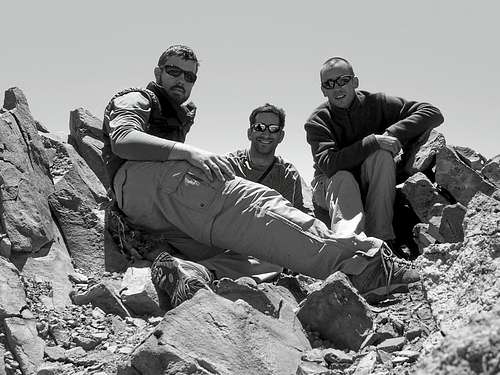
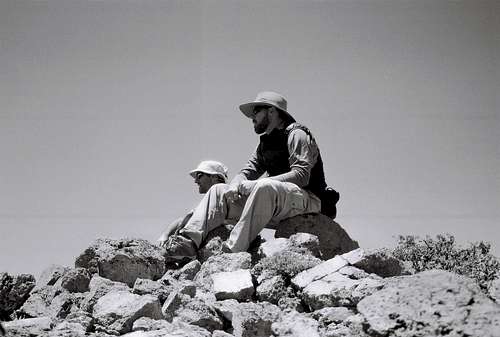
The summit of Highland Peak is a small circle about ten feet in diameter with a small rock wall that surrounded it and it came in handy because it was really windy on top. Other than the wind it was a really pleasant summit. The views were endless because Highland Peak is the highest in the area. We were able to see Silver Peak and as far north as the Crystal Range in Desolation Wilderness and Mount Rose near Reno. To the east we could see far into Nevada. And in the south we could see all the way to Yosemite. The summit was devoid of three pests that inhabit a lot of Sierra summits in the summer time, those pests being marmots, squirrels and people.
![Summit Pose]() Three Knuckleheads
Three Knuckleheads
Even though we didn’t see another soul during the climb, we did find out that Highland Peak is a pretty popular climb while checking out the register. We found entries from as far back as 1996. Peter even found R.J. Secor’s name. You know the guy that wrote the
High Sierra bible . After we had been up there for a while I checked my phone to see what time it was and to our shock it was 12:05. We then decided that it was too late to try for Silver Peak. Oh well, we got our main goal and we can always hit the summit of S-10 Peak on the way back.
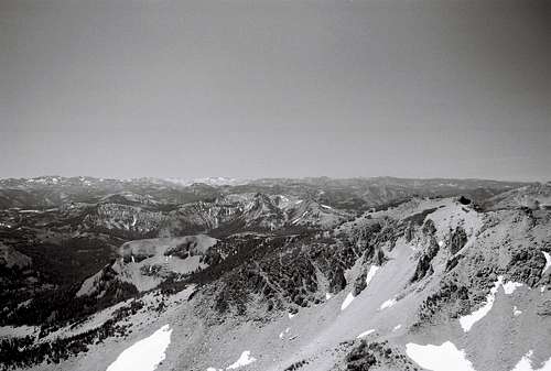
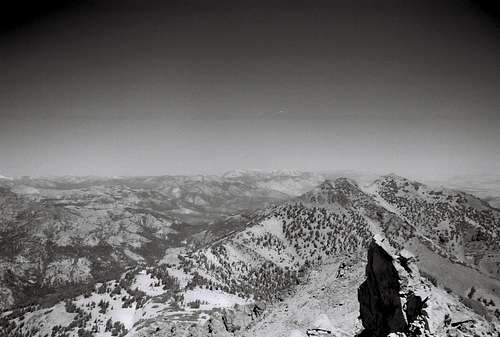
![Looking South]() Looking South.
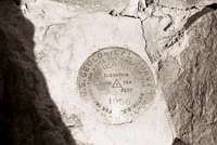
Looking South.![Highland Peak]() The Benchmark.
The Benchmark.![PJ and Peter]() PJ And Peter.
PJ And Peter.![View from the top]() Looking North.
Looking North.What Comes Up, Must Come down
After spending 30 windy minutes on top, we came to the painful decision to go down. It is always hard to leave a summit and this was no exception. We had worked hard and spent a lot of time going up. And now after what had seemed like a short time, we were going down. But all good things must end. The hike down was rather un-eventful. We didn’t see the usual un-prepared people, let alone anybody headed up to talk to. It wasn’t like a day hike where you can dream about giant hamburgers and giant ice-cold beers, which would be cruel.
We walked down the “stairs” and found out way back through the “bushy-tree” maze and reclaimed our backpacks and to out relief there were no rodents inside them eating Clif bars. We then started back up the ridge to S-10 peak, this time we headed up the other side of the ridge and lo and behold we found out that is the way the trail leads but that wasn’t the fun way, so we climbed on rocks when we didn’t need to.
When we got back to the saddle right below S-10 Peak, we dropped our packs again and headed to the summit of S-10 Peak. There are several false summits for S-10 Peak so it took us a little while to find the real one. And the real one wasn’t all that magnificent. There is no benchmark or register. But the view south was better than the one from Highland Peak. This was due to the fact that there wasn’t any mountain that can match its height until Sonora Peak, which is miles away .We didn’t spend too much time on top of S-10 Peak because it was starting to get late.
![PJ and Peter]() PJ And Peter On S-10 Peak.
PJ And Peter On S-10 Peak.
The hike down seemed to go by quick. When there was sand, we made really good time because we were able to run down. Before we knew it we were back at the first saddle and we followed the trail to the bottom of the saddle and headed of the saddle where we should have come up at if we had stayed on the trail on the way up. Oh well hindsight is 20-20. We followed the trail down off the saddle through the forest until we reached the bottom and guess what. We lost the trail. But we knew where we were going so we didn’t stress it. We quickly found the little lake and the campsite on its north shore. Since we were so close to our campsite and this one was unoccupied we “borrowed” the firewood. I really hope no one camped there that evening.
Back In Camp At 2:30. Now What The Heck Do We Do?
As we headed down off the bluff with loads of firewood in our arms we noticed the strange sounds of people. Since we had not seen or heard other people all day this was a shocking development for us. But since we were on the PCT and in close proximity to a major trans Sierra highway we were bound to run into other people. I wonder how we must have looked hiking down off the bluff with our arms full of firewood.
![Tryon Peak]() Tryon Peak From The Bluff Overlooking Noble Lake.
Tryon Peak From The Bluff Overlooking Noble Lake.
Firewood in hand we disappeared into the trees that concealed our campsite. Within seconds firewood and backpacks hit the ground and we let of a collective “woo”. I took off my boots and put on my Teva’s and had a Clif bar before heading down to Noble Lake to wash up. After washing my face and filling my Nalgene bottle I headed up to camp for a short nap. But sleep never came, so I started making notes for what would become this trip report. I had the camp to myself for almost ten minutes and the silence was really nice and it allowed me to put my thoughts to paper. But that damn PJ had to come back and ruin quit time.
After a while Peter came back up from doing a little laundry and the three of us rolled out the sleep pads and sleeping bags and started playing cards. We started out playing 31 but after a while that game got pretty boring. So we soon switched to Rummy. This turned out to be an epic game between PJ and I. Peter being new to this game didn’t fare so well, but he kept us entertained with his chorus of “F-You guys”, “This game sucks”, and “I’ll never play this game again”.
During the three-hour course of this game we watched an almost endless parade of PCT through hikers. Most of them were hiking south to north and started in Mexico midway through April. They all seemed ready for conversation and were happy to get any news from the outside world that they could get. I was surprised that all of them had heard of the Angora Fire. It is truly amazing how news spreads in the back country.
We also came to the realization that liquor would have been a welcome addition to the card game. But the coffee and tea that we had were better than nothing. The card game was a ton of fun and it was a great way to unwind after the day’s hike.
But all good things must come to an end. And finally at 6:30 we put the cards away and started to get dinner going.
The Second Night
Once again Peter and I headed down to Noble Lake to get water while PJ got the fire pit ready. I have gone camping with PJ countless times and it would seem weird to me to have anyone else start and maintain the fire. I give him a hard time about being a control freak but he does a great job at maintaining a good strong fire with out using all the wood at once. By the time Peter and I got back up to camp PJ had the fire going and we all went about doing chores.
By 7:00 our gourmet dinner of Mountain House Chicken Stew was ready to eat. It tasted like all Mountain House foods, salt. But a little Tabasco sauce helped out and I quickly destroyed my ration of salt stew. We sat around the fire for while trading stories and reminding Peter that he had a long way to go with Rummy. Soon after the sun set it was time for dessert and Chef PJ broke out the
Mary Janes Farm Mary Janes Brownies
Not long after 9:00 the wind shifted and started howling through our camp. We were pretty tired and took this as a sign to put the fire out and call it a night. So we packed up all of our food and other bear attractors and bullshitted for a couple of minutes. Sleep came quickly that night. I was pretty tired from the climb and from kicking Peter’s butt in Rummy and I didn’t have the excitement of an up coming climb keeping me up. As tired as I was I still awoke when the moon came over camp again. But I didn’t stay up to enjoy it this time, I was tired and I needed the energy for the hike out and the beer tomorrow.
How A Climbing Trip Turns Into A Beer Run.
Just as soon I fell asleep I heard voices. I crawled out of my cocoon and was blinded by the sunlight. To everyone’s surprise I was the last one up. Luckily we had nowhere to be anytime soon so I didn’t feel bad about a non-alpine start. The only things we had planed for the day were to hike out, stop for a burger and a brew on the way to Sacramento, and get Peter to the airport by 7:30 pm. Not a huge day by any means.
![Peak 10,824]() S-10 Peak From Camp.
S-10 Peak From Camp.
So we took our time making breakfast and breaking up camp. We cleaned up all the trash, most of it not ours. PJ even went about sorting and stacking the left over firewood. We were pretty much ready to hike out by 8:00 am. There was one problem, if we wanted to get to Arnold at noon for lunch we had to wait an hour or hang out at the trailhead for an hour. We chose to wait at the campsite for an hour and shoot the shit and play some cards.
By quarter to nine, we couldn’t take it anymore and we started hiking out. Our first stop was to fill up our Nalgene bottles down at Noble Lake. With our bottles full we were finally on our way out. Now for some reason the hike out was a lot more climbing than I thought it would be. The hike in was easy so I just assumed the hike out would be a piece of cake. I was just a little bit off. Even with this little surprise, we made really good time. Along the way we ran into a lot of day hikers. Most of them seemed un-prepared wearing blue jeans and not carrying water. You know the type that hike for a quarter mile and always ask “how much farther until the water fall”.
![PJ and Peter]() PJ And Peter During The Hike Out
PJ And Peter During The Hike Out![Highland Peak and Peak 10,824]() Our Last View Of Highland Peak.
Our Last View Of Highland Peak.
After an hour and a half of hiking we were back at the trailhead and to our relief Yogi and Booboo hadn’t broken into the car to. I guess Ranger Smith was patrolling in the area. With Sierra Nevada Pale Ales beckoning us we quickly packed up the car and hit the road. Our first stop was a little resort area just west of Pacific Grade called Lake Alpine. It is a pretty little lake full of tour-ons and if I had to guess it was base camp for the day hikers we ran into on the way out earlier in the morning.
Our next stop was in the little town of Arnold just west of the Calaveras Big Trees State Park. Our mission in Arnold was to have the required post climb Burger and Beer. We stopped at the first burger joint we saw. They served burgers but no beer, so we got the hell out of there. We went a couple of blocks further and found some bar and grill. We checked it out and sure enough they served burgers and beer. The hostess found us a table outside and asked us if we wanted something to drink. Without hesitation we all ordered Sierra Nevada Pale Ale. We talked as we waited for our brews and after five minutes she came back and gave us some bad news. There was no Sierra Nevada P. A. So we had to settle for Pyramid Hefewiezen.
We hit the road again shortly after lunch with full stomachs. We drove a few blocks further and I noticed a golf course. And right next that golf course we saw
The Snowshoe Brewing Company . It was too late for lunch but it was not too late to pick up some brew for the barbecue we were planning for dinner that night. Without hesitation PJ turned the car around and parked the car. Five minutes later we were back on the road with two cases of what we hoped would be some really good beer.
As we left Arnold, the mountains gave way to foothills. We all started to get into that leaving the mountains funk. It is always weird going back to the Central Valley and this was no exception. By 4:00 we were back in Sacramento. PJ and Peter dropped me off at home so I could take a quick shower and drive over to PJ’s place with Milinda and Abbie. When I got over to PJ’s he already had the BBQ going. And dinner was just about ready to be put on. The beer we picked up in Arnold turned out to be really good so now I have another reason to go back up there.
It’s really amazing how time flies when your having fun. Before we knew it, it was 7:00 and we had to get Peter to the airport. So the trip ended as it began with Milinda, Abbie, Peter and I at the airport. But as they say, “all good things must come to an end”
Conclusion
I learned a lot that weekend. Highland Peak was my first real scramble and to this day it is the highest mountain that I have summited. We have tentative plans to climb Mount Shasta next spring. But I think we will try for a late April trip instead of late June. All in all it was a great weekend in the mountains with great friends.
And for your further reading enjoyment here is
Peter's take on the weekend.


Comments
Post a Comment