
-
 5717 Hits
-
 81.18% Score
-
 13 Votes
|
|
Mountain/Rock |
|---|---|
|
|
46.70061°N / 12.41442°E |
|
|
Hiking, Skiing |
|
|
Summer, Fall, Winter |
|
|
8366 ft / 2550 m |
|
|
Overview
 Hornischegg / Monte Arnese from the west Hornischegg / Monte Arnese from the west |
The main ridge of the Carnic Alps starts in the west above the intersection between Pustertal / Val Pusteria, Tiroler Gailtal and Sextener Tal / Valle di Sesto. Though the summits are not overly impressive or even heal high, they stand out about 1400m - 1500m above the valley floors. Here the Karnischer Höhenweg / Traversata Carnica starts with its easy first stage, only to end 8 days later and 140km to the east. Thanks to a chair lift from Vierschach / Vesciaco and a cable-car from Sexten / Sesto as well as a mountain road from Sillian the area is extremely popular and can be very crowded on a fine summer day.
However - apart from the trekkers - the crowds usually stop at Sillianer Hütte, a mountain hut which is the starting point of the trekking trail. Some hikers head for Hochgruben / Tova Alto right above the hut but the mountains to the east only attract people who mean business. The first of these is Hornischegg / Monte Arnese a grass covered summit, which at closer inspection turns out to be surprisingly rocky, consisting of the omnipresent gneiss of the area. As you hike from Sillianer Hütte towards the summit you pass several leftovers from a war fought here almost 100 years ago. The whole Carnic Main Ridge was heavily contested during WW I and especially in its easily accessible western part severe fighting occurred. The strategically important location above the three valleys explains why. Thus, even today, the area is crossed by numerous trenches and in some places you will still find pieces of barbed wire lying around.
This is directly evident on the summit of Hornischegg / Monte Arnese. Here you have a mountain which overlooks big parts of the ridge and which is not readily accessible except for one side. North and south face are steep, the west ridge is rocky (consisting of big boulders) and only the east ridge allows easy access. In consequence, to the east of the summit a number of artillery positions were installed by the Italian Alpini, protecting the whole area.
 |  | 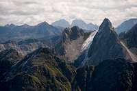 |
Today, hikers make use of the WW I installations. The regular summit trail follows a ramp, built during the war by the Italians. Positions and trenches are used to rest and many a lunch has been eaten here. Summit views are exceptional with the Sexten / Sesto Dolomites on full display in the east and the Hohe Tauern Group stretching across the north. The remainder of the panorama is taken by the Carnic Alps themselves. Hornischegg / Monte Arnese is the last easy summit of the Karnischer Höhenweg / Traversata Carnica trekking trail, which gets stunningly beautiful beyond. A mountain definitelyy worth a visit!
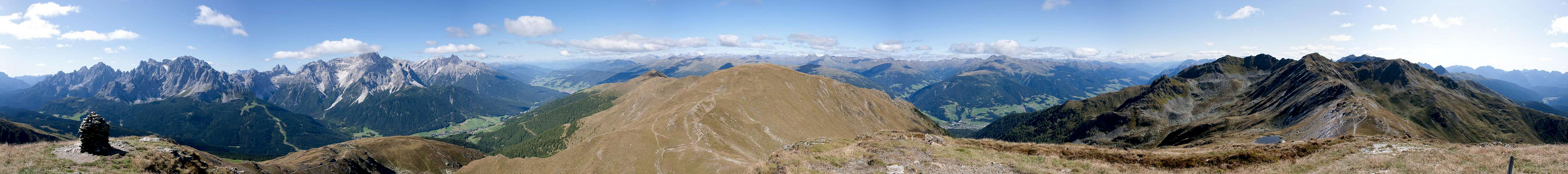
360° Summit Panorama
  |
Getting There
 On Karnischer Hoehenweg / Traversata Carnica between Hornischegg and Holbrucker Spitze
Hornischegg / Monte Arnese is one of the first summits on the Karnischer Hoehenweg / Traversata Carnica trekking trail which officially starts at Sillianer Hütte to the west of the mountain. It can be reached from three sides, from Sillian in the north, from Vierschach / Vesciaco in the north-west or Sexten / Sesto in the west. While you can hike to hut and mountain, the average elevation gain is already 1200m (1600m), which is why most trekkers take advantage of the following technical help:
- From Sillian you can take a taxi to Leckfeldsattel, a saddle between Hochgruben / Tova Alto and Füllhorn / Corno Copia. From there only 200m remain to reach the hut.
- From Vierschach / Vesciaco a chair lift takes you to the west ridge of Helm / Monte Elmo. Getting to the hut requires climbing the mountain, or using the hut support road to its west.
- From Sexten / Sesto a cable-car runs to the west slopes of Helm / Monte Elmo. It is separated from the chair lift by less than one kilometre so that the same itineraries lead to Sillianer Hütte.
There is also a hiking route which directly connects Sexten / Sesto with the mountain, which, however is mainly used for descent due to the huge elevation gain 7 loss.
Red Tape
There is no red tape here. No parking fees, no permits. You are on the Austrian - Italian border, however, and even in a unified Europe you should be aware of this. Keep your ID at hand.Accommodation
The closest hut is Sillianer Hütte, about 1h west of the mountainWeather Conditions
Maps & Books
Books
- Osttirol Süd
W. Mair
Rother Verlag
ISBN: 3-7633-4132-3
- Dolomiten 5 - Sexten - Toblach - Prags
F. Hauleitner
Rother Verlag
ISBN: 3 7633 4199 4
- Dolomiten
P. Fleischmann
Kompass Verlag
ISBN: 3 8705 1409 4
Maps
The most commonly used maps are the ones by Kompass and by Tabacco. The Kompass one is good as an overview map while the Tabacco one offers more details.
- Sextener Dolommiten / Dolomiti di Sesto
Kompass Map WK 58
ISBN: 3-87051-065-X
Scale: 1:50000
- Dolomiti di Sesto / Sextener Dolomiten / Hochpustertal / Alta Pusteria
Tabacco Map 010
Scale: 1:25000