![Buffalo Hump as seen from the...]() Nearing Orogrande Summit
Nearing Orogrande Summit![Headwall road returning from...]() Typical road condition
Typical road condition![Hump Lake is the starting...]() Hump Lake
Hump Lake![The east side of Buffalo Hump...]() Approaching from the east
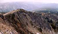
Approaching from the east![The ridgeline north of the...]() Summit Ridge
Summit Ridge![The ridge running south of...]() South ridge
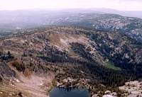
South ridge![The north slope of Buffalo...]() North ridge/Crystal Lake
North ridge/Crystal Lake![Looking west from the summit...]() View west over Mirror Lake
View west over Mirror Lake
The most difficult and adventurous thing about a trip to Buffalo Hump is the road in. From Orogrande to the pass was rough. The road from the pass down into Lake Creek was much worse and had me concerned. From Lake Creek on up to Hump Lake was absolutely insane. Its just a washed out boulder field with water running down it in many places. I’m certain we traveled more vertically than horizontally as we bounced along smacking our heads on the roof and smashing the oil pan on the rocks. I wasn’t sure the pickup would make it back out as it began to die frequently on the bigger hops and the engine light stayed on steady. We ended up parking it at the road up to Crackerjack Mine and walking the rest of the way up the switchbacks to ascend the headwall up to Hump Lake. It was a good thing because the road unbelievably got much worse. The grade was steep; boulders rose abruptly two feet high and there were numerous ledges just as high. We talked to a man on a four-wheeler who used to take his truck in. He would put it in low gear then walk outside it while reaching through the open door to steer it. But the road was worse these days and he no longer wanted to try it.
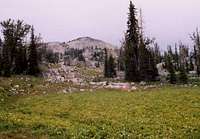
This added about 1.5 miles to our hike, which wasn’t too bad. The hike up was nice with good views of the upper Lake Creek basin and the North Pole. There were several open, moist rocky slopes backing up to the steep headwall that were full of great wildflower gardens. Common plants were Menziesia, Spiraea densiflora, Mimulus lewisii, Parnasses, Saxifraga arguta, Lonicera utahensis, Ledum, Vaccinium globulare, Ligusticum canbyi, Xerophyllum tenax, Senecio triangularis, Castilleja rhexifolia, Pedicularis racemosa, Luzula hitchcockii, Deschampsia atropurpurea, Juncus mertensiana, Castilleja miniata, Arnica longifolia, and Carex luzulina. Some other noteworthy species were Potentilla fruticosa, Saussurea americana, and Delphinium occidentale.
Arriving at the lake, I was stupefied to see a couple trucks and SUVs parked there. Some people have no care for their vehicles. The lake itself was quite beautiful. It sits about 7,800 feet, and is not far below the timberline. The surrounding forest is open Engelmann spruce, subalpine fir and whitebark pine. Many snags of the latter are present. The low ground near the lake and in other small meadows nearby are dominated by Caltha biflora, Carex luzulina, Carex scopulorum, Pedicularis groenlandica, Senecio triangularis, Aster sp. and assorted species of fescue and poa. Between Buffalo Hump and the lake the terrain is rolling with several small flat wetlands and brooks between mounds of granite. Some higher elevation species start to show up, but a surprising number of lower species are found this high. Castilleja miniata is common, but the typically higher C. rhexifolia was not found. Carex nigricans, Poa epilis, Poa gracillima, Luzula hitchcockii, Veronica cusickii, Vaccinium scoparium, Aster foliaceus, Antennaria lanata, Fescues, Juncus drumondii, Juncus mertansiana, Hypericum formosum, Polygonum phytolaccafolium, Phlox sp., Phyllodoce empetriformis and others are abundant.
Above this rolling terrain, the east slope of the mountain is mostly rock with a small strip of more developed soil extending from the base of the final rise on up to the crest just south of the summit. Very stunted and sometimes matted subalpine fir and whitebark pine are scattered about. The vegetation drops dramatically with occasional Vaccinium scoparium, Luzula hitchcockii, fescues, Silene douglasii, Phyllodoce, Cryptogramma crispa, Juncus drummondi, Phlox, Eriogonum, Juniperus communis, Campanula parryi, Lomatium sp. and others present. On top it finally got closer to alpine conditions with Luzula spicata, Ivesia gordonii, Smelowskia calycina, Potentilla nivalis, Saxifraga bronchialis, and Carex phaeocephala. There is no true alpine in north-central Idaho, but the summit cap of this mountain gets pretty close. The flora was pretty shot this late in the year and I will need to be revisited in late July to know what really is all here.
The trip was hard on Janet. First she had to get up hours earlier than she normally does. Then she was stressed out over the difficulty of the road. I was too. She wasn’t feeling well and the walk up was hard on her. She was very slow moving and I almost abandoned the hike several times. In the rolling gardens between the lake and the summit I all but quit when dark clouds rolled in and the rumbling started, but decided to go a little further and see how it shaped up. Soon we were almost to the final short push to the top. She kept telling me to go ahead since I was close. I did, but took my time to look at the plants and views and never got more than 40 or 50 feet in front of her. She was a real trooper.
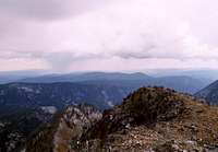
Finally we made the ridgeline and took in the view to the west. Small trees come up the western face to the ridge top. This is a stark contrast to the rocky bare east side. Perhaps the west side racks just a bit more moisture out of the oncoming clouds. Below was Mirror Lake. A trail passes south of Buffalo Hump to this lake and it looks like a nice hike. Further west were the Gospels on the near horizon. Much further to the southwest the Seven Devils and even the Wallowas of Oregon were just visible. The west side of Buffalo Hump is much steeper with many cliffs and near vertical slopes. In the distance in many directions we could see several small wisps of smoke from lightning strike left over from recent storms. With the moist forecast and lack of fuels at these elevations, none would amount to much.
On the top of Buffalo Hump there is a guest book register and Janet signed us in. We spent only a few minutes there to take pictures, look at the flora and walk over to the north facing cliffs to peer over at the Wiseboy Lakes. We had the rest of our lunch and then hiked back down. We were both very tired with sore feet and Janet visibly didn’t feel good. I felt bad for pushing on to the top since she was having a hard time. We finally made it back to the pickup just as the real rain hit. The storm cells bounced all around us for the previous three hours, some with heavy rain and rumbling, but we had not been hit. The drive out was slow and cautious, but went OK. I just put it in 4 low and crept in first or second gear over the jumbled boulder surface. We went into Elk City to get some sodas and snacks to refresh us and then drove home as dusk came on. A full day and we were really beat.


Comments
Post a Comment