
|
|
Mountain/Rock |
|---|---|
|
|
39.75146°N / 119.78926°W |
|
|
Washoe |
|
|
Hiking |
|
|
Spring, Fall, Winter |
|
|
5947 ft / 1813 m |
|
|
Overview
Hungry Mountain is a rocky-topped summit about 15 miles north of Reno, Nevada. At 5,947’ it certainly doesn’t tower above the landscape, but it holds its own charm. This is because it is located in a brush-covered desert landscape, with wide open views of desert vistas. Hungry Mountain is not located in pure desert, like in other parts of Nevada. This area sees more rain and snow than the true desert further east, especially given its close proximity to the northern Sierra Nevada mountains. However, it is quite desert-like, and is fun outing in winter, late fall, or early spring.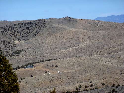
Hungry Mountain from the south
Hungry Mountain stretches for about 2 miles north-south and 2 ½ miles east-west, cresting in the middle like a pyramid. It has a rocky-topped summit that requires some light scrambling to reach the actual summit.
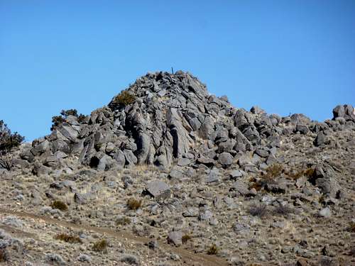
Rocky summit
Access can be an issue via the shortest routes. It is better to find a parking spot on federal lands, leaving no doubt that you will not be in trouble with the locals. Thus, the best option is to hike one of the longer (>4 miles one way) routes to the summit.
Once at the summit, there are plenty of great views with some views to the Sierra Nevada to the southwest and numerous desert peaks in all other directions. A small section of Pyramid Lake is visible from the summit.
The best time to hike here is probably in early winter, when it is still dry and often snow free. Spring is possible, but beware of muddy conditions. Late fall is possible, but only if it isn’t too warm. 45-55 degrees is ideal conditions here. Beware of windy days.
Getting There
Although roads go right up towards Hungry Mountain, these are mostly on private lands. It is possible to legally reach Hungry Mountain this way, but not recommended. For informational purposes, these roads are Argonaught Way on the south side (less than 1 mile from the summit) and Bronze Hill on the north side (less than 1 1/2 miles from the summit).For this page, I will describe two primary routes to Hungry Mountain that start on federal lands.
The first is to head towards the Hungry Ridge which is a totally different mountain ridge situated about 4 miles east of Hungry Mountain. The Hungry Ridge is on the east. Hungry Mountain is across the valley to the west. But this is a great way to hike directly across federal lands.
From Reno take I-80 east to Pyramid Highway (445). Take 445 north for about 7.7 miles and turn left at the stoplight for Eagle Canyon Road. Follow the signs around traffic circles to stay on Eagle Canyon Road. Eventually you will pass Spanish Springs High School. Stay on the road and continue past the sign for the Reno/Sparks Indian Colony about 5 miles further up the road. This is tribal lands, but not restricted to through traffic.
After driving past the colony (basically a bunch of homes), the Eagle Canyon road turns west back into the residential area. Continue into the playa, driving another ½ mile past the residential area. A good place to park is on a side road on federal land at 39.708546, -119.754911. This is at 4955’.
The second is to head to Lemmon Valley, where you can actually grab a higher summit, Peak 6021, before hitting Hungry Mountain. This can be accomplished in 9 miles round trip.
From Reno, drive north on Highway 395 to Exit 74. Drive north on Lemmon Valley Road for about 4 miles and continue as the road turns northwest towards to a residential area. Once near the residential area, take a right on Waterash, then a right on Tupelo, and a left on Matterhorn Blvd (aka CO HWY 165).
This is also the road to take to get to Argonaught or Bronze Hill.
If going the 9 mile round trip route (south side of Hungry Mountain), follow Matterhorn Blvd out of town, and then continue for a little under a mile. The best place to park is at the Silver Arrow Ranch Regional Archery Facility. It is Washoe County Open Space land, although maps I have found show it to be on federal land. Drive up the very well graded dirt road for 1/3rd of a mile and park 100’ up at the parking area for the archery course at about 5385’.
Route Information
East sideFor the east side route, head straight east for about 1 ¼ miles from the parking area until you reach an intersection. Take a right and follow this road for almost 2 miles as it heads towards the southeast side of Hungry Mountain. Once at the base of Hungry Mountain take a quick right on a road that leads to a parallel road heading up the slope. The summit is a little over a mile away and 650’ up.
The total round trip hiking distance for this route is about 8 ½ miles with an elevation gain of about 1030’.
South side
The south side route from the archery range parking area is about the same distance (if not heading to Peak 6021 on the way). From the parking area, walk over a small set of stairs over a fence. Walk carefully through the course, heading mostly on main roads heading up the slope and northbound towards the rocky-topped Peak 6021. Find your way to the main road heading up the slope. Ultimately you will have to cross over a fence on a main road heading as you head up the slope. The land past this fence is supposedly on federal lands, and indeed there are no signs indicating it is private lands. After a little over a mile from the parking area, the road descends to the east. A road heads straight towards Hungry Mountain. After 1 ½ miles of mostly descent you reach an intersection with another road and take a left towards Hungry Mountain. You will soon cross Argonaught Way. There is a house on the right and a No Trespassing Sign. Stay to the left of the sign and you are fine. Head directly up the slope and towards a false summit. There is a use trail on the ridge leading towards the false summit. Once you pass the false summit, Hungry Mountain comes into view.
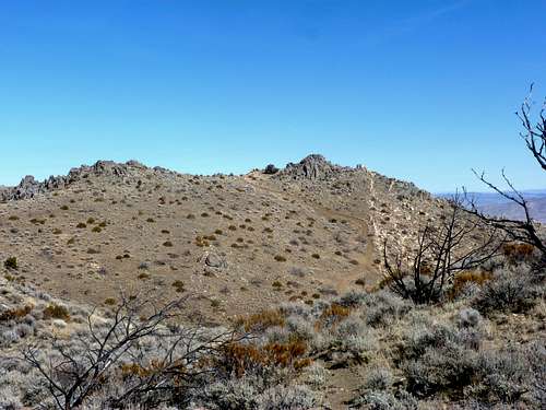
First view of the summit from the south side route
It is just a quarter mile away, and requires descending over 100’ and then back up over 130’. This is on the boundary of private land and federal land. Again, there are no signs indicating the area is off limits to hiking. But there is a fence you have to get over that can rip clothes. This isn’t a significant obstacle.
The total distance via this route is about 8 ½ miles with an elevation gain of 1200’ one way. If you summit Peak 6021 on the way (recommended) you add ~140’ and ½ mile.