
|
|
Route |
|---|---|
|
|
47.56520°N / 121.1798°W |
|
|
Snow & Glacier |
|
|
Most of a day |
|
|
Alpine II |
|
|
Approach
From the Cathedral Rock Trailhead 1345 - 3350 ft - start hiking. Make sure your pack weighs at least 30 kilograms. If you're light, it's OK. Just add rocks at the river crossing (bridge). Reach Squaw Lake at 2.5 miles from the Car park. Keep going up the.very well-kept trail (jog if you're feeling fit), and hit Cathedral Pass at 5500 ft and 4.3 miles or so from the trailhead. Very pretty. Go over the top of the pass and start down the other side on the PCT for maybe 0.5 miles or so until you find an obvious switchback with the main trail running down and LEFT towards Deep Lake and a small tred running straight and sort of RIGHT, hugging Cathedral Peak. This trail may or MAY NOT be marked. It is the Peggy Pond Trail 1375. This is the one you want. Take it, man. This trail passes Cathedral Rock on its West side and arrives in a little hollow (two main basins) between Cathedral Peak and Mt Daniel at about 5560 ft. The 1375 trail is about a mile long but very rough as far as hiking trails go. As an approach trail, it's like a superhighway! :-) The total time from trailhead to Peggy's Pond is 3-5 hours depending on potty breaks, number of river rocks in your pack, and who got stuck carrying the beer (if you're Canadian).
[Most of this information was excerpted from Potterfield and Nelson, Vol 1, with small additions from my own memory.]
 |  |  |
Route Description
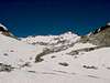
The direct route up the Hyas Glacier Headwall goes straight up the gut of Hyas Creek basin on whatever convenient game and approach trails are available at zero-dark-thirty. Most of the polished slab steps are turned by scrambling on the right side. Once up on the glacial remnants, make as direct a line as possible for the very visible East Peak, which is just to the left of the VERY visible East Spire. Connecting the snow from the lower and upper glacier remnants is the crux of the climb, and about 50 feet of 3rd class scrambling (in crampons) was required on this August 22 climb in a mild snow year.
Once on the steep 30-35 degree upper slope, keep heading for the East Summit - usually up and to the right. Once below that summit, turn the tower on the left (West) side and walk above the Venus and Spade Lake drainages (incredibly beautiful!) - this is usually loose so take care - and on towards the Middle Summit. Ascend the snow slopes of the Middle Summit and then down the other side and back up to the West Summit! FINALLY! You made it. (whew)
On the descent, you can return the way you came - although i would recommend descending south (around not through) of the Hyas Glacier Headwall rock bands, close to the Southeast Ridge. Heck, after traversing all the way over there from the East Summit to a point where you can clear the rock bands, you're so close to the Southeast Ridge you could just descend that as well. For the easily bored, go ahead and go the other way around the East Peak from the Middle and descend the standard Daniel Glacier route with the 35+ degree couloir running just east of the East Spire!
Also refer to "East Route" Mt Daniel in Beckey, Vol. 1, pp. 178-183.
 |
Essential Gear
The one thing nice about this route is that there is no crevasse danger that we have ever seen. But then again, maybe we don't see too well. The Daniel Glacier route (or descent) certainly has some BIG crevasses, so all the standard glacier travel gear is required, whichever route you do. The route you intend may not be the route you get into... if you know what i mean?
Harness, rope, biners, pulleys, prusiks or ascenders, crampons, ice axe. Also dont forget stuff for you main camp at Peggy's Pond, like a way to varmint-proof your foodstuffs and smellibles.
Miscellaneous Info
If you have information about this route that doesn't pertain to any of the other sections, please add it here.
DDvO - Aug 7, 2007 4:30 pm - Voted 9/10
Peggy Pond Trail 1375 not markedAs of 2007, the turnoff to Peggy Pond Trail 1375 from the Deep Lake Trail is not marked.
eharman - Sep 10, 2013 1:13 pm - Hasn't voted
Trail now markedAs of 9/2013 the Peggy's Pond Trail is marked. The main trail makes a switchback to the left and if you go straight instead of making the turn you're on the Peggy's Pond Trail. The sign is a little bit down the trail (10'?) and on the left.