
|
|
Route |
|---|---|
|
|
44.10610°N / 113.7777°W |
|
|
Mountaineering |
|
|
Spring, Summer |
|
|
One to two days |
|
|
Class 3 |
|
|
Moderate |
|
|
Overview
 The Good Click to enlarge
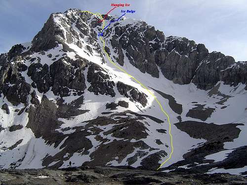
Idaho Peak North face is located at the head of the Merriam lake basin on the N.E side of the Lost River Range in Idaho.
Duane Monte is credited with the first ascent of the route in the early 1990's. This is an exciting route on Idaho's seventh highest peak and a challenge for those wanting more than the standard fare. It’s difficult to give the route a rating due to the ever changing snow conditions during the climbing season. Early in the year or late in the day, avalanche danger can run from stable to “what am I doing here”? In late summer conditions it can run from very little snow to dense alpine ice, but the route is usally a straight forward climb up an obvious conduit of snow.
Getting There
 Pahsimeroi Valley TOPO.
 Idaho Peak N.F. Topo. Click to enlarge.
Stop In Mackay or Challis and pick up a free Forest Service travel Map at the USFS. office or any convenience store.
From U.S. Hwy 93, 46 miles north of Arco (32 miles south
of Challis), follow FS Road 116 northeast over Double springs
Pass for 10 miles to the turnoff of FS Road 117. Look for the Horse Haven Pass sign. Follow 11 7 over Horse heaven Pass for 6 miles to the junction with FS Road 118. Follow 118 up the West Fork Pahsimeroi River for
4.5 miles to its junction with FS Road 267. Follow 267 for 2.5
miles up the West Fork Pahsimeroi River to the end of the
road. The FS Trail to Merriam Lake begins near the end of the
road. Climb for about 2.2 miles to Merriam Lake. From the lake continue sout/west to the 9,800' contour, angle right and climb into the central cirque where you will have an unobstructed view of the north face.
Route Description
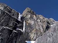 This shot was taken shortly after a large section of the hanging ice shelf collapsed onto the route. The coulior is no place to be when things start to heat up!
 In a narrow part of the Coulior below the Ice bulge.
During the spring and early summer, it’s advisable to get an early start on the route. The upper face has the potential of shedding a large amount of Ice rock as the day warms up. Don’t forget your helmet!
The First half of the face consists of wide open snow slopes leading to several different possibilities. The obvious route follows a 45% couloir up the center of the face. Follow the couloir to the 11,600’ contour. At that point you’ll be looking at a large cliff band with a shelf of hanging ice. The water and ice chunks that fall from the shelf form an ice bulge that covers the exit from the couloir. Climb over the Ice and angel right toward a more open snow face. From there, climb to the obvious notch on the summit ridge.
Depending on conditions, one may decide to descend the north ridge to avoid rock fall on the north face. The ridge is class three but route finding vigilance is necessary to avoid class four terrain.
Essential Gear
Helmet, Ice axe and Crampons top the essential gear list. A short length of rope lends a great deal of security while climbing over the ice bulge and may come in handy on the descent as well.Camping
 Camp below the lake
Although the north face of Mount Idaho can be climbed in one very long day with travel, it would be a shame to miss the opportunity to camp at Merriam lake. The lake is surrounded on three sides by steep peaks over 11,000’ and you’ll have an awesome view of Mt. Idaho’s east face. As soon as the lake starts to melt (middle to late June) those with the foresight to bring a little luck and a fishing pole can catch Brook trout. Don’t forget to bring a footprint for your tent, some of the tent spots on the lake can be a little damp.
Photos
several of these photos (all the good ones) were taken by Super Dave.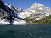
Links
Dave's Hiking PageSuper Dave
Lost River Ranger District