A picture (or two) are worth a thousand missteps
The purpose of this short report is simply to present updated pictures of key points along the Pelican Canyon route to the summit of Fishlake Hightop. I hiked this trail on August 27, 2009.
At the northwest end of Fishlake you will see the following sign. Turn left and take the less-than-friendly ruts posing as a road up to Pelican Overlook.
![Fishlake Hightop]() Turn left here - you are at the northwest end of Fishlake.
Turn left here - you are at the northwest end of Fishlake.
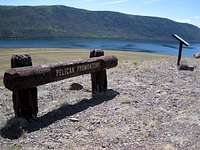
At Pelican Overlook enjoy the view of Fishlake. This point is impossible to miss. On the lake side of the parking area are the following two objects.
![Fishlake Hightop]() Pelican overlook or promontory.
Pelican overlook or promontory.![Fishlake Hightop]() Historical trivia at the promontory. Learn while viewing.
Historical trivia at the promontory. Learn while viewing.
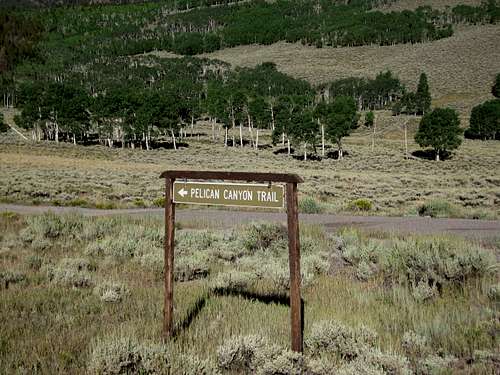
On the west edge of the parking area you see the next sign and look up at the forested and wide Pelican Canyon. Sagebrush dominates the foreground while aspens and evergreens fill the canyon.
![Fishlake Hightop]() At last, the trailhead. You are going to Tasha Springs & Fishlake Hightop!
At last, the trailhead. You are going to Tasha Springs & Fishlake Hightop!
After 100-150 yards you see this sign. Take the left trail.
![Fishlake Hightop]() Take the left fork. I know for a certainty that going right does not work.
Take the left fork. I know for a certainty that going right does not work.
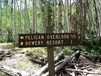
One half mile along the pleasant walk through mostly aspens this sign is on your left. Continue westward.
![Fishlake Hightop]() At least you know about how far you have walked. Keep going into the canyon & enjoy the aspens.
At least you know about how far you have walked. Keep going into the canyon & enjoy the aspens.
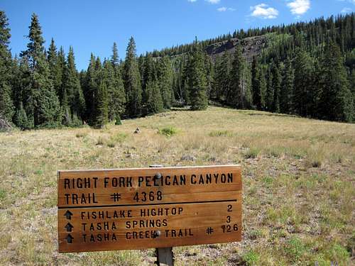
At about the 2-mile point these two signs have been set solidly. A small meadow is to the northwest, and after proceeding to the right and as you are standing next to a cairn, you can glance 90 degrees to your left and see a small pond surrounded by lush vegetation.
![Fishlake Hightop]() The sign on the left at the 2-mile point. Don't go left.
The sign on the left at the 2-mile point. Don't go left.![Fishlake Hightop]() The sign on the right. Meadow behind. Cairn visible. Take this way.
The sign on the right. Meadow behind. Cairn visible. Take this way.
The trail is easy to follow by either a well-worn set of tracks or by cairns. Once on the first plateau, you see this view looking northwest. As you cross the plateau heading generally for the north end of the long rocky rise, occasional cairns will help point the way.
![Fishlake Hightop]() On the first plateau with .5 miles to go. The summit is directly ahead at the northeast end of the outcropping of big, big boulders you can see in the distance.
On the first plateau with .5 miles to go. The summit is directly ahead at the northeast end of the outcropping of big, big boulders you can see in the distance.
Here are pictures of a forest service sign/message board which includes a rough map of your location and Fishlake Hightop summit.
![Fishlake Hightop]() A look at the FS map/message board with the bouldered plateau in the background.
A look at the FS map/message board with the bouldered plateau in the background.![Fishlake Hightop]() Direct view of map/message board.
Direct view of map/message board.
I climbed up the northeast end of the highest boulder outcropping and found myself reaching the summit adjacent to the biggest boys there including the actual "summit boulder."
![Fishlake Hightop]() A successful climb to a scenic county highpoint. The benchmark is near my right foot.
A successful climb to a scenic county highpoint. The benchmark is near my right foot.
I hope these pictures help the first-timer reach the summit of a very interesting county highpoint. It took me less than two hours to reach the summit from Pelican Point and less than one hour twenty minutes to get back to my waiting vehicle. I am a fairly aggressive hiker, so make appropriate adjustments to those times. It was very dry the day I accomplished this hike and the wind was not a factor.


Comments
Post a Comment