

lcarreau - Apr 9, 2008 11:06 am - Voted 10/10
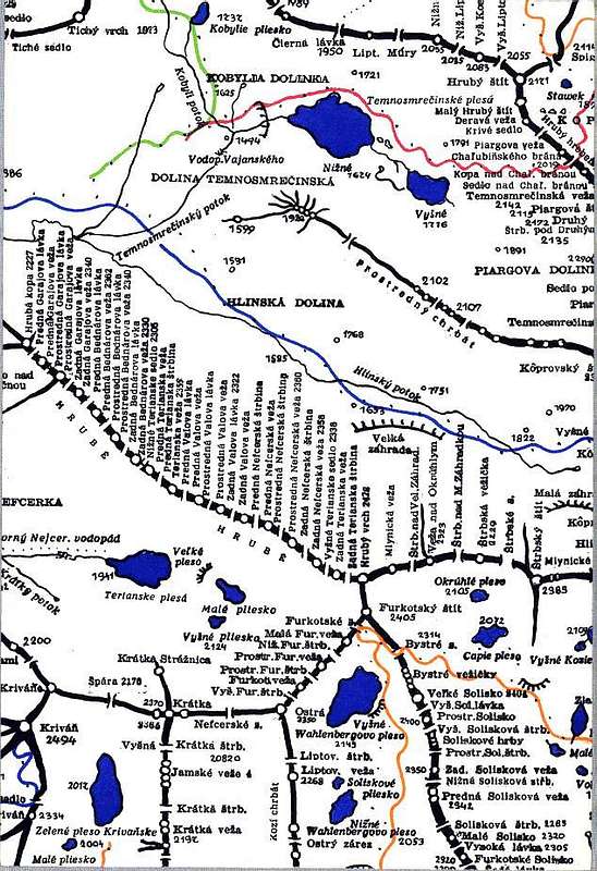
Looks like anextensive map. The trail in red passing
at the shore of the body of water is open
now??? I'm very happy that you have the
country of Poland as a neighbor. From what
I have experienced, the Polish are a very
progressive, intellegent and peaceful people.
- Larry of AZ

Tomas Kristofory - Apr 9, 2008 11:52 am - Hasn't voted
Re: Looks like anThe red trail is open now, but ends at the shore of the tarn. Polish are very pleasant neigbours as well as other people of good will. Cheers Tomas :)
lcarreau - Apr 15, 2008 9:36 pm - Voted 10/10
Re: YesGood will is GOOD to have in this world.
Of course, everybody makes mistakes. For
example, take a look at the 52-year-old
man who was traveling up to the summit rim
of Washington state's Mt. Saint Helens
(volcano) on his gas-powered snow machine.
He got off to look into the depths of the
volcano's crater, and ended up falling
1,800-feet into it! I wonder if he NOW is
more in TUNE with the phrase: "Gravity is
a harsh mistress!" Take care, Tommy!
Tomas Kristofory - Apr 16, 2008 3:42 am - Hasn't voted
Re: YesSad story.. I saw the page and photos of Mt. Saint Helens. It looks quite difficult (extreme weather conditions). Another man died last week in High Tatras on slope of Satan, when snowboarding the long, famous and dangerous Cerveny zlab chute. He was a perfect climber... And couple of weeks ago another man died on the bottom of the valley Mala Studena dolina (Between Prostredny hrot, Ladovy stit, Baranie rohy and Lomnicky stit - all have SP pages). He fall into the Obrovsky waterfall. He probably left the trail to boulder some rock and slid on wet or ice covered rock, because falling from the bridge of hiking trail is hardly possible. Look here for summer view of the bridge with the hiking trail. This is the view of the waterfall from the trail bridge. The mounain rescue officials stated, that he fell 40 meters and was dead immediately, despite being accompanied by a doctor, who took him off the water in a minute and uselessly tried to save him. Also you take care, we are never safe in mountains, Larry.

visentin - Aug 26, 2008 10:05 am - Hasn't voted
mapswhat is this map ? do you have any other samples ? :)
On my side, I found these ones :
http://www.svts.sk/kluby/odznaky/tovht/M1.jpg
http://www.svts.sk/kluby/odznaky/tovht/M2.jpg
http://www.svts.sk/kluby/odznaky/tovht/M3.jpg
http://www.svts.sk/kluby/odznaky/tovht/M4.jpg
http://www.svts.sk/kluby/odznaky/tovht/M5.jpg
Tomas Kristofory - Sep 19, 2008 4:30 am - Hasn't voted
Re: mapsHi Eric, I included the link to the page with other samples of maps of Tatras. Maps you found on the page of my climbing club include only non-marked trails to all major High Tatras summits. Those maps are from a book, a mountain guide. These maps don't include our trail, because they don't include marked trails. Cheers, Tomas :)
visentin - Sep 19, 2008 4:34 am - Hasn't voted
thankssuper !
Have you watched my links ?


Comments
Post a Comment