My acquaintance with Salim, my Jewish Iranian mountain guide, was quite accidental. We have become good friends although I am an atheist and he is a very devout Jew. After the 1979 revolution in Iran, Salim had immigrated to Israel but he missed the mountains so much that he moved back to Iran (apparently not the first Jewish Iranian to do so). Anyone who loves the mountains that much is certainly a friend of mine.
I had left Iran for the United States in 1983 when I was only 18 years old. As a teenager, I always wanted to climb the peaks of the Alborz Mountain Range but had only had the opportunity to hike up the slopes of Mt. Tochal (3964 m, 13005 ft) which rises directly above the city of Tehran. I spent the next 21 years dreaming of going to Iran to explore its magnificent mountains. The dream finally came true in 2004 when I went for an 8 day tour of Alam Kooh (4850 m, 15912 ft) and the high peaks of the Takhte Soleyman Massif. Having been away for so long, I wondered about the state of mountain climbing in Iran. I was very pleased to discover a vibrant climbing community. All of the guides that I worked with during the next few years turned out to be well trained and government licensed climbers some of whom had had experience in the Himalayas.
I met Salim in 2005. When planning the trip with my tour company they had designated a different guide who was in Nepal at that time coordinating the efforts of the first group of Iranian woman on Mt. Everest. It soon became apparent that he would not make it back to Iran in time for my trip. The tour company designated a second guide. He, however, injured his knee just a few days before my trip, so I started with a third guide. After a couple of days in the mountains, they contacted my guide via his cell phone telling him that his wife had been in a climbing accident. She was ok herself but apparently a man had fallen to his death right in front of her and she was obviously in a state of shock. That was when Salim was sent to the mountains to find us and relieve the other guide.
From the very beginning, it became obvious that Salim was very religious. Before having our first supper together, he said he had to do his prayers (At that point I was thinking that I had come across a devout Muslim. No one else that I had worked with in Iran had been religious). I saw that he rinsed his hands with water, pulled a small book that seemed to contain Hebrew writings out of his backpack, sat on the ground and began to read the book--whispering it quietly while slowly rocking his upper body back and forth. He then touched a piece of bread, whispered a few other things and was then ready for supper. I soon learned that when it was time, prayers had to be done no matter where we were: on top of a mountain, in a taxi, in a restaurant…These rituals were usually a novel curiosity to me, though sometimes tested my patience, particularly when precious time was not spent in pursuit of mountains. I often recall how upset (but at the same time humored) I became when we were on top of a mountain and he used my last bit of clean water to rinse his hands before his prayers. I should also mention that except for Tuna Fish, he only ate kosher meat (which is available at special stores in Iran but is not used in the restaurants or in preserved foods). A few days into our trip I noticed that while my previous guides had fed me delicious preserved Persian cuisine, we were having Tuna Fish for lunch and only vegetable soup for dinner every day (plus assorted breakfast and snack items). This was hardly enough calories to replenish the thousands of calories we expended each day. For the 2006 trip, he agreed to separate my food from his.
SIYALAN AND KANDIGAN PEAKS TRIP REPORT
Climbed the southern slopes of the peaks (Alamoot River Valley) and descended the northern slopes on the Caspian Sea side (Dohezar River Valley)
STATISTICS:
Trailhead: Village of Haniz (2150 m, 7000 ft)
Siyalan Simmit: 4190 m, 13747 ft (36 Km, 22 miles south of the Caspian Sea Shore)
Kandigan Summit: 4015 m, 13173 ft
End Point: Village of Asal Mahaleh (1250 m, 4100 ft)
Total Hiking Distance: 32 Km, 20 miles
We climbed Siyalan and Kandigan in a three day hiking program. Several days prior to this trip, we had done a 7 day trip to the Dokhaharan area where we had summited 8 peaks. On the last day of that trip I had twisted my ankle. Having rested for a few days in Tehran, I was hoping to be a in a good enough shape to tackle Siyalan and Kandigan Peaks.
SUNDAY JUNE 25, 2006
Got up at 1:30 a.m. in my cousin’s apartment in Tehran (elevation 1450 m, 4800 ft). I had gone to bed at 10:30 p.m. and had not fallen asleep at all. I called Salim. He said he and the driver will leave soon. Packed my last items, went outside and sat under the trees in the alley. It was 2:20 a.m. when Salim and the driver came in a Nissan Patrol. The driver was a young man who had come from a road rally in the desert the day before.
Soon we were driving on Tehran’s freeways which at that hour had little traffic. When I had left Iran in 1983, Tehran had been a city of 6 million people. The population has now swollen to 12 million. Despite a new subway system and modern freeways that crisscross the city, the daytime traffic in Tehran is almost always at a near stand-still.
We then took the freeway to Karaj, a town 40 Km west of Tehran. Urban sprawl has now connected Karaj to Tehran. West of Karaj, we continued on the freeway to the town of Ghazvin (140 Km west of Tehran). The freeway had three lanes on each side and was lit all the way to Ghazvin. You can see the lights of this road from the plane when flying from Tehran to Europe. The road travels on a plain at the southern base of the Alborz Mountains. I was getting sleepy but I wanted to stay awake to see the countryside.
Just before reaching Ghazvin (elevation approx. 1300 m, 4250 ft), we exited onto a narrow two lane road that headed north into the foothills of the Alborz Mountains. It was now around 4:00 a.m. and was beginning to light up (Iran no longer observes the day light saving hours so 4 a.m. looks like 5 a.m.)..
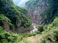
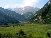
The slopes were covered with thorns and dry grass. We made many switchbacks and went up to a pass (2350 m, 7700 ft) where the Shah Rood River Valley appeared to the north. Shah Rood is a deep and wide valley in the western part of the Central Alborz Mountains. The Shah Rood River drains from the east to the west and joins the Ghezel Owzan River to create the Sefid Rood River which is the second largest river in Iran and drains into the Caspian Sea.
Traveling north of the pass, the road made one switchback after another as we descended the slopes which were now covered with yellow grass and scattered groups of trees. This looked so much like California chaparral country. I was expecting to see the sign for San Jose to pop up, after each bend. I kept thinking of the Beach Boys and David Lee Roth singing “I wish they could all be California girls”. The shadows of the higher peaks of the area were now visible to the northeast. These were probably Siyalan or Khashechal Peaks.
The switchbacks finally ended at the bottom of the valley (900 m, 3000 ft) where we crossed the Shah Rood River and reached a village known as Rajai Dasht, then headed east. The river ran on the southern end of the valley, which was roughly 10 Km (6.5 miles) wide. Rather than following the banks of the river, the road went up and down a series of hills at the base of the mountains on the north side of the valley. The sun had now risen and as much as I wanted to stay awake, I found myself dosing off a few minutes at a time.
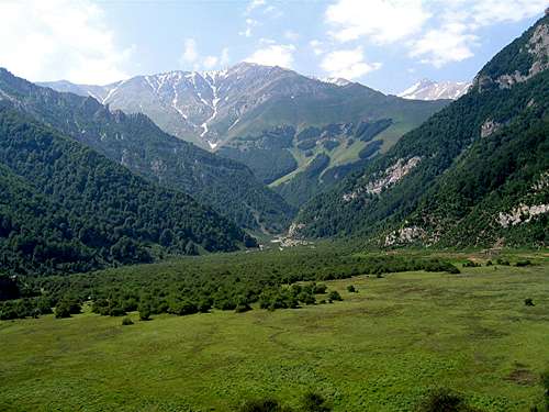
Alamoot Valley
Alamoot Valley
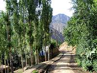
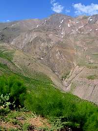
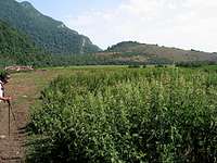
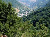
As we continued east, we entered a smaller and much narrower branch of the Shah Rood River Valley known as Alamoot River Valley (You can take a side road from here to reach the historic Alamoot Castle). Just before the village of Haranak (1400 m, 4600 ft), we turned north onto a side road that went up the mountains fairly steeply. This seemed like a pretty wild and remote place to me. The road climbed a mountain that was basically a huge slab of slick rock and then traveled across a slope far above the Atan Rood River. To the south, I could see a number of snowy peaks rising far above the valley. These must have been the Peaks of the Shah Alborz sub-range (4125 m, 13534 ft) Salim told me that this road did not exist some 12-14 years ago when he had come to climb Mt. Siyalan, and they had to start their hike from the bottom of the Alamoot River Valley. The last few kilometers of the road were not paved but the road was fairly smooth.
Shah Alborz:
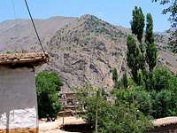
It was around 7:30 a.m. when we reached the village of Haniz (2150 m, 7000 ft) where the road dead ended. This was our trailhead. I have been to many villages in the Alborz Mountains. This, however, seemed like the most rustic place I had ever been.
Haniz Village
Haniz Village
Haniz Village
Haniz Village
The village sat on a mountain slope about 200 m (650 ft) above the bottom of the Atan Rood River Valley. The adobe homes were painted white and seemed to have roofs that were made of logs covered with some sort of a clay material. Tall trees grew everywhere and provided much shade. Electricity had apparently come to this village only about 10 years ago. It was a quiet and charming place. Hardly anyone was on the street.
We had to hike from the village to a saddle (3870 m, 12700 ft) to set up our camp. We were hoping to rent a mule to carry our heavy backpacks to the saddle. For our earlier trip to the Dokhaharan area, Salim had contacted a person in the nearby village and had arranged for a mule and a mule-man. For this trip, he had not done so and I was wondering if that was going to become a problem for us.
We parked at the upper end of the village and started to look for a mule-man. There seemed to be only old men, women and children in the village. They seemed pretty friendly and went to look for people who might have mules. A woman told Salim that all the men had taken their mules to work in the fields and we should have come earlier. Salim laughed and said “Earlier”? We left Tehran at 2:30 a.m. How much earlier did you want us to leave?
In the end, the driver and I stayed in the car and Salim went to look for a mule. I did not want us to get stuck there but I was enjoying the village. An old man came and talked to us for some time. Around 8:30 a.m. Salim came with a man who said he should be able to find us a mule in about an hour. I asked: “will it really be just an hour”? He said: “well I can’t guarantee that but it should not be much longer”. I did not quite believe that.
On our previous trip to the Dokhaharan area I had tipped the mule-man. Salim had scolded me for that saying that my behavior causes the locals to jack up their price for the next group of climbers. For this trip, Salim had earlier told me to stay out of all money matters. To keep their asking piece down, he was certainly not going to tell them that I lived in the United States. He actually told the mule-man that I was a government employee. I thought it was quite funny that twice later he slipped and then immediately corrected himself in a suspicious way. The mule-man was asking for 60 000 Tomans ($66) for the trip (I thought that was pretty reasonable. After all, we had appeared out of nowhere wanting a mule and wanting it right then). Salim went on to tell him that we were mountain climbers with limited resources and we were his guests so he better give us a discount. They finally agreed on 57 000 Tomans.
The old man who had spoken with us earlier invited Salim, the driver and I into his house while we waited for the mule. He took us into what was probably his guest/living room. There was no furniture in the room. The floor was covered wall to wall with Persian rugs and there were cushions all around the perimeter creating cozy places to sit down. The logs that were used to make the roof could be seen on the ceiling and a light bulb was hanging from one of those logs. A few flower pots were behind the window. He had covered most of his upper walls with pictures. There was one picture of Imam Ali (a shiite saint) and two pictures of a young man in military fatigues. This was probably a young relative who served in the Iran-Iraq war in the 1980s. These three pictures were in frames. The rest were posters showing beautiful landscapes, a kitten, a few blond western women and a number of the Iranian actors and actresses (in the Islamic Republic of Iran actresses’ hair is of course covered with a scarf and you only see their faces. I don’t even know the Hollywood crowd so I guess I can be excused for not knowing the Iranian ones).
On one of the actress posters, I saw lyrics that I recognized as those belonging to a song by “Googoosh”, a famous pre-Revolutionary diva in the 1970s. In 2004, when I had taken my fist trip back to Iran, the driver had played a Googoosh CD while we were driving in the mountains. Hearing all those songs that I had heard in childhood had made me very emotional and had caused me to not only rediscover Googoosh but also to associate some of those songs with the mountains. Now she suddenly popped up again in the middle of nowhere during a mountain trip. Her songs remained in my mind during the next few days. I later realized that the poster was that of a contemporary actress named “Mahnaz Afshar” who is famous for resembling Googoosh.
Mahnaz Afshar
Mahnaz Afshar
The old man brought us bread, cheese, yogurt and of course serving after serving of tea. Another old man came and we were talking about local bear and wild boar among other things. As I mentioned earlier, Salim had climbed the southern slopes of this mountain many years ago in autumn. On their way back, they had become stuck in a snow storm but had finally found their way to this village at dusk. He could not remember in which house they had spent the night. He was now talking to the old man about that trip and it turned out that he had come to the same house. The old man said I remember a very religious man who faced the wrong “ghebleh” to do his prayers (“ghebleh” refers to the city of Mecca. Muslims face Mecca (south in Iran) to do their prayers. Salim faces Jerusalem (southwest)). Salim said didn’t you ask the guy why he faced the wrong ghebleh? He then went on to tell the old man that the religious guy was himself and that he was Jewish.
It became 10 a.m. and there was still no sign of the mule-man. The driver said goodbye and the second old man left too. I was getting upset thinking that Salim and the tour company should have pre-arranged for a mule-man to be ready but there was no point in complaining at that time. The old man was saying: “don’t worry it is only a two hour hike to the saddle”. I was thinking nonsense the saddle is 5700 ft higher than the village. For me, that will be at least a six hour hike. Salim had told me to not trust the locals with distances. He had told me a story again and again about how they had once asked a shepherd how far a village was and he had said two hours. They ended up hiking for 8 hours before getting there. I later saw the same story in the mountain climbing guidebook that Salim had authored.
It was becoming late so Salim went to see what happened to the mule-man. The old man asked me if I was looking for treasure in the mountains and if I had a metal detector. He said there is treasure in these mountains from the time of “Daghyanoos” (Meaning old times). He said, a man from their village had found treasure a few years ago and moved away. I was suddenly questioning the sanity of this man. Why did he all of a sudden begin to make such odd remarks? It was not like we were the first climbers here. Siyalan is a fairly popular mountain and climbers come here often. (Sunday is mid-week in Iran so we did not run into any others). After a while, the old man went about his business and I was alone in the room. Although I was very tired, I wanted to keep an eye on our backpacks and did not feel comfortable going to sleep. The people had proven to be very friendly but I thought if I woke up and noticed that something was missing, there would be nothing I could do about it.
It was 11:30 a.m. when Salim and the mule-man showed up. We loaded our backpacks onto the mule. The mule-mans 4-year old son began to cry, saying he wanted to go with his dad to the saddle. The mule-man was telling him he was too little for that. His sister eventually came and carried him away. As we walked through the village, we passed by a bakery where two women were cooking bread. They saw my camcorder and were eager to be filmed so I went in and filmed them.
Juniper trees
Shah Alborz
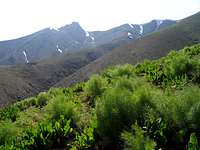
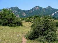
We began hiking at 12 noon and got on a well established trail. Since I wanted to stop often to film and take pictures, I told Salim and the mule-man to go ahead and to not worry if I fell behind. The trail went up the slopes and was at all times a good 200 m (650 ft) or so above the bottom of the valley where the Atan Rood ran. These slopes had a pink hue and were covered with a scattered growth of Juniper trees. I have otherwise only seen these trees in the western United States (Utah, Nevada, lower mountains in Colorado…). The trees and the pink earth made me feel like I was in Utah. To the south, I could see the tips of the snowy peaks of the Shah Alborz Range and this view kept getting better as we went higher. The summit of Siyalan appeared to the north. From that angle, it only appeared to have a few small patches of snow on it.
Salim and the mule-man were going fast and I was falling quite a bit behind but I could still see them above me. My injured ankle was not bothering me much, however, I was beginning to become short winded and was feeling hot. My bottle of water was in the backpack on the mule (oops). I could have dehydrated very quickly but fortunately a breeze began to blow and as we went just a little higher, it no longer felt hot.
At one point, I looked up and saw no trace of Salim or the mule-man. By sheer luck I saw two locals hiking down the trail just a minute later. (Except for a shepherd farther up, those were the only other people we ran into on that day). As I reached the locals, I saw they were wearing netted hood--must have been beekeepers. I began to panic when they told me that they had not seen my partners ahead of me. They told me that the trail for Siyalan went farther up the slopes. I was not going to back track to find the correct trail, so I just began to go up the steep slippery slope. I then heard Salim yelling my name and I began to yell back until we found each other and joined the mule-man who was sitting under a tree. He did not seem happy that more time had been wasted. After all, he had to return to the village before dark.
We started again and I kept getting tired and falling behind. They went faster than me and I kept stopping to take pictures. Well, I came here to take pictures (177 shots in 3 days). There is no point in rushing to the top. It is obvious that filming must be done slowly so that later when you watch it you do not get nauseated. When you are in a hurry, however, you end up moving the camcorder too fast.
At around 2700 m (8800 ft) the trees ended. At first, the slopes appeared fairly arid but a little farther up, the usual growth of small flowery/thorny plants appeared. It was 2 p.m. and around 2850 m (9400 ft) when we reached a small stream and sat down for lunch--which was of course Tuna Fish sandwich. You open a can of tuna, drain the fluid out, pour a bunch of lemon juice in the can, and eat the meat with bread one morsel at a time. This is no national Iranian dish, just a quick and convenient hiking lunch. Like any red blooded Iranian, the mule-man gulped down large volumes of tea at near boiling temperatures (They put the sugar cube in their mouth and sip the tea. Once the cube is gone, they use another one. For some reason, in the U.S, the sugar cubes seem to immediately disintegrate, while in Iran the cubes remain solid in the mouth for a few sips).
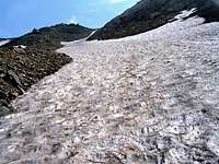
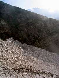
After a 45 minute rest we began to hike again and soon reached a valley that was filled with a long and narrow patch of snow that came from the top of the mountain and went down for hundreds of meters to the bottom of the valley. You could hear a roaring stream under the snow. Months later, when looking at Google Earth, I was able to clearly see this valley.
snow field
Up to that point, the mule-man had been hiking and leading the mule by its leash. He then said that he was getting very tired, his knee was hurting and the doctor had told him not to put too much pressure on that knee so he began to ride the mule. This was suddenly sounding very outrageous to me. Putting a heavy load on a mule and making it go up a steep slope like this is bad enough but adding a 180 lb man was sounding extremely cruel. I almost told the guy to get off the mule but then I thought we (including that mule) were all there because I wanted to climb that mountain. I was comforting myself in the thought that earlier Salim had asked the mule-man how much load a mule could carry and he had said (whatever) Kilograms but the poor animal gets tired. “Gonah Dareh” (translates as “it is a sin”). So he must have some concern for the mule. Maybe that load is not at all unusual. I remembered that I had read about mule rides to the bottom of the Grand Canyon and back. I think they had mentioned a weight limit of 200 lbs for their guests.
We then reached a slope that was covered by a light green bush 2-3 ft tall. The bush seems to consist of stems that lead to needle-like leaves. I have seen this bush in many parts of the Central Alborz Mountains and it has become one of my favorite plants. When wind blows on such a slope the bushes begin to dance, bringing the slope to life. The trail made a series of zigzags going up the slope.
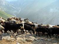
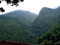
Once we reached the top of that slope (3200 m, 10500 ft), a mountain climbing shelter appeared. Salim and the mule-man were sitting with a shepherd far from the shelter. Sheep herding in these mountains seems to have become the exclusive job of people from Afghanistan. There are an estimated 1.5 million Afghan refugees in Iran. Most of these people seem to be engaged in construction work, sheep herding etc. After the fall of the Taliban, there have been efforts by the Iranian government to return the Afghans to their country with the help of the United Nations Agencies. These efforts seem to have been unsuccessful. I have talked to many of these shepherds and they have all cited lack of security in Afghanistan as the main reason for their reluctance to go back.
Shelter
Menar Cham
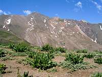
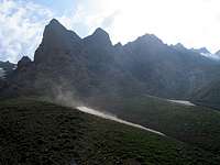
Above the shelter, the trail became pretty steep. It was 4:30 p.m. and I was just exhausted. I was telling myself I must be crazy to put myself through this. For vacation, most people go to a resort town somewhere where they get up late, eat a ton of food, bum around the beach during the day and party all night long. I come here to toil like an animal! Will I go to Florida next year? It is funny how after 23 years of living in the United States, I have still not been to Florida (but I have been to many remote places in the American West). The views, however, were well worth the effort. Now that we were higher, many other snowy peaks had come into view including the nearby Menar Cham (3694m, 12119 ft) and Niar Darreh (3842 m, 12605). The summit of Siyalan itself seemed to have much more snow than had been evident from near Haniz Village.
Niar Darreh
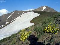
We stopped for another break. The mule-man said he was having a headache. I was sure he had altitude sickness but was surprised that a local would experience that at this altitude. We could now see the saddle not much further up. As we continued up the trail, we were coming across snow fields and the breeze was feeling quite cold. At one point, I saw what looked like a couple of baby goat maybe one hundred meters below me. Were they lost? They were cute.
view from saddle
Siyalan from saddle
As we approached the saddle, I was eager to see the view to the north. Will I get to see the Caspian Sea? (We were only 36 Km, 22 miles away from it). I had my doubts. Two years ago, I had not been able to see the Caspian from the summit of the 4412 m (14475 ft) Kalahoo Peak which is only 34 Km south of the shoreline because clouds obstructed the view. It was 6:00 p.m. when we finally reached the 3870 m (12700 ft) saddle. I ran to the north side to check out the view. Clouds covered the bottom of the valley and everything else was lost in the haze of the late afternoon sun. The mule-man got his money, said goodbye and left. He still had to make it back to the village.
I was extremely tired, but we had to set up the tent. Fortunately there were a number of flat spots created by climbers who had previously come there. It became very cold very quickly. It is nice to crawl into the tent and turn on the gas burner. The soup that Salim made really soothed our cold and tired bodies. He also cooked rice and another dish for me. My right ankle was hurting but it was not too bad. Later when we looked outside in the dark, we could see the light of the coastal communities creating a very distinct curved line marking the Caspian shore. That was really cool. I was too tired and cold to go out to see it. I just looked at it from inside the tent and tried to film it but nothing showed. By 8:30 p.m., we were in deep sleep. We had walked 10.8 Km (6.7 miles) per my GPS.
MONDAY JUNE 26, 2006
As usual, Salim got up at the crack of dawn and said some prayers inside the tent and then went outside to say more. I got up at 5:40 a.m. Moving out of the warm and cozy sleeping bag into near freezing temperatures and not having running water to at least rinse your face is awful. That is why I lose my appetite for breakfast in the mountains. Salim went to fill our water bottles from the trickle of water that exited the bottom of the snowfield below us but that one had frozen overnight so he had to go to a lower snowfield and then come back up. That was a lot of “wasted energy” (for him).
Khashechal & Red Horn
Sub-peaks & snow-fields
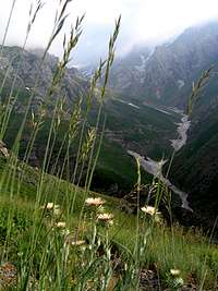
We had breakfast and then left our tent and our heavy backpacks at the saddle and headed east toward the summit of Mt. Siyalan (left at 7:20 a.m.). A trail seemed to follow the top of the ridgeline toward the summit. There were at least two high points/sub-peaks along the length of the ridgeline. On their northern slopes, Siyalan and these sub-peaks created alpine bowls that were covered by large snowfields. As we went up a little, Mt. Khashechal appeared to the west (16 Km, 10 miles away). This mountain turned out to be an impressive peak that rose behind a long and rocky ridgeline. My 1:50 000 map gives Khashechal an elevation of 3945 m but most mountain climbers in Iran say 4180 m (13714 ft). Now that I was looking at it, the higher figure seemed more believable. Much closer, I could see a red colored horn that created an awesome summit. To my knowledge no one has bothered to name this peak. As I was absorbing these magnificent sites, one of Googoosh’ songs (Gharibe Ashena) kept repeating in my head (there is another song whose lyrics can be translated into something like this: “You are like that high mountain which is full of pride…”).
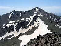
I was waiting for the 4850 m (15912 ft) Alam Kooh Peak to appear to the east. Just below the summit of Siyalan, it finally appeared. What a magnificent peak!
We reached the summit at 8:20 a.m. (2.3 Km, 1.4 miles from the saddle). My GPS showed an elevation of 13760 ft (4194 m). Unfortunately, I could still see only haze in the northern horizon. No sign of the Caspian Sea. Many of the local peaks were well visible. I will only mention a few here.
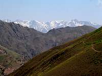
The most impressive sight was of course that of the 4850 m (15912 ft) Alam Kooh Peak and the high peaks of the Takhte Soleyman Massif roughly 30 Km (18 miles) to the east/southeast. It was early morning and the sun was still low in the east/northeastern sky. The view of these peaks was spoiled by the glare of the sun and the haze but I could still identify many of the high peaks. Parts of the Haft Khan and Split Glaciers could be seen at the base of the western wall of Alam Kooh. I had climbed many of these peaks two years ago and had looked at Mt. Siyalan from there.
View of Alam Kooh & The Takhte Soleyman Massif from the summit of Mt. Siyalan
To the south/southeast, the five peaks of the Shah Alborz sub-range whose elevations exceed 4000 m made a long ridgeline that ran east to west. The highest of these peaks is 4125 m (13533 ft) high. Their northern slopes dropped way down to the bottom of the Alamoot Valley (1600 m, 5250 ft).
Shah Alborz
To the west, the 4180 m (13714 ft) Khashechal Peak dominated the view. Caspian rain forests could be seen on the lower slopes of all of the peaks to the north.
Khashechal
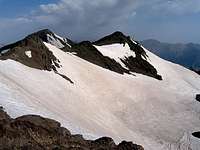
Siyalan
Left the summit at 9:40 a.m. and hiked back to our tent. We then followed the top of the ridgeline west to the summit of Kandigan Peak. There was no trail here but the route was very straight forward (only 0.6 Km from the saddle to the summit). My GPS showed an elevation of 13170 ft (4014 m). The view was for the most part the same as that from the top of Siyalan except that the summit of Siyalan blocked the view of the Alam Kooh massif to the east. The Daryasar Plain, a small plateau in the middle of the mountain slopes (1700 m, 5575 ft), was visible to the north. I could also see a number of alpine lakes a few hundred meters below us. It was now 10:30 a.m. and clouds from the Caspian Sea were beginning to form.
Hiked back to the saddle, packed our tent and put on our heavy backpacks. It had become very windy. We had to descend 2620 m (8600 ft) from the saddle to the Asal Mahaleh Village so we had a long way to go. Left the saddle at 12 noon and began to hike down the northern slopes which were covered by snow. A trail was not visible. My injured right ankle was now beginning to hurt.
View from saddle
Snow-field
View from saddle
Sub-peak
Kandigan
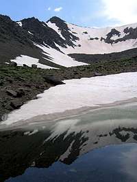
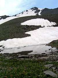
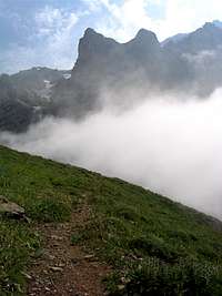
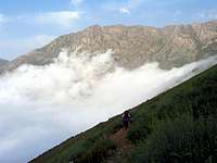
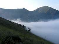
We reached the alpine lakes by 12:35 p.m. (3550 m, 11700 ft). There were may be 10 of them altogether. These were basically snow fields in flat areas that had partially melted. The summit of Siyalan was not visible but Kandigan was in good view. One of the snowy sub-peaks of Siyalan reflected in the lakes creating great views. We sat by one of the lakes and ate our lunch, then I walked around the area taking pictures. Clouds had now appeared overhead and had come to completely fill the valleys below. The tips of the lower mountains/slopes rose above a sea of clouds. From this point on, pieces of clouds began to roll up the slopes creating foggy conditions for a few minutes at a time. As I was standing next to a lake that still had much ice and snow in it, a piece of cloud came above me. It was quite interesting to see ice water and moist sub-tropical air in the same spot.
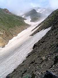
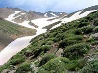
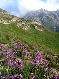
We left at 1:00 p.m. and continued our descent. Below us, the slopes seemed to converge into a tight valley in the far distance. Salim had not been here before but had talked to other people who had told him to stay on the slopes to the east of this valley. Extremely long snow fields seemed to continue into the horizon descending more than a 1000 vertical meters (3300 ft) to the bottom of the valley. Grasses and small thorny plants which had beautiful flowers blanketed the slopes.
Salim suggested that we hike over the snowfields but the snow was very hard and slippery. I fell twice and twisted my injured ankle again making it hurt much more so we moved away from the snowfields. The non-snowy slopes turned out to be just as tricky. The dirt was hard and was covered by small pebbles making it very slippery so we kept switching between snowy and dirt slopes. Heavy back pack made it even more difficult putting a lot of pressure on my ankles and knees. With each step I had to stop myself from tumbling down the slope. The hiking poles came in very handy. I was beginning to hurt quite a bit and had slowed down to a limp. Every few minutes I yelled “picture” and Salim had to wait for me to take a picture and film a little. Our progress had become very slow. Salim was saying if I become disabled here, he will have to shelter me on these slopes and go down to the village to bring a mule to get me down. (Later we ran into spots that a mule could probably not pass). I was worried that at the bottom of these slopes we might come across big walls. The views, however, were absolutely breath-taking.
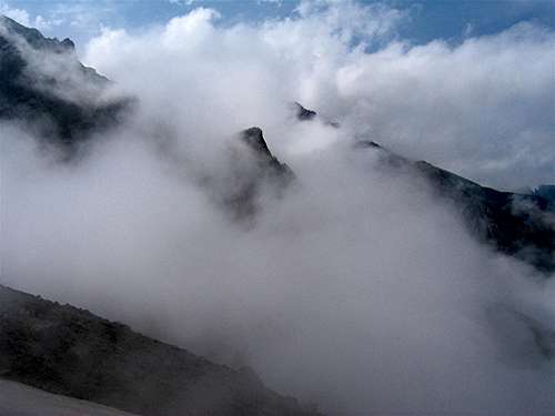
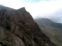
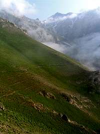
A big blanket of clouds had filled the valleys in front of us making the tips of the distant peaks that rose above it look like Antarctic summits rising above an ice field. Closer, fluffy clouds kept stacking up on the nearby slopes, some of which were rocky or wall-like creating very dramatic scenes. Every now and then clouds came rushing up the slopes toward us like an invading army. They would then suddenly hit us in the face burying us in dense fog before moving away. Behind us, the snowy summits of Kandigan and other sub-peaks made fantastic backgrounds for the slopes that were covered by green thorny bushes and colorful tiny flowers. The long and narrow snow fields that snaked around the otherwise green slopes created a dazzling pattern. Salim, who was always 30 meters or so below me, looked like a tiny ant crawling over a giant canvas by a master painter.
Difficult side valley
side valley
We were down to 2850 m (9300 ft) when we finally reached a trail. I was so glad we found that trail. I could finally stand on firm ground without fear of tumbling down. A narrow valley began to form below us and, as we moved on, the valley became narrower and much deeper. The trail was on the eastern slope of this valley roughly 200 m (650 ft) above the snow covered bottom. I was thinking that the snow field probably went from there all the way to the top of the summits without interruption. The trail had been washed away in a few places and we had to deal with steep gravel covered slippery slopes. We also came across a few side valleys that interrupted the trail. The bottoms of these valleys were covered by very hard snow that we had to traverse. One of these valleys was particularly intimidating. We first had to walk over narrow rocky ledges. Doing so, carrying a huge backpack saddled with bulky tent cover and camera/camcorder bag, and having an injured ankle can become fairly difficult. We then had to traverse a very steep snowfield which was probably the remains of repeated winter avalanches. I had to use my ice axe. The whole thing was no more than 30 m (100 ft) long but was certainly enough to get us killed. Fortunately, that proved to be the last “difficult spot” on this trip.
bottom of valley
Kandigan
The weather had now become fairly warm and very humid. Again, it was quite amazing to see snow under such conditions but these were the last patches. The thorny alpine tundra of the higher elevations had been replaced by an extremely dense growth of grasses and flowers that were soaked with dew. The trail seemed to follow the side of the valley without losing elevation. In some places, it actually seemed to go up a little. Everything below was now lost in clouds and it was not at all clear what laid ahead. It was close to 5:30 p.m. and we were wondering where we will get to spend the night. We had not seen a flat spot suitable for setting up the tent since we left the lakes.
Edge of forest
Fog
At 2650 m (8700 ft) we reached a place where the trail suddenly turned east. Three shepherd and a herd of sheep appeared. These were the first people we had seen all day and the first Iranian (not Afghan) shepherds I had seen during the last several years. They told us there was a flat spot near the river not too far below where we could camp. Salim repeated the story about the shepherd who told him the village was two hours away but it turned out to be 8 hours so we took that info with a grain of salt.
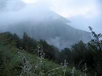
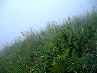
As we began to hike again, we found ourselves on a slope covered with a very lush, wet and dense growth of grasses/flowers that were up to our waists. The first trees were beginning to appear. The trail made one switchback after another going down the slope. The main mass of the clouds was just below us and we soon descended into the clouds like an airplane going into clouds before landing. In the dense fog, we could only see a few meters in front of us but we began to hear a roaring river from below. That was encouraging but soon the sound of the river became weaker until it fainted away. There was just no telling how far it was.
We were getting extremely tired. My leg muscles began to ache a lot masking my ankle pain. I did not know how much further I could go. We were on a slope and could not set up the tent so I kept telling Salim we should start looking for a place to bivouac but he kept saying we must find a stream. We still had maybe less than a liter of water with us and I thought that was enough given the circumstances but he said no. At this point I was getting suspicious that he needed water to rinse his hands for his prayers. It was quite ironic to be on a steamy lush slope where everything was wet but we could not find a single stream.
We could then hear the herd of sheep above us but could not see them. A little later the fog lifted a little and we saw the three shepherds camping farther up the slope. Salim said there must be a spring up there and we should go there. I said if there was a stream there, how come it did not run down the slope? where did it go? He must have gone mad. I told him I was not wasting my energy to go up there. He left his backpack on the trail and started to head up the slope. Soon I heard the shepherd dogs attacking him. I just couldn’t stop laughing. I have had very bad experience with these dogs. They attack anything that approaches the herd. You must firmly stand your ground. If you lose your nerve and run away, they will tear you apart. He soon came down and said they said there was a small stream in the forest “not far below”.
Continuing down the trail, we entered the forest at 2200 m (7200 ft). The trail kept zigzagging down in the forest (which was a forest of deciduous trees and not coniferous trees). It became much darker and we would soon have to start using our head lamps. Salim said he was going faster to find the stream. I simply could not go any faster. My ankle hurt like the dickens with each step. He soon screamed in joy that he had found the stream. I got there soon after him.
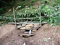
The “stream” was a tiny spring that came out of the mountain at that spot. They had created a small reservoir pooling the water. The string of water that exited the pool was no more than three centimeters in diameter but it was an endless supply of fresh clean water for us. We could at least rinse our hands and face.
The Spring
It was 7:30 p.m. and we were at an elevation of 2025 m (6650 ft) having hiked 14.65 Km (9.1 miles) per my GPS. There was a small clearing in the forest on the banks of the stream but it was still all sloped and there was no place to set up the tent. We had to sleep in our sleeping bags in the open forest. That sounded somewhat worrisome but seemed like quite an adventure that I will remember for years to come. Earlier we had started to hear the river again but had no idea how far below it was.
There was no time to waste. Salim quickly grabbed my ice axe and began to create two small and relatively flat platforms where we could put our sleeping bags. I was getting upset that he was using my nice brand new ice axe to clear rock and gravel. Why does he not use his own ice axe? (His was smaller). Well, he was doing the dirty work so I better not whine.
It became very dark and we had to start using our head lamps. We could see the fog moving around in the beam of light above our eyes. Salim cooked his refreshing soup. I was too tired and was not going to wait for him to cook me a dinner so I just opened a can of tasty chicken meat and ate it.
It was finally time to go to bed. I could see that the platform I was supposed to sleep on was very narrow. If I turned in sleep, I was sure to roll down the rocks and hit Salim who was to sleep a few meters below me. I knew there were bears, wild boars and all kinds of other beasts in that forest. I have a big knife that I usually carry with me into the mountains but since I had not used it before, I had not brought it with me on this trip. I had not even brought the case for my eyeglasses because I had been hanging the glasses from the tent ceiling. It will be very bad if I break my glasses. What if it suddenly starts to rain? What are we to do then? For some reason there did not seem to be any mosquito around and I was very thankful for that
Finally turned the head lamp off and crawled into my sleeping bag in the pitch black forest. To protect myself from wild animals, I put the ice axe right next to me. At first I was somewhat apprehensive but soon came to relax and enjoy the experience. It felt so good to sleep. All my muscles were aching but it was feeling so good. I must have become high on natural endorphins. I was just filled with joy. What could possibly be better than this? As my eyes adjusted to the dark, I began to see the tree shadows. The river could be heard in the distance at the bottom of the slope. I fell asleep but then woke up to feel drizzle over my face. I became concerned but soon found myself waking up again to see a very starry sky above. I was just so happy. Drizzle again and stars again…
TUESDAY JUNE 27, 2006
Salim got up and did his prayers as soon as it began to light up. I got up just before 6 a.m. The sky was clear. With the fog gone, I could finally see where we were and what our surroundings looked like. Across the valley I saw a mountain with big rocky walls that was covered to its top with dense forest.
Trail in Forest
Daryasar River
Tower-like Peak
Canyon Wall
Washed my hands and face in the stream. It was a little cool but was certainly not freezing cold like yesterday morning. I was absorbing all that beauty and was getting very emotional bursting into tears at times. Those songs by Googoosh were in my mind. Wanted to hide my emotions from Salim so kept going to the stream to wash away my tears. He was probably wondering what I was doing.
After having breakfast, we packed our stuff into our heavy backpacks again and left our camp site (2025 m, 6650 ft) at 7:30 a.m. My ankle started to hurt a lot from the very beginning and I limped all day long. The trail continued to zigzag down the forested slopes. The Daryasar River finally came into view. It sat at the bottom of a rocky canyon. We had hoped to reach it yesterday.
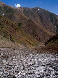
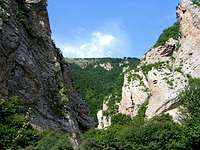
The trail reached the bottom of the canyon at an elevation of 1850 m (6100 ft). The floor of the canyon was fairly wide and was covered by rocks of all sizes. In some places the river split into many streams. The walls of the canyon, in places, had an orange color. Trees and bushes covered most of the walls but some sheer rock faces remained completely bare. One rocky tower-like peak rose on the south end of the canyon.
Canyon
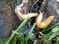
At one point Salim yelled “zaloo, zaloo” (leaches, leaches). I went there to find a couple of giant slugs. I then noted that they were everywhere. The cool and damp canyon floor must be an ideal home for them.
Slugs
The trail followed the eastern bank of the river. We then came across what you could call a shelter. This must have been what those shepherds were
Daryasar Plain
Daryasar Plain
referring to yesterday. They had built a wall next to a rocky slope and put a roof over it. Unfortunately, it seemed like they had lit many fires inside the shelter so the floor of it was filled with ash and it smelled heavily of smoke. There was a picture of a man on a small sign posted on a nearby rock saying in memory of so and so (must have been a climber who died on this mountain) and a two line poem in praise of the beautiful Mt. Siyalan could be found under the picture.
As we continued to head north, the canyon began to open up until we reached a bridge (1800 m, 5900 ft) that took us to the west side of the river. We could not have crossed that river without the bridge. A small plain was beginning to form in front of us at the base of the slopes. This was the Daryasar Plain (1700 m, 5600 ft) which seemed like a geologic oddity to me. Where did this plain suddenly come from in the middle of all these mountains? A hill which looked like a huge pile of eroded rubble sat at the north end of the plain. I don’t know much about geology but was tempted to say that the hill was the terminal moraine of an ancient glacier but the valley did not look like a classic U-shaped glacial valley. The surface of the plain was very flat and the slopes rose above the plain very abruptly. This looked more like an ancient lake bed but what created that odd hill at the north end? While all the other slopes were covered by a dense forest, the surface of that hill remained for the most part bare.
We were soon hiking over the western edge of the Daryasar Plain. The river was on the eastern edge of the plain. Beautiful forested slopes rose to our east and west. The western slopes had some impressive sheer walls that interrupted the forest. To the south, forested slopes that had snowy tops had come into view. There was no forest where we hiked just lush grasses. The trail faded away and the ground became quite boggy in some places. We had to be careful to not sink in the mud. The sun was now shinning directly over us and it had become hot and humid. I had never done serious hiking in hot and humid weather.
A shack came into view in the far distance and we began to hear cows mooing every now and then but never saw the cows. We then reached the shack where there were only a teenager and an old man who had probably brought their cows to graze there. A water trough could be seen outside the shack. Salim went to ask them directions. I was standing outside. Then Salim said there was a cute little calf inside the shack and encouraged me to go inside to film and picture the calf. I hesitated for only a second about entering someone’s shack uninvited but then went to get in. The doorway was very small and my huge backpack along with the ice axe and other bulky stuff that was hanging from it made it difficult but I finally managed to get in. I then heard the old man yelling something in Gilaki dialect (which is somewhat different than Farsi and difficult for me to comprehend). It seemed to me like he said: “would you like it if people walk from the street into your house? If you need to rest, sit out there and we will give you food and water”. I apologized to the man and began to negotiate my way out of that tiny doorway until I got out.
Kandigan
Slopes of Siyalan
We then followed the western end of the plain until we reached that hill on the north end of it where a trail appeared. The trail headed east going up the bare southern slopes of the hill giving us supreme views of the Daryasar Plain with the Snowy slopes of Mt. Siyalan in the background. The summit of Siyalan could not be seen but the summit of Kandigan came into view. What an absolutely breath-taking sight! I have heard that the Daryasar plain becomes covered with wild flowers in late May. At that time of the year the mountains have much more snow. I would love to see that view.
After traversing the southern slopes of the hill, the trail turned back north and continued to travel along the length of the Daryasar River but far from it. We sat there under a tree to rest. The summit of Kandigan was in full view. Kandigan actually turned out to be a more photogenic peak than the higher Siyalan which remained hidden from view.
Kandigan from where we rested
Asal Mahaleh
Asal Mahaleh
From Asal Mahaleh
We then began to hike. The trail went down the forested slopes fairly steeply putting much pressure on my ankles, legs and even arms (using the hiking poles). It was hot and humid. The village of Asal Mahaleh finally came to view below us. Like most Caspian villages, its homes had colorful metallic roofs. I could also see the Dohezar River Valley far below Asal Mahaleh. Across the Dohezar Valley, I could see a gentle mountain slope that seemed to be covered with farms and villages. On the map, I had seen a road that climbed this slope going to a top village called Golestan Mahaleh. I suspect that from Golestan Mahaleh you can have superb views of Mt. Siyalan and Kandigan. On the internet, I had seen a few pictures that I thought must have been taken from that spot ( see See Picture). I wanted to reach there before afternoon clouds obstructed the view.
We went on and on down the trail which seemed to want to stay steep all the way to the end. A “city looking guy” appeared hiking up the trail with his big black pet dog. He said the village was close. He and the people in the shack were the only people we saw on the trail. At last we reached the village of Asal Mahalleh. It was a small place that sat on a mountain slope going from 1300 m (4250 ft) at its south end to 1200 m (4000 ft) at its north end.
We entered its main street which was a wide unpaved street. It was a much more developed place than the Haniz Village where we started our hike but it still seemed like a fairly remote “last outpost” (It really is the last village up the slopes of Mt. Siyalan). We only saw one person on the street. Where was everyone? Like most other mountain villages I have seen, you could see a few nice homes that were probably built as vacation homes by wealthier “city people”. Steep forested slopes rose above the village to the east, west and south. The high mountains could not be seen from the village
We needed a car to take us to the Caspian coastal town of Tonkabon (Shahsavar) but there was no sign of a car or even a person on the street. We had to keep walking down the street. I was getting to the point that I could hardly walk anymore. I felt much pain in my ankle with each step. We could see much trash consisting of newspaper, soft drink bottles, candy/potato chip wraps…on the side of the street. That was a shame.
We finally reached a grocery store at 11:30 a.m. We had hiked 6.75 Km (4.2 miles) for the day and 32 Km (20 miles) for the whole trip. A middle aged man who owned the store was there. His house was very close and his wife and two young children kept coming and going. These village women wear colorful clothes and just a scarf. The odd thing is that the women often have much whiter skin than their men. Some appear like Russian “Babushkas” to me.
We told the guy we had come from the other side of the mountain and wanted to go to Tonkabon. He said at 1:00 p.m., he was supposed to pick up his friend to go to a funeral in a nearby village and he could take us to a road where we could find other ride. I guess we had to wait until then. We bought soft drinks and potato chips (and did not litter) which tasted pretty good. I guess civilization is not such a bad thing after all! Salim asked the guy why there was so much garbage on the street and why they would not get together in their village council to clean up their village. The guy went on to blame the trash on the tourists from Tehran. He said on weekends, all those Tehrani tourists who flood the Caspian coast have begun to wander up the remote mountain roads ending up in villages like this. He said they have started to buy land here. 10 years ago, the price of land was 1000 Toman ($1.1) a square meter, it now goes for 55 000 Tomans ($ 61.1).
It had started to become cloudy. I really wanted to go to that Golestan Mahaleh Village before the clouds blocked the view. I wanted to tell the guy I was going to give him a lot of money if he agrees to take us there now but did not know how to say it without offending him. I finally said it but he said he had promised his friend and could not go any sooner. In the half hour we were there, he got one other customer.
At noon, he closed shop and went home for lunch. We just rested there in front of his store. He came at 12:30 p.m. with an old “Peykan” pickup truck. Salim and I put our backpacks in the back and sat in front with him. There was room for only the driver and two passengers. We drove only 300 m down the main street to his friend’s house. Salim said he was going to the back and told me to stay in the front but I thought it would be another great adventure to ride in the back of a pickup truck so I said I was going to the back too.
We hopped into the back and began to move going down the dirt road on the forested slopes. I was loving it. It had by this time become cloudy. Unlike yesterday when we were far above the clouds, we were now below them. The forested slopes went up into the clouds. The road twisted and turned for 7 Km (4.3 miles) going down the mountains until it reached the bottom of the Dohezar River Valley (800 m, 2600 ft), crossed the river and went up just a little to reach a paved road. I could see some pretty nice homes up the slope there. The guy said to go to Golestan Mahalleh Village we had to get off there to find another car to hitch hike. Clouds had now completely blocked the views anyway. I did not want to deal with having to find a car to take us up there, another to take us to Tonkabon and a third one to go to Tehran, so I said forget it, we will continue with him.
We then got on the paved road that had a fair amount of traffic. He was now driving up to 70-80 Km/hr (50 MPH). I just loved being back there like a puppy dog feeling the strong wind in my face. Kept filming with my camcorder capturing the strong howl of the wind and the beautiful forested slopes around us.
After 10-15 Km we reached a village where we got off the truck. At that point we had exited the mountains and were at roughly zero elevation on the narrow Caspian Coastal Plain. There was a cab agency right on the other side of the street who told us they could take us directly to Tehran. That was good. We did not need to go to Tonkabon.
We then got in the cab. Salim sat in the front and I sat in the back where I could enjoy the views instead of getting into lengthy conversations with the driver. It was mostly sunny on the coastal plain but was very hot and humid. He took us on some back roads until we got on the main coastal highway which runs a kilometer or so south of the coastline. We headed east toward the coastal town of Chalus some 60 Km (37 miles) away. When I was a kid, this road used to be a two lane road that went from town to town. It now appears that the whole southern coast of the Caspian Sea (at least the places that I have recently seen) has become one giant continuous community. Developers have swallowed all the land that they could and built row after row of businesses (not necessarily pretty ones) and vacation homes limiting public access to the beach. This has caused much concern in the media and the government has talked about ambitious plans to “free” the Caspian Sea Coast (It remains to be seen how successful these plans will be). The road had 4 lanes and businesses were right next to it. To the north, we had glimpses of the Caspian Sea and to the south, we could see the foothills that were generally around 1000 m (3250 ft) high and were covered with thick deciduous forests.
We were very hungry and told the driver to stop at a restaurant. I was extremely dirty. My beige colored pants and shirt had become brown with dirt and filth. I had a fresh shirt in my backpack so I did at least change my shirt. In the restaurant’s bathroom, I came across soap for the first time after three days. It is amazing how much black dirty water comes off of your hands and face when you use soap. The driver said he had just had lunch and only ordered a soft drink. Salim, as usual, can only eat kosher meat so in the restaurants he orders salad, bread, yogurt and vegetables. I was the only one who ordered a huge rice and kabob meal with all the extras. That tasted good.
We then got to the coastal town of Chalus and turned south on the Karaj-Chalus Road which crosses the Alborz Mountains in 170 km (105 miles) to Tehran’s side. A few years ago work started on a project to build a divided freeway from Tehran to Chalus. The freeway is to have a series of very long tunnels boring through the mountains under the high passes and cutting the distance from Tehran to Chalus to only 100 Km or so. The project has of course run into all kinds of problems and is way behind schedule. We could, however, see construction work here and there.
South of Chalus, the road gets into the Chalus River Valley and follows the river upstream. As soon as we went into the mountains, it became cloudy again. I really love this beautiful road. I was enjoying the views until the driver suddenly began to play a music tape by a singer from the 1970s named “Golpaygani”. I did not like that at all. Those crappy songs were sounding as bad as I remembered 30 years ago. Every one of those songs is some sort of sob-story. The choice of instruments, make the music sound Arabic and not Iranian. Listening to this stuff makes me think of Saddam Hussein sitting in Baghdad in front of one of his palaces under a couple of palm trees saying “Ya Habbibi”. This was just seriously interfering with my mood but I did not say anything and the tape was finally over and then came peace and quiet again.
The road slowly went up the forested valley until it got into a tight canyon where it eventually made a series of five switchbacks going from an elevation of 1300 m (4250 ft) to 1800 m (5900 ft). It then continued to snake up the mountains even higher going above the tree-line at around 2300 m (7500 ft) until it reached the Kandovan Tunnel 2700 m (8850 ft). This used to be a one lane tunnel built in the late 1930s (roughly two Km or so long) and had a traffic light on each side of it. It has now been widened to a two lane tunnel. I always thought of this as a magical tunnel taking you from the lush green northern slopes, to the arid southern slopes. This time was no different than others. We left a cool, foggy and green environment on the north end of the tunnel and suddenly got into an arid, sunny and much warmer place on the southern side. That sudden change was depressing.
South of the tunnel, the road made a lot of twists and turns descending down to the bottom of the Karaj River Valley (2300 m, 7500 ft) and then went on to follow the banks of the Karaj River south. At least there were a lot of trees on the banks of the river.
We then stopped at a roadside café under the trees by the river for tea. I was still limping quite a bit and was getting worried that I might have seriously damaged something. A couple of buses full of people dressed in Arabic clothes came. These were tourists from the Arab countries. We then moved on and the driver began to play the very same tape again. I thought oh no, not the same thing again! Don’t you have any other tapes dude? This time I asked him to turn it down saying it was really bothering me back there. He said why didn’t you say it earlier, I will play it on my front speakers. At least the sound was now further away from me.
We then reached the long and narrow Karaj Reservoir behind the Karaj Dam. South of that, the road made a bunch of switchbacks going down a slope and finally reached the town of Karaj (say 1300 m, 4250 ft) where we exited the mountains and got on the freeway heading east toward Tehran. As usual, the three lanes of the highway were just jam-packed with cars. As we approached Tehran, the stop and go traffic started.
Salim lived on the west side of Tehran while I needed to go to the northeast. It made much more sense to drop him off first before going to my place. He asked if I felt comfortable giving directions to the driver, I said yes as long as he told me how to get on so and so street.
We first went to Salim’s place and dropped him off and then I sat in front next to the driver. I had not talked to him much up to that point and he was suddenly finding out that I had left Tehran 23 years ago and was living in the United States. I could see he was having doubts that I could find my way around the city. We took Salim’s direction until we got on one of the freeways and then I began to give directions. The traffic was absolutely hideous (as usual). There are so many cars in this city. If there is one inch of free space anywhere, it quickly gets filled by a crazy driver. It was 8 p.m. when we reached my cousin’s place. The poor driver wanted directions back to the highway. (Some of the streets we had driven on were one way). I told him what I could and wished him luck.
It was so good to finally take a shower and wash all the dirt away.
Thank you for your vote and comments. It is intereseting that you mention Salim. I have probably offended him because I kept telling him to get out of the way so that I can take a shot. Despite that, he appears in many of my pictures (because he is always ahead of me). In this trip report, you can see him in the big "cloudy shot" in the middle of the page and in this shot: PIC 1.
He happens to appear in many other shots too, just two more: PIC 2, PIC 3
Thanks for an exciting adventure which few Westerners get a chance to see. There is no other way to get this knowledge and information. Travelling to Iran must be very risky especially for your Jewish guide. We would love the opportunity to do the same and grab the bull by the horns and just do it.
Thank you for spending the time to read this lengthy trip report. I appreciate your vote and encouragement.
I am curious as to why you say "Travelling to Iran must be very risky especially for your Jewish guide". Salim has returned from Israel to Iran on his own free will and is a well-known and respected member of the climbing community. It is my understanding that he along with 40 000 other Jewish Iranians live very peacefully inside the country.
It was just as surprising for me to see that Utah foothills are covered by juniper trees, a.k.a. cedars in these parts. I like to call them "archa" after the more familiar Central Asian tree junipers. They sure look the same. One huge difference though is the other, decidious trees of the foothills. Where are the pistacchios, wild cherries, and apricot trees of Central Asia? Who planted all this useless oak scrub all over Utah instead ;) ?
Good question, I tend to think that due to the fact that large scale agriculture and live stock herding has been practiced for no more than 100 years in the western United States, the vegetation is probably native. In Iran (and probably other parts of Central Asia) 5000 years of uncontrolled human activity has probably altered the natural state of the vegetation.
And thank you for showing another aspect of Iran and its people. Many Americans have a view of Iran as a place of religious fanatics ready to blow anyone up in the name of their god, and many Iranians have equally negative views of Americans. Your TR reminds me of something I've learned on SP: the language of the mountains is universal, as is the love of them. Your TR won't change my views of the politics of the Iranian government, but it does give me a better respect and understanding of the land and its people. Maybe it's naive, but perhaps adversaries should just take a little hike into the mountains together...
Thanks for explaining the tolerance factor in Iran. The American press definately gives one the opposite impression, but there are times when the Iranian government is sensitive to critisism. I understand that the young majority there is opposed to most of the governments policies. I never let politics interfere with my love of the mountains and its people.
I have printed this trip report and will treasure it. Once again thanks for sharing
Thank you Cy. Mixing religion and politics is obviously not a good idea. Iran certainly has a lot of problems but it is not as bad a place as it is commonly portrayed in the west.
of a place I had very little knowledge of. Before reading your TR, I never thought "tropical breezes" and "Iran" could be mentioned in the same sentence.
I actually did Mt Damavand in Iran with Salim two years. I found it fascinating to hear from him about being a deeply religious Jew in the Islamic Republic.
Parents refers to a larger category under which an object falls. For example, theAconcagua mountain page has the 'Aconcagua Group' and the 'Seven Summits' asparents and is a parent itself to many routes, photos, and Trip Reports.


Comments
Post a Comment