Introduction
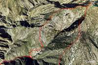
![Iron Mnt Google earth]() Google Earth Image of route
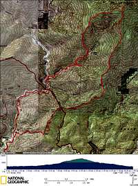
Google Earth Image of route![Iron Mnt ROute Topo Map]() Topo Map
Topo Map
Some months ago I read a trip report in the HPS Newsletter on hiking Iron Mountain (Big Iron) via Allison Gulch and the Southwest ridge. Below are some excerpts of this trip report.
“…I found a nicer, faster and low maintenance route, and have since lost interest in the standard route.”
“So I tried the route, and it worked beautifully.”
“This route appears to be slightly shorter and with less total elevation gain than the standard route, so I was back earlier than usual.”
The Trip Report did warn about the river crossings, 2 sections of bush and some class 3 and 4 climbing involved, but that is nothing new to me so I recruited a willing participant (
Bechtt) and planned to try this route out on 2/10/08.
Well, based on the Trip Report we didn’t see any need for a pre-dawn start, therefore we met at my place at 6 am and made it to the trailhead around 7 am. We were both carrying an extra pair of shoes for the river crossing, ice axe and crampons in case we needed them for when we got into the snow. We did not carry snowshoes. Also, we only carried 3 liters of water each, since previous hikes in the snow I had only been drinking 2 liters or so and thought this would be plenty. So off we went to tackle this "quicker" route to Big Iron Mnt.
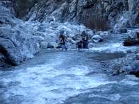
The East Fork of the San Gabriel River:
![White Swan]() White Swan
White Swan![Prospectors crossing River]() Prospectors Crossing River
Prospectors Crossing River
The first foreshadow of what was to come was that the river was much higher than usual. I asked Tom if maybe we should reconsider and hike the standard route, but Tom was committed and wanted to continue. I was happy to know that we were both determined to make this route work. We started hiking along the river following the trail that has developed. Soon we came upon 2 gold prospectors and their daughter (~12 yrs old). They each had a small sluice box strapped to their obviously heavy packs and were attempting a hair raising river crossing. Tom and I were able to scramble around the rocks and made it past them with our feet still dry, however they had poorly chosen the location to cross and were wading waist deep into very fast flowing water. I was nervous that one of them would get knocked over and washed down the river, but they made it. We continued on and I started thinking that these prospectors might know where the mother lode was located; they certainly were continuing on with determination (More on the mother lode theory later). We were soon forced to cross the river as well and there went my hopes of dry feet; there was no way to cross without wading in. However, by choosing good places to cross we never waded in water higher than knee deep. We ended up crossing 4 times and then reached Allison Gulch heading off to the north (just past the Swan).
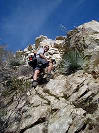
Allison Gulch and Subsidiary Ridge
![3rd class rock nearing summit ridge]() Tom gaining Iron's southwest ridge
Tom gaining Iron's southwest ridge![Talus Chute]() Gaining Iron's southwest ridge via Talus Chute
Gaining Iron's southwest ridge via Talus Chute![Travis ascending to Iron s southwest ridge]() Travis Gaining Iron's southwest ridge
Travis Gaining Iron's southwest ridge![Trail to Allison Mine]() Trail to Allison Mine
Trail to Allison Mine
After our final river crossing we each put on our dry shoes. I had to put my wet shoes and socks in my pack, which added a lot of weight and even though I had them in a plastic bag, ended up leaking water over all of my gear. We made our way up Allison Gulch, which actually had a fair amount of water flowing. There is a use trail most of the way up, which required crossing the creek many times to avoid cliffed out sections. I had my approximation of the route we were climbing in my GPS, but managed to miss the turnoff for the trail to Allison Mine (over the waterfalls, which we had previously descended.
See Trip Report). We came to the point of junction between 2 canyons and then looked at the GPS and realized that we had gone a ways past the junction. The HPS trip report stated that the waterfall is just a short distance past the turnoff, when actually it was quite a ways past. We backtracked down the gulch for a ways. Then Tom decided to climb the ridge to try to intersect the trail. I saw what he was doing and decided to do the same rather than backtrack back down. I ended up climbing a very steep, tiring scree chute and some 3rd class rotten rock in order to gain the ridge. Tom had to traverse over the same rotten rock. This slog tired me out, I need to make a point of eating breakfast before hiking, which I had not done this morning. We quickly found the trail and was amazed at how well maintained it was. It had nice switchbacks with water drainage channels, yucca were nicely trimmed, a very nice trail indeed. This got me thinking why someone has been going through the trouble of maintaining this trail. It is not a frequent destination of hikers. My conclusion is that it is maintained by gold prospectors. If miners went through the trouble of building Allison mine at such a difficult to reach location then there “must be gold in them there hills” and I feel that there must still be a significant quantity left (maybe even the mother lode). After about 1 mile switchbacking up around the waterfalls of Allison Gulch we reached Allison Mine. This is a very interesting spot but we did not have time to explore, but could see the remnants of the mine from the trail. According to the trip report we were to gain the subsidiary ridge immediately to the northwest once the trail turns towards Allison Mine. We found a talus chute and figured this was it and headed up. The talus chute was a slog and we quickly made our way out of it to more solid ground. From there we just kept going up and up, avoiding bush and yuccas (each of us taking a few stabs) and heading towards Iron’s main souwthwest ridge. It was slow going up this ridge. Near the top it presented some pretty sustained 3rd class (but no 4th class). We never needed to put away our trekking poles so that was an indication that it was not that difficult. The rock quality improved as we ascended as well. After what seemed like a very long time we gained the main ridge. OK this is where we thought things would get easy. But no such luck.
Iron’s Southwest Ridge
![Iron s southwest Ridge - nice view]() Iron's Southwest Ridge under heavy snow
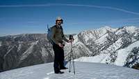
Iron's Southwest Ridge under heavy snow![Travis on top of Iron Mnt.]() Travis on Iron Mnt Summit
Travis on Iron Mnt Summit![Corniced Ridge]() Iron's southwest ridge (corniced)
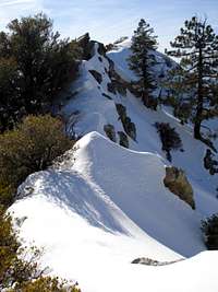
Iron's southwest ridge (corniced)![Iron s southwest Ridge]() Iron's southwest ridge
Iron's southwest ridge
Once we gained the ridge we both realized that we had not brought enough water. I checked my bladder and was surprised to see I only had about
½ litre left! And we still had a LONG ways to go. I packed my bladder with some of the slushy snow we were now encountering; Tom did the same. I placed the bladder in my pack so that it would rest along my back and hopefully melt from the heat. This worked pretty well and the ice cold water never tasted as good. The ridge did not let up and continued to present us with sustained sections of class 3 climbing. Immediately in front of us was a large bump along the ridge. We had hoped once we scaled up this bump we would reach the “enjoyable” section that was described in the HPS trip report. But again, no such luck, at the top of this bump we were forced to lose a significant amount of elevation and had to climb up another bump, this one pretty heavily bushed as well as rocky. The snow was also starting to get deep, and it was wet and slushy. Then we hit some of the nastiest bush ever at the saddle between bumps and it was Tom’s favorite, Buckthorn. To make it worse, this saddle was in the shade and the snow very deep. Bushwhacking in 4 feet of snow is tough. As soon as you try to launch over the bush, you sink up to your crotch. We lost a lot of valuable time in this bush and snow, and now I checked the time and was surprised that it was already 1 pm. We should be at the summit by now and we still had a long ways to go. Being that it took us 6 hours to reach this point, we figured we were still better off to push for the summit and descend the usual route. I knew we could make it down in 3 hrs and figured we should be at the top in 2 hrs. This ridge continued to offer more of the same and just wouldn’t let up. One bump after another and more bush and 3rd class rock. Plus, the snow was getting deeper and we were doing a lot of postholing. We were exhausted when we finally reached the summit at 3:30 pm and didn’t even bother to dig out the summit register. We were surprised to see that no one else had been up here since all the snow and that meant we would have to break trail on the descent as well. But, the views were amazing and the weather couldn’t be better. We had completed a very challenging new route to a very challenging summit and felt a sense of accomplishment.
Descent via Heaton Flats Trail
![Sunset at Helicopter Landing Pad - Iron Mnt Trail]() Helicopter Pad on Iron Mnt. Descent
Helicopter Pad on Iron Mnt. Descent
We rested at a tree just below the summit and ate lunch. We knew we would need the fuel for the descent. We could see the ridges that we had to descend and the snow was deep and corniced. Plus, our feet were soaked and cold. We wrung out our socks and I put in a couple of heating pads (which immediately got soaked and didn’t work). I was in a rush to get down, my wife expected me home by now (I should have known better, but I told her I would be home by 4 pm) and I wanted to at least get down the steep section before dark. I lead most of the way down. Some sections were steep and firm enough were I could do short sections of glissading, however most required deep plunge stepping. I found if I ran it took less energy since I had to posthole less often. However, I chewed up my shins pretty good, continually smashing through the top crust of the snow. Despite this snow, we made good time. Up and over the bumps and took a break at the helicopter landing pad just as the sun was setting. Beautiful views. Plus we could see our ridge pretty clearly. The ridge we climbed to join the main southwest ridge looked unclimbable from this vantage point. Shortly after we switched on our headlamps (after all these years of carrying my headlamp on every trip I finally got to use it) and set a fast pace down the main trail. We made it back to the car just before 7 pm. We had been hiking for a solid 12 hours and we were beat. I rushed Tom into my car and sped off home so I could get cell reception and call my worried wife. She wasn’t too mad at me, but wants me to get a PLB.
Hindsight is 20/20
![OUr route up Iron s southwest ridge]() Our Route in Red - Iron Mnt.
Our Route in Red - Iron Mnt.
We definitely got more than we bargained for on this outing. This was one of the more difficult hikes I have ever done. We knew from the research that this ridge was not going to be easy, but we allowed ourselves to underestimate what we were getting into based on reading a Trip Report. I am not sure if the author of this trip report was joking when he said that this route was shorter, quicker and “worked beautifully” but regardless this goes to show that the source of beta should always be questioned and what could be easy to some may not be so to others. I still challenge anyone to hike to Iron via this route faster than they could using the standard approach. I say it is Impossible! Tom and I are proficient in bushwhacking, competent on 3rd class and are fast and it still took us over 8 hours to reach the summit! I do not recommend this route for average hikers. However, the views were amazing and it definitely offered a lot a varying terrain and challenge. For the select few who enjoy pushing the limits and trying new routes this may be a route for you, but please
proceed with caution.
Additional Information
Ongoing Discussion:
http://sangabrielmnts.myfreeforum.org/about251.html
GPS data and Google Map.
http://www.gpsmountaineering.com/ironmountainviasouthwestridge
More Photos:
Travis':
http://www.flickr.com/photos/trav_and_jenn/sets/72157603888411642/
Bechtt's:
http://www.flickr.com/photos/becht/sets/72157603887733894/


Comments
Post a Comment