Intro
Twin Peaks in the Sangres has been on my short list to climb for quite awhile. One day while researching it I discovered there were only 10 ranked summits in Alamosa county and I had already done 7 just by pursuing the 14ers and 13ers! A weekend trip was in order to get the other 3! Ryan Kowalsky and Pete Krzanowsky would join me on Twin Peaks while John and Renata Collard are always up for obscure 12ers, so they were gracious enough to join me for the slope up North Zapata Ridge.
SlideshowTwin Peaks A: Up, Up, and Away!
Twin Peaks A (13580')
7.7 miles RT, 4800’ gain
From Zapata Falls TH (9040’)
I got gas in Walsenburg and coincidentally Ryan and Pete pulled up as I was leaving! I got a convenience store sausage and egg biscuit for some energy. Hopefully that wouldn’t come back to bite me. Ryan got one as well, so we had no excuse for being slow!
The Zapata Falls TH is signed from CO-150 and the road is in great shape, even for 2WD. This is the same TH for centennial California. We set out at 7am under partly sunny skies and 38 degrees. It was nice to be starting out with just a soft shell for once! We followed the trail which was packed down initially by the tourists heading to Zapata Falls. We took the short detour to the falls and saw 3 bighorn sheep on the cliff face. The falls were looking a bit thin and were starting to melt out.
We left the trail not too far above the falls at 9300’ and gained the ridge crest after bashing our way up brush and deep sugar snow on a north facing slope. Once on the ridge, we enjoyed dry conditions for awhile until we entered the taller aspen trees.
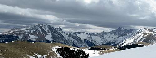
![Twin Peaks (Sangres) n.e. ridge]() The long n.e. ridge of Twin Peaks.
The long n.e. ridge of Twin Peaks.<
We donned our snowshoes at around 11K’ and encountered rotten snow anytime we ventured onto north facing aspects. We contoured onto the firmer south facing aspects when we could, but generally followed the spine of the ridge.
We were eager to get out of the snow onto the wind blown talus at treeline, but we would now take a shot from the wind. We took a break at treeline as things were about to get steeper. I was now beginning to feel the effects of not being up high in over a month, and started to fall behind. Could it be the breakfast biscuit? The biscuit made its presence felt and I had to visit the little boys room amidst the talus. What a cold pit stop it was, but now I can pick up the pace! As we ascended the ridge, we enjoyed spectacular views over to California, Blanca, and Ellingwood.
![Ellingwood Pt from Twin Peaks]() Ellingwood Point from Twin Peaks
Ellingwood Point from Twin Peaks
The ridge was mostly windblown talus with patches of snow until we got higher, where the snow was rock hard. I finally crested the steep part and saw Pete about to summit, which had a nice cornice over the east face. I topped out at 12:45 and we were treating with a staggering view of Little Bear!
![Little Bear n.w. face]() The n.w face of Little Bear from Twin Peaks. Looks a little sporty right now!
The n.w face of Little Bear from Twin Peaks. Looks a little sporty right now!
The winds were strong enough to keep our stay at only 10 minutes, so we headed down. The descent as usual was more painful than the climb. We descended the long talus strewn ridge back to treeline where we welcomed getting back on snow. The snow soon wore out the welcome as postholing commenced. We all took our turns in the misery and lost our tracks briefly for a few times, but the GPS did the trick.
Finally back on dry ground we could ditch our snowshoes and cruise down. We made it back to the cars at 4:27 as a group of tourists couldn’t believe we had been to the summit of Twin Peaks! I must say this is one of the best eye candy hikes in the Sangres. It’s well worth the trip!
High Dune: Slippin and Slidin
High Dune (8691')
2.3 miles RT, 700' gain
From picnic area (8060')
I was pretty beat after the big day on Twin Peaks, so I wasn't looking forward to more vertical on High Dune! High Dune is the only ranked summit in Alamosa county below 12K', so I'm surprised even the great Mike Garratt hasn't finished this short list. I paid my surprisingly cheap fee of $3 to get into the park and downsized my pack and attire for this short hike.
I was off at 5:15pm as a stiff wind greeted me on the flats, just as windy as up high earlier in the day. I didn't do much research on this hike and accidentally erased my summit waypoint earlier in the day, but hopefully I could figure out which one it was.
![High Dune from trailhead]() High Dune looking mighty fine from the trailhead.
High Dune looking mighty fine from the trailhead.
I pretty much picked the path of least resistance on the way up, connecting ridges as the sand was more firm there. In my haste to beat sunset, I left my trekking poles in the car. The times I had to leave ridgelines to connect to the next were tough work in my sandles. My quads were crying for mercy, but I knew the reward would be the descent!
![Nearing summit of High Dune]() Nearing the summit on the n.e. ridge.
Nearing the summit on the n.e. ridge.
There were quite a few tourists sliding down the lower dunes with boogie boards or plastic sleds. I should have brought one! I finally crested the main n.e. ridge and from there it was just a few hundred feet to the summit. The spine of the ridge was cool to walk across as you would create tiny sand avalanches below you. A group was on the summit doing backflips off the summit onto the face!
The wind was pretty stiff up here, but the views were incredible. I ate the rest of my rice crispy treat and probably ate a fair amount of sand with it.
![Sanddrift on High Dune summit]() A little "sanddrift" on the summit of High Dune.
A little "sanddrift" on the summit of High Dune.
I only hung around for about 10 minutes and couldn't wait any longer for the plunge stepping fun down the ridges. I took a direct descent back down to the car. I tried sand glissading, but it was too thick to gain any momentum. I bombed down to the flats in no time at all and it really stretched my legs out from the long day. I was back at the car at 6:27 in time to meet John and Renata at the Pinon Flats campground and setup my tent before dark.
North Zapata Ridge: Another Rollercoaster Ridge
North Zapata Ridge (12330')
9.6 miles RT, 4760' gain
From Cedar Ridge Rd (8450')
This relatively obscure ranked 12er was all that was left to complete Alamosa county, but it was a tall order with its seemingly never ending west ridge. We went to bed early and got a good night sleep as it dipped down to just 40 degrees. I met a local on 14ers.com who owned property in the gated community at the base of the ridge. He was gracious enough to meet us at the entrance and led us to a spot where we could start. Otherwise you would have to do this peak from the east side.
We set out at 7:15am from Cedar Ridge Rd. There are several ridges that fan out from the main west ridge of N Zapata, but my contact Pat had been up it several times and told us to go up the ridge to the north of N. Zapata Creek. The other neighboring ridges appeared to be much more rugged.
The ridge wastes no time in gaining elevation, and I felt very sluggish from yesterday. The bushwacking wasn't too bad lower down, but things would quickly get tougher as we climbed. After about 1000' ft, we came to a cool class 3+/4 section. John and Renata went left, while I took a slightly steeper line that had a couple trees in the way that I used as belays. I ripped out the inseam of my pants on one of the awkward moves, so things were a little airy the rest of the day! A few minutes further up the ridge and we came to another class 3 ledgy step, but it was easier.
The ridge was mostly dry until we started hitting patches of snow around
10K', but we reluctantly kept the snowshoes on our backs until the postholing was slowing us down too much. It is pretty hard to screw up with the routefinding as all you have to do is use the cliffs on the south side of the ridge as a handrail. We had some pretty awesome views of the gorge below.
![Cliff bands on N Zapata west ridge]() Dramatic cliffs ring the south edge of the west ridge of North Zapata.
Dramatic cliffs ring the south edge of the west ridge of North Zapata.
We made better time with the snowshoes, but the bushwacking got more annoying as we had to weave around a lot of obstacles. The bumps started to add up as well, as there seemed to be more than what was depicted on the map. The snow was in decent shape the higher we got, but there was enough postholing to wonder what was going to happen with your next step!
It took FOREVER to finally reach treeline. I was starting to get that AC/DC song in my head with the bagpipes, "It's A Long Way to the Top." We left our snowshoes on until we came to the final saddle. I pointed to the summit and John and Renata couldn't hardly believe that was finally it.
![North Zapata summit]() Finally nearing the summit of N Zapata Ridge.
Finally nearing the summit of N Zapata Ridge.
The wind picked up quite a bit for the last half hour or so, but it wasn't cold enough for a balaclava. We topped out at 1:45pm and continued right over it to the leeward n.e. side, taking shelter below a small, harmless cornice. I devoured as much food as I could in anticipation of a death march down.
![Lindsey and Blanca group]() Lindsey and Blanca groups minus Little Bear from N Zapata Ridge.
Lindsey and Blanca groups minus Little Bear from N Zapata Ridge.
We were toying with adding nearby unranked Carbonate, but that would have added at least an hour. We still had 440' vertical on the descent with more postholing. The views were outstanding from the summit of the Lindsey group, so maybe it was worth the effort. We cruised back down to our snowshoes and put them on for the long battle back to snow line.
John led the way initially and was busting through a lot, so he made me the posthole slave since I'm lighter. Renata took over the chores after awhile and she floated across stuff that John and I couldn't. John broke one of his snowshoes and turned an ankle as a result. He put a brace on his ankle and felt better, so we were glad we didn't have to setup a bivie!
We finally got down to where we could ditch the snowshoes, but the ups and downs were tough. The lower class 3+ downclimb was a bit interesting as I had to face in looking for footholds. From there, the ridge dive bombed down to the valley and we were stoked to finally see the road! We staggered back to the car at 6:30pm, an 11 hour plus day for one peak!


Comments
Post a Comment