
|
|
Route |
|---|---|
|
|
27.81830°N / 86.71300°E |
|
|
Spring, Fall, Winter |
|
|
A few days |
|
|
Class 3 |
|
|
Class 3 |
|
|
Overview
This route climbs Jaro Ri from the rugged west side. I do not know if it is the easiest route, but it is a good route. From the monument/gate west of the peak (between Namche Bazaar and Khunde), the route makes its way through the boulders and around cliffs to the summit. There is a path in a few places, if you can find it, but we didn't see much of it until the way down. This is a surprisingly rugged and fun climb.If coming from Namche on a day trip, plan on a half a day excursion, including seeing the villages of Khunde and Khumjung.
 Summit of Jaro Ri.
Getting There
The climb of Jaro Ri begins In Namche Bazaar, Khunde, or Khumjung (which the two latter are reached from Namche Bazaar). Namche Bazaar can be reached on foot from several directions. The two most popular routes to Namche Bazaar are from the trail from Lukla Airport or the walking route from Jiri and Bhandar.As of December 2012, only Sita Air and Yeti Air (which are basically the same company) fly to Lukla. Namche Bazaar is two days on foot from Lukla, and most people spend one, two, or more days acclimatizing in Namche Bazaar before heading higher to other areas, which is a very wise move.
Be aware that flights to Lukla can only fly in good weather and that sometimes planes are grounded for days.
The walking route from Bhandar to Namche Bazaar takes 8-9 days plus a long day’s bus ride from Kathmandu. Twelve buses a day leave from Kathmandu and from Jiri usually transport can be found to Bhandar.
 Khumjung Village with Ama Dablam in the background.
Approach - Lukla to Namche Bazaar
From Lukla, the main trail heads north and down to Cheplung. From here the trail continues along the Dudh Kosi River and ascends to Ghat and Phakding. Most people spend the first night here, but if you have time, I'd recommend continuing another hour or two to Benkar. This helps spread business between places that are normally used as overnight stops and allows a quieter experience as well. There are a few nice waterfalls around Benkar as well.From Benkar, the trail crosses the river and a bridge and ascends gradually to Chumoa and Monjo. It is here that you will have to show your permit and this is the first of many checkpoints. Jorsale is just beyond and is the last town before the long, but fairly gradual climb to Namche Bazaar. About 2/3 of the way up is a viewpoint with your first views of Ama Dablam, Everest, and Lhotse.
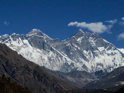 Everest and Lhotse from near Jaro Ri.
Route Description from Namche Bazaar.
From the northwest corner of Namche Bazaar, locate the main trail that heads north towards Khunde (any lodge or cafe can point you in the right direction). The trail climbs many stairs up to the Syangboche Airstrip.From Syangboche, stay north on the main track towards Khunde. Just north of the village of Jaro and not far before Khunde is a Chorten and minor pass. Jaro Ri can be seen clearly to the east.
Head towards the peak. At first there are some pretty good trails, but as you climb on the slopes of the mountain, the route becomes much more difficult with some tricky scrambling in some huge boulders. Keep an eye out for Himalayan pheasants in the area.
There are some definite class 3 moves in the boulders and places there may be a track, but it is hard to find. Once on the summit, enjoy the fine views.
The east side of the peak looks equally challenging.
This excursion is an easy three hour trip from Namche Bazaar, but you can easily make it into a half day or even full day side trip by climbing Jaro Ri with the villages of Khunde, Khumjung, and the Hillary School.
 Jaro Ri summit. Kantega and Thamserku are in the background.