
-
 5166 Hits
-
 73.06% Score
-
 3 Votes
|
|
Route |
|---|---|
|
|
36.49910°N / 115.94776°W |
|
|
Hiking, Bouldering, Mixed, Scrambling |
|
|
Spring, Summer, Fall, Winter |
|
|
Half a day |
|
|
Difficult |
|
|
Overview

Getting There

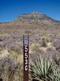
NOTE: This should be done in a high clearance vehicle. Once you are there you might be tempted to take 553A North instead of going back to 553C and back onto 553. There are some areas just around the parking area where if one isn’t careful you could tip your vehicle over the side. I highly suggest driving out the way you came in.
Waypoints
| Waypoint | Latitude | Longitude |
| WPT 1 | 36.49272 N | 115.9455 |
| WPT 2 | 36.4946 N | 115.94736 W |
| WPT 3 | 36.4989 N | 115.94933 W |
| WPT 4 | 36.49888 N | 115.94897 W |
| WPT 5 | 36.4991 N | 115.947764 W |
| WPT 6 | 36.499277 N | 115.9480277 W |
| WPT 7 | 36.49833 | 115.948611 W |
 |  |  |  |  |
Descriptions
WPT 1 Park
WPT 2 Rocky Outcrop; go to the right side of this
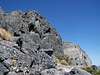
WPT 3 Base of the main Rocky Outcrops below the ridge, and South of the main cliff
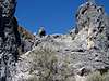
WPT 4 Gulley needed to gain the ridge
WPT 5 Summit
WPT 6 A gulley you can go down, not far past the summit on the way down, 1st gulley you see on your left when coming down from the summit.
WPT 7 Two little rocky outcrops here, go to the left side of the 1st one, then turn right 90 degrees and hike 40 yards or so then turn and go back down the scree.
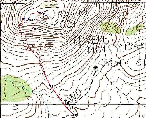 GPS Trace
Route Description
Refer to the Waypoints above for some specificsFrom your vehicle head straight NW up the ridge towards the rocky outcrop you see. Hike to the right side of this outcrop and then continue NW up the scree. Make switchbacks if you need to up the scree. You might find yourself in a lineman stance hiking up at some points. Refer to the waypoints if needed.
Continue hiking up towards the rocky outcrops that are below the ridge and to the left (west) of the big cliff. Once up here scramble through some easy class 3 sections. Hike and scramble towards the big cliff looking for a gulley to go up and gain the main ridge below the summit. Waypoint 4 and 6 can be used as gulleys, however, waypoint 4 will be the 1st one you come to and the recommended one. Once you get through this gulley you will be on the main ridge and it’s a short stroll slightly NE to the summit.
On the summit you can find a register under some rocks next to the Jaybird Benchmark. While on the summit take a look SE over the cliff. It’s a nice straight drop off. You have a good view of the Sheep Range to the east, Spring Mountains to the southeast, Mt. Stirling to the South, and Mercury and the Nevada Test Range to the North.
Return Hike
 WPT6
WPT6Soon you will come to the rocky outcrop past the scree. Stay to the left of this and hike the last 0.18 miles down to the vehicle. Remember to drive out the way you came in.
 WPT7
WPT7