
|
|
Route |
|---|---|
|
|
28.86084°N / 90.13561°E |
|
|
Mountaineering |
|
|
Spring, Fall, Winter |
|
|
Expedition |
|
|
F-PD (high altitude glacier route) |
|
|
1. Overview
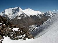
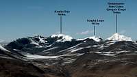
 Summit ridge of Jitan Zhoma (6004m)
The route ascending the northwest face of Jitanzhoma (Jitan Zhoma) can be qualified as the normal route on this easily accessible 6000er located south of Karo La, in the Lhagoi Kangri belt. The climb offers extraordinary views on its two highest neighbours Noijin Kangsang (7206m) and Kaluxung (6674m).
From the starting point at 4830m on the main road Gyantse – Lhasa, the route heads south in a small lateral valley. At an altitude of 5280m, the valley forks, and two options are possible either on the left or right branch of the valley. Both routes join again at a small col (altitude 5737m) on the upper part of the northwest face of the peak. Depending on conditions, the summit ridge can have some very short exposed rock/snow parts on loose rocks or cornices.
Except the exposed summit ridge, the climb is straightforward and does not present technical difficulties. The glacier on the NW face appears as virtually free from crevasses, so the route is quite attractive for small parties or solo climbers without rope.
The route can be climbed all year round, but it is better to avoid the monsoon season (summer) when the whole area is prone to sudden weather change. However, route conditions can vary significantly (see below, When to climb chapter). With an elevation above 6000m, Jitanzhoma remains a serious endeavour and a minimum of acclimatisation is required; it can however also represent an interesting acclimatisation trip before attempting neighbouring Noijin Kangsang. For an acclimatised party, the summit can be reached within less than three hours from the Base Camp.
There is only one report of a previous successful climb of Jitan Zhoma, realised in 2008 by SPer Corax via the East Couloir Route, however I found some old bolts and ropes on the summit rocks indicating that the peak has been climbed meanwhile by other expedition(s).
2. Getting There
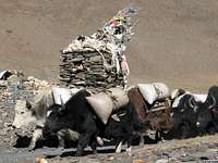 Yak caravan passing Karo La (5036m)
See the Lhagoi Kangri East area page and/or Jitanzhoma main mountain page, getting there section, for the approach to the peak from Lhasa (190km) or Shigatse (160km).
The route start around 6km west of Karo La on the main road between Gyantse and Lhasa (road S307), at the point where the road makes some switchbacks in order to join the bottom of the valley. The road marker indicates 126km, which represents the distance from the beginning of road S307 at Chusul bridge in the Yarlung Tsangpo (Brahmaputra) valley.
A small side valley (“Zhomu Gulley” on the map) leads south directly to Jitanzhoma, which summit can be spotted from the road. Starting point can be on both side of the stream, at an altitude of 4830m.
Coordinates for the possible starting points:
Option A. East side of the side-valley (left-hand side): Lat 28°54'10"N Lon 90°07'28"E, altitude 4830m
Option B. West side of the side-valley (right-hand side): Lat 28°54'05"N Lon 90°07'20"E, altitude 4830m
3. Route Description


From the road to the Intersection at P5280m
Option A: East (left) side of the Zhomu valley. From the starting point on the roadside, follow a loosely defined path on the left hand side of the river. The path rapidly gains elevation, and after about 1km the entire Zhomu valley becomes visible, with the majestic North face of Jitan Zhoma closing appearing at the far south (P5042m). Staying on the left side of the river, continue for another 2km up to the intersection (P5280m) where the valley divides itself into two branches: the eastern upper Zhomu valley heading towards Jitanzhoma north face, and the western upper Zhomu valley heading towards Jitanzhoma northwest face.
Option B: West (right) side of the Zhomu valley. From the road, head upstream staying on the right-hand side of the river, through some dense thorn bushes or just following the river bed. Reaching the small shelter for nomadic herders at an elevation of 5084m, Jitan Zhoma appears at the end of the valley. Continue on the right side of the river, until P5280m.
| From the road to the Intersection at P5280m | ||
|---|---|---|
 1. Zhomu valley 1. Zhomu valley 4830m Starting point of the route |  2. Zhomu valley & Jitan Zhoma 2. Zhomu valley & Jitan Zhoma 5042m Eastern side of the valley |  3. Yak & sheep shelter 3. Yak & sheep shelter 5084m Western side of the valley |
From the Intersection at P5280m to the Col at 5737m

At P5280m, the two approaches on both sides of the river join again, and the valley forks into an eastern (left) and western (right) branch. Both options are possible, the eastern one being more scenic with fine views on Jitan Zhoma north face, while the western option is more direct. I recommend the eastern option, but will describe both of them here below. Both variants join again at col 5737m, on the ridge separating the north face from the northwest face.
| SE – S – SW panorama from intersection Point 5280m | ||
|---|---|---|
 4. Eastern branch (SE) 4. Eastern branch (SE)5280m Peak 5861m visible to the left | 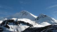 5. Jitan Zhoma (S) 5. Jitan Zhoma (S)5280m N face (shadow) and NW face (sun) |  6. Western branch (SW) 6. Western branch (SW)5280m Valley leading to the NW glacier |
Option A: East (left) side of the Zhomu valley
From P5280m, head southeast for about 1km, until you reach the wide flat valley floor at the bottom of Peak 5861m West face and Jitan Zhoma North face. This is a suitable location for establishing camp, at around 5400m (see GPS coordinates below). In the warmer months, running water is available from the small stream, or in form of ice during the colder season.
 7. Camp 5404m 7. Camp 5404m with the climbing route up to col 5737m in the background |
From the camp, two routes are possible to reach the col at 5737m, either crossing Jitan Zhoma North glacier, or following the snowfields below the small rocky prominence (P5776m) located to the right of the col.
After the heavy snowfall of the late 2010 monsoon, I found the last stretch on the glacier to be avalanche prone, and after reaching an altitude of 5650, I preferred to turn back and climb via the safer snowfields. However, during drier years (as well as during late winter & spring), the snowfields might have melted and the ascent on the steep scree will become unattractive, so at that time the glacier will provide the better option.
| Option A1. From Camp 5404m to Col 5737m (following Jitan Zhoma North glacier) | ||
|---|---|---|
 8. Jitan Zhoma North glacier 8. Jitan Zhoma North glacier5481m Start of the glacier | 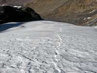 9. Jitan Zhoma North glacier 9. Jitan Zhoma North glacier5580m Looking down (north) in the valley | 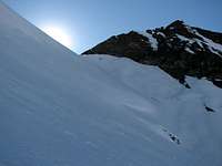 10. Jitan Zhoma North glacier 10. Jitan Zhoma North glacier5604m With col 5737m and P5776m |
The alternative route goes to the right side of the glacier and passes below the prominent Point 5776m. In the conditions I found (November 2010), the climb was eased by a good layer of snow, and limited risk of rock fall. Once reaching the col at 5737m, the route joins with the other route described below (option B).
| Option A2. From Camp 5404m to Col 5737m (following the snowfields below P5776m) | ||
|---|---|---|
 11. Point 5576m 11. Point 5576m 5455m Seen from the NE | 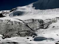 12. Jitan Zhoma North glacier 12. Jitan Zhoma North glacier5548m Seen from the W |  13. Reaching col 5737m 13. Reaching col 5737m 5668m Seen from the N |
| Option A2. Overview of the route from Camp 5404m to Col 5737m | ||
|---|---|---|
 Seen from the W |  Seen from above | |
Option B: West (right) side of the valley
From P5280m, head south for about 1km up to a dry glacier lake, where Camp 5377m can be established. Depending on the season, the snowline is another 0.5 – 1km further up, at an altitude between 5500 and 5600m. Jitan Zhoma NW glacier itself starts at an altitude of 5600m, and appears to be virtually free of crevasses. Keep on the left hand side on the glacier until you reach col 5737m.
| Option B. From Camp 5377m to Col 5737m (following Jitan Zhoma North glacier) | ||
|---|---|---|
 16. Western branch of the valley 16. Western branch of the valley 5407m Looking S-SW, on the moraine |  17. Jitan Zhoma west ridge 17. Jitan Zhoma west ridge 5667m Looking W, on the NW glacier |  18. Reaching col 5737m 18. Reaching col 5737m 5737m Looking back to the ascent route |
From the Col at 5737m to the summit of Jitan Zhoma
The small col at 5737m separating P5776m from the NW ridge of Jitan Zhoma offers fine few on the Noijin Kangsang massif to the north and Peak 5861 to the northeast.
From the col, the elevation gain is about 300m following the NW ridge separating the N face (left) from the NW face (right). Staying on the right side of the ridge, the climb is straightforward and doesn't present any technical challenge. The whole Zhomu valley is visible up to the starting point on the roadside.
| From the Col at 5737m to the summit of Jitan Zhoma | ||
|---|---|---|
 19. NW ridge 19. NW ridge 5776m Looking SE from Point 5776m | 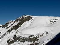 20. Peak 5861m (W face) 20. Peak 5861m (W face)5737m Looking NE from Col 5737m |  21. Noijin Kangsang (7206m) 21. Noijin Kangsang (7206m)5737m Looking N-NE from Col 5737m |
| From the Col at 5737m to the summit of Jitan Zhoma | ||
|---|---|---|
 22. Western Zhomu valley 22. Western Zhomu valley 5861m Looking N down the ascent route |  24. Reaching the summit ridge 24. Reaching the summit ridge 6000m Looking NW | 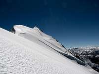 21. Noijin Kangsang (7206m) 21. Noijin Kangsang (7206m)6000m Looking S towards the summit |
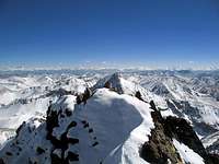
Reaching the summit ridge at an altitude of approx. 6000m, the route joins with the East Couloir. Kaluxung main and south summits are now visible to the east. The summit ridge is short (about 100m), and did not present major difficulties at the time I climbed it (November 2010), with a good snow cover facilitating a quick progression. The three small rock/snow prominences at the end of the ridge must be climbed with precaution in case of cornices over the steep east face.
| From the Col at 5737m to the summit of Jitan Zhoma | ||
|---|---|---|
 25. Junction with the East Couloir 25. Junction with the East Couloir6000m Looking SE, with Kaluxung in the background |  26. Summit ridge 26. Summit ridge 6000m Looking S, with the summit in the background |  27. On the Summit 27. On the Summit 6026m (GPS) Vestiges of a previous ascent |
 28. Summit ofJitanzhoma (map 6004m, GPS 6026m) 28. Summit ofJitanzhoma (map 6004m, GPS 6026m)with the Bhutanese Himalaya in the background |
4. When to climb / Route condition
The route can be climbed all year round, but it is better to avoid the monsoon season (summer) when the whole area is prone to sudden weather change, and the lower part of the route may be prone to avalanches. Winter is a very nice season to climb in Tibet, but the cold is pungent and winds can be extremely fierce, especially towards the end of the winter.The route conditions can vary significantly. According to my experience, the summit ridge will have a thicker snow cover in the post-monsoon season, covering all tricky rocky sections. The following two pictures show the summit in March 2008 and November 2010.
 March 2008 March 2008 |  November 2010 November 2010 |
5. Essential Gear
Camping equipment, crampons, ice axe and appropriate clothing for a 6000er are essentials.6. Map
 Extract from the Noijin Kangsang map, with the different route options to join Jitan Zhoma NW face marked in red
7. Note on the altitude
According to the 1:50'000 Noijin Kangsang map, the summit of Jitan Zhoma has an elevation of 6004m. Corax Jitanzhoma page gives an altitude of 6028m measured with GPS. During the four ascents I made on 6 and 7 November 2010, my own GPS readings on the summit were 6026m / 6019m / 6017m / 6026m (average 6022m). It is therefore reasonable to consider that the map is underestimating the true altitude of around 20m, the elevation of Jitan Zhoma being somewhere between 6015 and 6030m.8. GPS Waypoints
From the starting point on the roadside to the junction at P5281m
Option A: East (left) side of the valley
P4830m: Lat 28°54'09.39"N Lon 90°07'27.95"E Starting point on the road side (road marker Km 126)
P5042m: Lat 28°53'38.66"N Lon 90°07'34.04"E Waypoint (good views on Jitan Zhoma from that point)
P5280m: Lat 28°52'43.98"N Lon 90°07'50.55"E Junction for Camp 5404m and Camp 5377m
Option B: West (right) side of the valley
P4830m: Lat 28°54'04.97"N Lon 90°07'20.33"E Starting point on the road side (road marker Km 126)
P5084m: Lat 28°53'28.45"N Lon 90° 7'34.44"E Nomadic camp (Jitan Zhoma is visible to the south)
P5117m: Lat 28°53'19.42"N Lon 90°07'39.37"E Waypoint (Jitan Zhoma is visible to the south)
P5280m: Lat 28°52'43.98"N Lon 90°07'50.55"E Junction for Camp 5404m and Camp 5377m
From the junction at P5281m to the col at 5737m
Option A1: East (left) side of the valley – following Jitan Zhoma North glacier
P5404m: Lat 28°52'23.08"N Lon 90°08'11.77"E Campsite (good views on Jitan Zhoma North face)
P5451m: Lat 28°52'13.72"N Lon 90°08'10.49"E Start of snowfield
P5481m: Lat 28°52'08.96"N Lon 90°08'11.60"E Start of glacier
P5645m: Lat 28°51'54.91"N Lon 90°08'03.82"E Waypoint on the glacier
P5737m: Lat 28°51'52.35"N Lon 90°07'57.56"E Col 5737m
Option A2: East (left) side of the valley – following the snowfields below P5776m
P5404m: Lat 28°52'23.08"N Lon 90°08'11.77"E Campsite (good views on Jitan Zhoma North face)
P5451m: Lat 28°52'13.72"N Lon 90°08'10.49"E Start of snowfield
P5521m: Lat 28°52'05.33"N Lon 90°08'4.69"E At the foot of the big serac on the edge of the glacier
P5737m: Lat 28°51'52.35"N Lon 90°07'57.56"E Col 5737m
Option B: West (right) side of the valley
P5377m: Lat 28°52'20.65"N Lon 90°07'46.96"E Campsite
P5490m: Lat 28°52'02.10"N Lon 90°07'38.44"E Start of snowfield (put crampons)
P5737m: Lat 28°51'52.35"N Lon 90°07'57.56"E Col 5737m
From the col at 5737m to the summit
P5737m: Lat 28°51'52.35"N Lon 90°07'57.56"E Col 5737m
P6000m: Lat 28°51'40.95"N Lon 90°08'08.26"E Point where the eastern route reaches the summit ridge
P6026m: Lat 28°51'39.64"N Lon 90°08'08.61"E Foresummit
P6026m: Lat 28°51'39.03"N Lon 90°08'08.21"E Summit of Jitan Zhoma
9. Labelled Panorama
 South (Bhutan Himalaya) South (Bhutan Himalaya) | 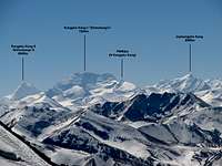 South (Bhutan Himalaya) South (Bhutan Himalaya) |  South (Bhutan Himalaya) South (Bhutan Himalaya) |
 South (Bhutan Himalaya) South (Bhutan Himalaya) |  South - Southeast (Bhutan Himalaya) South - Southeast (Bhutan Himalaya) |  Southeast (Karjiang & Kula Kangri) Southeast (Karjiang & Kula Kangri) |
 North North | 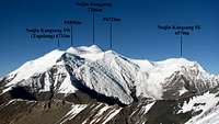 North – Northeast North – Northeast |
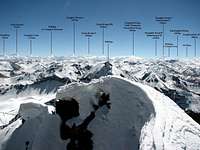
10. Other panoramic views during the climb and from the summit
 Jitan Zhoma Jitan Zhoma |  Jitan Zhoma Jitan Zhoma |  P5776m P5776m |  P5776m) P5776m) |  Kaluxung Kaluxung |  Kaluxung Kaluxung |
 Kaluxung Kaluxung |  Kaluxung Kaluxung |  Gyalongsum Gyalongsum |  Gyalongsum Gyalongsum | 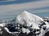 Gyalongsum Gyalongsum |  Noijin Kangsang Noijin Kangsang |
 Noijin Kangsang Noijin Kangsang |  Peak 5962m Peak 5962m |  Karjiang / Kula Kangri Karjiang / Kula Kangri |  East side East side |  East couloir East couloir |  Peak 5861m Peak 5861m |