
-
 4749 Hits
-
 77.48% Score
-
 8 Votes
|
|
Mountain/Rock |
|---|---|
|
|
43.22563°N / 4.92884°W |
|
|
Hiking, Mountaineering, Scrambling |
|
|
Spring, Summer, Fall, Winter |
|
|
6365 ft / 1940 m |
|
|
Overview
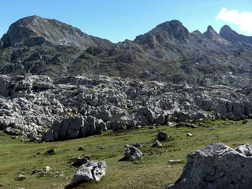
Jultayu as seen from near Refugio Vega de Ario
The Macizo El Cornion, the western massif of Picos de Europa, has in the easternmost region a wonderful viewpoint like the Mirador des Ordiales in its westernmost part: the summit of Jultayu (or Hultayu in the local language).
Like Mirador des Ordiales, Jultayu is far from belonging to the high summits of the massif; it culminates at 1940 m.
As Mirador des Ordiales, Jultayu is an equal awesome outing.
Jultayu is the easternmost summit of one of the main ridges of El Cornion, coming from Torre de la Canal Parda to La Robliza and Pico Cuvicente; the latter being the western neighbor summit of Jultayu. To the south and east Jultayu shows more than 1400 m high impressive rockfaces down to the Garganta di Cares and the village of Cain. To the north the slopes are not so steep, dropping down to Jou de Jultayu and the Vega de Ario region.
The views from Jultayu are impressive.
To the north and northwest stretches the whole highland of El Cornion massif and further on the Sierra de Cuera and the Sierra de Sueve can be seen together with the Atlantic ocean on clear days.
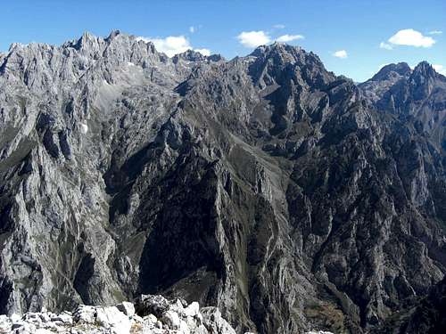
The views to the east is dominated by the Macizo Los Urielles and the nearly 2000 m high west face of Torre Ceredo.
To the south you see the Bermeja region and the Valdeon; Pena Prieta in the far south.
The western view is dominated (or blocked) by the Macizo El Cornion itself: Peña Santa de Castilla, Pico Cuvicente, La Robliza, La Verdilluenga ……
Jultayu is a long but easy day hike, which can be combined with a traverse from or to Pico Cuvicente. The nearby Refugio Vega de Ario (or Refugio Marques de Villaviciosa) invites for drinks, food and even an overnight stay.
Getting There
near Refugio Vega de Ario
There are two main trailheads for Jultayu:
- You reach Lago de la Ercina
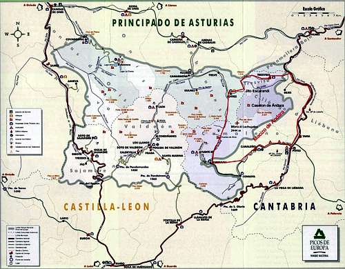
At Soto de Cangas take AS 262 to Covadonga.
In high season (july and august)and during some high days road number CO-4 is closed for public traffic from about 8 am to 8 pm. During this time you have to take shuttle busses to Lago de Ercina, starting at Cangas de Onis and several other stops between that town and Covadonga. You can use the public ALSA busses or private taxi busses. All information about the close-downs and the busses can be found here. Outside the close-down hours you can drive up by your own car.
During the rest of the year it is allowed to go up to Lago de la Ercina by car. ALSA busses and taxi busses are operating notwithstanding.
![Jultayu]()
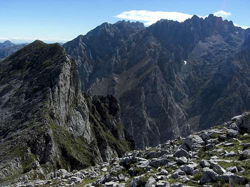
Torre Ceredo west face above Garganta de Cares as seen from Jultayu
There are two parking areas near Lago de la Ercina:
The ALSA busses end at the Buferrera parking area; the taxi busses go to the Restaurante Maria Rosa!
As a climb of Jultayu isn´t a very short outing I recommend to drive up by car before the high season daily close-down of the road and wait for the reopening in the evening. As the food at the lakeside restaurants seems to be not bad, the evening waiting time should be not too boring!
- You reach Cain, coming from Burgos or Leon region on road number N 625 to Cistierna and Riaño in the direction to Cangas de Onis.
At the Ermita del Ponton road number LE 2703 branches off to the right to Posada de Valdeon. From there take the narrow road to Cordiñanes de Valdeon and to Cain.
Main Routes Overview
Northern Route
Trailhead: Lago de la Ercina
Start at the upper parking area and cross the meadow north of Lago de la Ercina to a huge rock above the eastern shore of the lake. At this rock a trail starts (sign for “Refugio Vega de Ario) ascending to Majada La Veguina and to Jou del Beduyal. After a level part the trail arrives at Majada Las Bobias, an enchanting place with a spring with good water southeast of the Majada.
The trail traverses high above Majada La Redondiella, crosses Valle el Cabrital and a small creek and ascends more steeply to more Jous and Vegas until it arrives at El Jitu (El Hitu), a col below Cabeza La Forma and 10 minutes away from Refugio Marques de Villaviciosa.
 Lago de la Ercina, northern trailhead |  Blossoming brushes |  Northern route with Torre Ceredo |
There are two alternatives which can be combined to a round trip:
- Leave the trail at some huge cairns to the right and follow off-trail some more cairns to Horcada (Horcau) Valle, a depression between Cabeza la Forma and the Jultayu / Pico Cuvicente massif.
At that point DON´T follow the obvious line of cairns to your right; this is the route from Refugio Vega de Ario to Vega de Aliseda and Refugio de Vegaredonda! Go more or less straight on, navigating around many small sinkholes and karstic depressions until you arrive the steep meadow slopes of Los Parés, the northern limitation of the Jou de Jultayu. Climb these slopes up to Los Pares, a nice viewpoint. Take a narrow trail in a scree field to your right and traverse the lower parts of the Cuvicente east slopes until you arrive at the col between Pico Cuvicente to the west and Jultayu to the east.
Climb then the west ridge of Jultayu until it is better to stay on its left (= northern) side, passing an impressive rock window. Climb then steeply and easy (meadows and some rocks) up to the summit ridge and follow it to the summit. - Go on to the Refugio Vega de Ario. Turn right there and follow the cairns and a foot track, crossing meadows and later on many karst features until you arrive at Collada Las Cruces, where the Canal de Trea route joins the ascent route (see below). Follow the trail which winds up the north ridge of Jultayu until you arrive at the summit (cairns, some red dots).
 Northern route |  Jultayu west ridge with Macizo Los Urielles |  Rock window of west ridge |
Southern routes
Canal de Trea route
Trailhead: village of Cain at the southern end of the Garganta de Cares
For the Canal de Trea route follow the signs to the Cares gorge from Cain (Ruta de Cares), cross river Cares on Puente Los Pinteros and follow the trail to the water capture at the upper beginning of the Garganta di Cares. Follow the Ruta de Cares to Puente de los Rebecos and Puente Bolin.
After Puente Bolin look out for the sign “Canal de Trea”; a narrow path leaves the Ruta de Cares to the left and climbs steeply up the Canal de Trea to the Collada (Collau) Las Cruces. Turn left on the trail to Jultayu summit. Follow this trail easily up to the summit.
This route is, due to the heavy altitude difference, not very frequented.
 Lago de Enol |  Jultayu and Macizo Los Urielles |  Pico Cuvicente, Jou de Jultayu |
Canal de Herrera route
Trailhead: village of Cain at the southern end of the Garganta de Cares
An alternative for a round trip from an to Cain is to use the Canal de Herrera route. This includes, however, summiting Pico Cuvicente and traversing the connecting ridge between the Cuvicente and the Jultayu summit.
For the Canal de Herrera route take the road which leaves Cain at its northwestern edge and ascend that route until you reach the lower end of the Canal de Herrera.
Alternatively ascend to Cain de Arriba, cross the small village, turn right and follow the road until you meet the lower end of the Canal.
A trail starts there, ascending steeply the Canal up to Sedos de Oliseda, a rock feature where the narrow path is very steep and some rock scrambling is involved. The route goes straight up to Horcada Arenizas at the eastern border of a huge sinkhole, called El Hoon de Oliseda.
From there walk and scramble up the west ridge of the secondary summit of Pico Cuvicente, called Torre de la Celada (Adrados map) or Morra di Cuvicente. Descend into a notch and scramble up the summit west ridge of Cuvicente.
For the traverse to Jultayu follow the upper narrow part of the Cuvicente east ridge (a short and exposed UIAA grade I terrain) to broader and easier parts of the ridge. Traverse into the east slope of Cuvicente by crossing some talus and scree fields and descend the east slope until you reach the narrow trail coming up from El Jito. Turn right on that trail and follow it to the col between Cuvicente and Jultayu.
Climb then the west ridge of Jultayu until it is better to stay on its left (= northern) side, passing an impressive rock window. Climb then steeply and easy (meadows and some rocks) up to the summit ridge and follow it to the summit.
Red Tape & Accommodation
National Park boundaries
Red Tape
Jultayu is part of the Picos de Europa National Park.
The national park was set up in may 1995 by enlarging its predecessor, the "Parque Nacional de la Montaña de Covadonga" (National Park of the Covadonga Mountains). This one was founded in 1918 to mark the 12th centenary of the famous Battle of Covadonga in 718 (or 722), the ignition point for the long Spanish Reconquista, which ended in 1492 by conquering Granada.
The National Park actually includes a total of 64,660 ha. In July 2003 the Picos de Europa were made a Biosphere Reserve by UNESCO.
The entrance to the national park is free, you need no permits.
Jultayu and Macizo Los Urielles
There are the following regulations for the park:
- Generally respect the nature settings of the park and its cultural and natural values.
- Respect all plants, animals and minerals, don´t collect / disturb them.
- Use mainly the trails, roads or cairned routes for your outings in the National Park
- Take your waste out of the park.
- No fires within the park boundaries.
- No fishing and hunting within the park.
- Follow the advices of the National Park staff.
- Free camping is not allowed within the park. Bivouac is allowed in zones above 1.600 m from one hour before sunset until one hour after sunrise.
- No bathing in the lakes and creeks within the park.
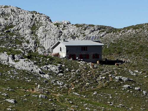
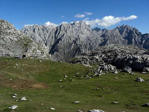
Refugio Vega de Ario
Accommodation
You find accomodation at:
Mountain hut:
Refugio Marques de Villaviciosa, also called Refugio Vega de Ario (closed during winter), food and lodging.
Gear & Mountain Condition
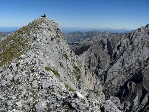
Jultayu summit
Jultayu is mainly a spring, summer and autumn hike.
In winter the mountain is surely a snow shoe tour, too.
The Adrados map shows no ski tour routes in this part of Macizo El Cornion. The north route to Jultayu has – in my opinion – too much ups and downs for a nice downhill ride. The Canal de Trea or Canal de Herrera are very steep and seem to have not enough snow most time of the winter / early spring.
You need normal hiking gear for a summer and autumn tour on Jultayu. Gaiters and hiking poles may be useful in springtime.
The summit ridges of Cuvicente and the traverse to Jultayu has scrambling and short climbing parts up to UIAA grade I (see Canal de Herrera route).
In winter and early spring you need full snow shoe gear and avalanche protection.
A Spanish avalanche bulletin for the Picos de Europa (Boletin de Peligro de Aludes) can be seen here.
Current Weather for Cangas de Onis:
Current weather for Cain / Posada de Valdeon
Maps & Guide Books
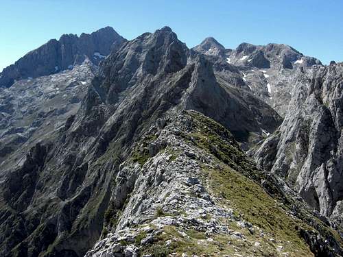
Summit ridge of Jultayu with La Robliza and Pena Santa de Castilla
Maps:
Picos De Europa , Macizo Occidental (El Cornion) MM016, Western Massif - Topographic Walking Map, scale 1 : 25.000, Adrados Editions
The best hiking map of the region I know.
Parque Nacional de Picos de Europa; 2 Mapas Excursionistas, Escala 1 : 40.000, Macizo Central y Oriental; Macizo Occidental; Editorial Alpina
A good hiking map, not too detailed but sufficient for hikers.
Standard guide book in English:
Robin Walker: Picos de Europa, Walks and Climbs, Cicerone guide
Spanish publications and more maps can be purchased in the towns and villages round the Picos.