
-
 4364 Hits
-
 78.27% Score
-
 9 Votes
|
|
Mountain/Rock |
|---|---|
|
|
46.31205°N / 13.74513°E |
|
|
Hiking, Skiing |
|
|
Spring, Summer, Fall, Winter |
|
|
6565 ft / 2001 m |
|
|
Overview

The Valley of Triglav Lakes from the summit of Kal

The view from the summit of Kal
Kal is another typical mountain above Komna plateau. That means: nothing very attractive about it, no high rock walls, no big altitude, much more beautiful in winter, when covered with several meters of snow, than in summer, where dense vegetation can pose a few unpleasant challenges. As the nearby Lanževica, it is very panoramic - the views over the Valley of Triglav Lakes are actually from Kal much better than from the already remote Lanževica.
Since locals abandoned the area, Kal is rarely visited. Except, as said, in times of tour skiing. In the past, on the plateau, at foothills of Kal massif, there were three alpine pastures: Poljanica, cca 1620 m, on the south, Na Kalu, cca 1600 m, on the south-east, and Lopučnica, 1560 m, on the north-east. These meadows are still nowadays connected with marked paths, but on them there is not a single solid building standing any more. The summit of Kal, those 400 m higher, is pathless, but easily reachable. Also those marked paths which go nearby and are connecting more populated places, are very rarely used. Today hardly anyone goes over Oslova škrbina from Komna on Planina Za Skalo and also over Velika Vrata from the Valley of Triglav Lakes on Planina Za Skalo. Those are remote, abandoned places.
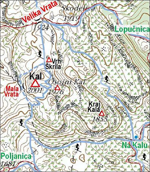
The summit of Kal has two bumps, the western one is higher. The eastern one is also called Osojni Kal, 1976 m. Towards the south-east a broad ridge descends on Lepa Komna plateau. It has characteristic rocky plates and steep rocky steps. Everything is much overgrown with dwarf pines. The last bump above Planina (meadow) Na Kalu is named Kraj Kala, 1855 m.
Getting There

Kal (left) from Dom na Komni
The most natural way to reach Komna plateau (and Kal) is from Bohinj valley. The road at the end of Bohinj finishes on the altitude of 654 m. There is a big parking place (fee) and a mountain hut. To Dom na Komni (hut, hotel, 1525 m) you will walk some 2 h 30 min and your luggage can be transported by a material cable-car.
The other possibility is from the north-west, from Vrsnik. We drive from the main Soča valley into Vrsnik, and on the place where the road ascends to the end of valley, and does a big turn left (on the southernmost point of the road), we park on some 700 m. The place is called Pod Zjabci and there the marked path on Planina Za Skalo starts.
For general orientation see the Julian Alps page.
And here is the interactive map of the broader area (Kal is just on the upper edge):
Routes Overview
Summer and winter routes go by the same directions, so they will be described here together. I will describe them in parts, first the sections by beaten paths to the high passes, and then by pathless terrain on top.

Kal from Lepa Komna
1. Komna - Poljanica
This route is in detail described on the page of Lanževica, because over Poljanica the most beautiful ski tour on Lanževica goes. So, from Dom na Komni we go west to Planina Na Kraju, there deter right (towards the NW) and ascend 100 m on a saddle, where we reach Lepa Komna plateau. Then almost horizontally over Lepa Komna towards the north-west on Poljanica. Easy summer marked path, very picturesque ski hike, 1 h 30 min.
2. Vrsnik - Mala Vrata
From the parking place in Vrsnik we follow a good, marked path, which in turns ascends in the south-east direction. Till Planina (meadow) Za Skalo, 1552 m, we need some 2 hours. There we continue over the meadow and on the first crossroads go left (the right marked path goes on Oslova škrbina), so towards Velika Vrata. After some 15 minutes, on some 1675 m, an unmarked path deters right, towards the south-east. It follows a valley, which ascends just towards Kal mountain. In the upper part the path keeps a bit right of the summit, so that it reaches the main ridge south-west of Kal. The pass is called Mala Vrata, cca 1860 m.

Kal - south tour
3. Poljanica - Kal
The summer ascent goes towards Mala Vrata and from there on top. You keep more on western slopes, because on the southern slopes there is dense vegetation. This is an easy scramble. The same direction is taken of course if you get on Mala Vrata from Vrsnik (#2 above). In winter we ascend on skis from Poljanica till below Mala Vrata. There we turn right on the southern slopes. They are getting steeper and steeper, but no serious difficulties. So we ascend on the saddle between the two summits of Kal. From the saddle we go left (westwards) on the highest point. You ski down on Poljanica by the same route. This is the usual ski tour, nice, only medium hard.
4. Skiing from Kal on Velika Vrata
This ski descent is important to those who want to do one of the most beautiful ski tours above Komna - that is the Kal - Velika Vrata - Čelo traverse. On Velika Vrata pass you can get from Komna also by other directions, but the route over Kal summit is nice and often used. It is not just easy, because the descent from Kal summit is steep and intermitted with rocks. From the summit you first ski down on the saddle between the two Kal summits, and there turn left. At first only the descent is fine, then it gets steep. You keep right (eastwards) and so avoid a rocky step below. When you are over the steepest part, the continuation is easier. You reach the broad main ridge and continue northwards. The ridge bump Vrh Škrila, 1947 m, is usually detoured by the left (western) side. Then you slide down to the saddle. In summer, this can be also the route of ascent on Kal (in the opposite direction).
5. Western ski detour of Kal summit
If you are coming on a ski tour from Poljanica, and you don't want to ascend Kal summit, you can detour it by the western side. In that case you continue on Mala Vrata and descend from that saddle towards the north-west. But only some 25 meters. Then you use a ledge which brings you in an ascent aroud Kal on the main ridge behind Kal. From the distance the traverse looks steep and exposed and as it is west oriented, early in a day the snow on it can be hard. Please add more information if you have experience of this traverse!

Karst formations on the route to Velika Vrata
6. From the Valley of Triglav Lakes on Velika Vrata
This is the marked path, connecting this valley with Planina Za Skalo. From the hut we go over a ridge towards the west (towards Komna). After reaching the ridge, we descend in a few turns some 100 meters, and soon reach Lopučnica meadow, 1535 m. There the marked path to Komna turns towards the south, but our route on Velika Vrata deters right, towards the north-west. We ascend in turns through nice larch woods, detour the summit of Brinje, 1820 m, by the northern side and soon reach out of woods. Over an interesting high karst the path goes a bit left, in the western direction. Soon we reach Velika Vrata, 1924 m. 2 h from the hut, easy path. Then on Kal as described in #4.
7. From Planina Za Skalo to Velika Vrata
We ascend first from Vrsnik parking place to the alpine meadow Za Skalo (2 h), and there continue towards the east-northeast. Instead of deterring right on Mala Vrata (as on tour #2), we continue over the more and more open terrain and soon comfortably reach the pass. 1 more hour from the meadow. Then on Kal as described in #4.

Masterpiece art of Nature
8. Brinje ski passage
Pertaining again more to the ski tour on Čelo, but passing through Kal massif is also a passage, which brings you from Na Kalu (meadow) directly on Velika Vrata. Mostly people ski down there, after doing the traverse Kal - Čelo. So, coming on Na Kalu from Komna (see the page of Komna for description - you follow the ski marks from Dom Na Komni towards Triglav Lakes), you notice a distinct valley, continuing in the north-western direction. It passes Kraj Kala summit and ascends on the high plateau, called Na Brinju. Continuing in the same (NW) direction, the passage brings you just below Velika Vrata pass.
When to Ascend?
Kal can be ascended any month of a season. Unless combining the ascent with other goals, summer tours can be a bit boring, even if the landscape around is very nice. But times of tour skiing are the best to ascend the summit of Kal. This can be from somewhere in january, till May. The ascent from Komna goes by the southern slopes, which are soon ready. The descent from Kal northwardsm requires good conditions, because slopes are steep.
Huts and Camping
1. Koča pri Triglavskih jezerih, 1685 m.
2. Dom na Komni, 1520 m, (04) 5721475, (050) 611221,
3. Koča pod Bogatinom, 1513 m, (04) 5723213, (050) 621943.