
-
 8528 Hits
-
 76.66% Score
-
 7 Votes
|
|
Route |
|---|---|
|
|
41.33003°N / 122.63557°W |
|
|
Hiking, Scrambling |
|
|
Summer, Fall |
|
|
Overview
 Mount Shasta and Mount Eddy from Cory Peak
Kangaroo Lake comes as a bit of a revelation after driving up from the high desert valley of the East Fork of the Scott River. After climbing through the ponderosa and fir trees, the road suddenly ends at the lake, a glimmering sapphire gem set amidst pink and gray cliffs. While the lake receives its fair share of attention, considering how remote it is, most who come here are anglers. The exceptional scenery just above the lake is generally ignored and few venture to the other excellent destinations in the region. Most of those who pass by the other side of the mountain are thru-hikers on the Pacific Crest Trail (PCT). For those who wish to go beyond the cool waters of Kangaroo Lake, a host of destinations await. Chief among them are the summit of Cory Peak, with exceptional views of most of the Northstate, as well as Bull Lake and Robbers Meadow. Be prepared to have the area to oneself, aside from an occasional traveler on the PCT.
Route Description
 The small unnamed lake below Cory Peak
The Kangaroo Fen Trail was designed to connect Kangaroo Lake to the PCT. The trailhead is located just down the road from the campground parking lot. It is marked with an obvious sign. Even though the trail switchbacks constantly, it is still a fairly steep climb, rising over 500 feet in about 0.5 miles. The trail crosses many small creeks. The carnivorous Darlingtonia are common along this stretch of the trail. The trail initially angles away from the lake then arcs back toward it midway up the climb. A faint use-trail goes out to a rocky ledge for one of the best views of Kangaroo Lake. The route again angles away from the lake as it continues to switchback upward. Eventually it turns back to the east, toward the lake, as it nears the crest of the Scott Mountains. This final traverse just below the crest often holds snow into July. One on the crest the views are excellent. The trail continues east, now descending gradually down toward the PCT. While numerous pines and firs were found on the north side of the crest, the descent is through a craggy area with lots of oddly colored rocks. After dropping only 100 feet in 0.3 miles the Kangaroo Fen Trail ends at a junction with the PCT.
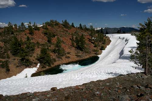
 Cory Peak and the small unnamed lake
From the junction of the Kangaroo Fen Trail and the PCT, there are numerous options one can exercise. While it is possible to head west on the PCT, this is not an attractive option since there are no interesting destinations for 6.5 miles and those are more easily accessed from the PCT crossing at Scott Mountain Summit on Highway 3. Instead, destinations to the east include a pair of unnamed lakes, Robbers Meadow, Bull Lake and Cory Peak. All destinations can be reached via the PCT except the mountain and it can be climbed from three different points on the trail. These options will be addressed in order that they are encountered on the trail.
Scott Mountains Crest Route
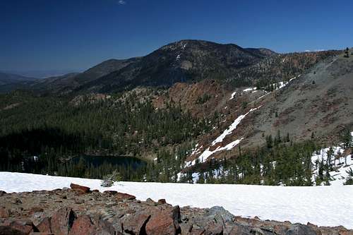 South China Mountain and Rock Fence Lake from the Scott Mountain crest
The first option for climbing Cory Peak is to follow the Scott Mountains crest, leaving the PCT almost immediately after having reached it from the Kangaroo Fen Trail. This route offers the best and most consistent views of any of the routes up Cory Peak. It also lacks water. This is easily the hardest route to the summit, though it is not particularly difficult. The crest climbs moderately at first. The trees disappear after a few hundred yards and one is left with seemingly alpine terrain for the duration of the trip. Despite appearances, the route is not above tree line. Rather the lack of trees is testimony to the incredibly poor soil that is typical of these mountains. While the crest seems to have an obvious summit, this is not the summit of Cory Peak. Instead of climbing all the way to the top, after about 0.75 miles up the crest after leaving the PCT, depart from the crest to the right. Traverse the south side of the false summit. While doing so, the true summit of Cory Peak comes into view. The northern side of the false summit is not a good route because of the exposure above the Rock Fence Lake basin. Beyond the false summit, the route to Cory Peak is obvious. Cross the saddle that separates the two points and simply climb up the rocky slopes to the summit. If one follows this route, it is worth continuing beyond the summit to the south side of the peak to visit the small lake tucked into a crater below the summit.
Robbers Meadow Route
 Robbers Meadow
This is the easiest route to the summit of Cory Peak. Rather than following the crest, stay on the PCT. The trail heads southwest. Below the PCT one can make out a small lake and some meadows. Opposite the small basin is Peak 7,087. It stands out due to it’s being composed of greenstone, a vaguely granite-like rock. Most of this area is made up of the aforementioned serpentine and peridotite. Beyond the saddle the separates the Scott crest from Peak 7.087 the trial enters the large basin containing Robbers Meadow, an attractive patchwork of lush grassy areas. Though the trail never passes through the meadow, staying high above it, the sounding of the creeks flowing through it are audible. On the far side of the basin, the trail crosses a large boulder field. It is at this point that one deviates from the PCT and begins to climb toward the summit of Cory Peak.
Ascend the boulder field, heading east. One can usually hear water rushing beneath the rocks as it drains down toward Robbers Meadow. The grade is moderate and the boulder hoping is a nice change of pace. After 0.4 miles one reaches to top of the boulder field. Cory Peak looms just to the north. Before climbing it, head south just a couple dozen yards for a chance to gaze down on Bull Lake, the upper Trinity River Canyon and the dramatic west face of Mount Eddy. From here, it is possible to simply traverse the flank of Cory Peak toward the summit, which is on the north side of the mountain. Instead, climb the shoulder just above the top of the boulder field. About 150 feet up the shoulder levels out and there is a surprisingly attractive turquoise lake in nestled in a bright red, rocky bowl. To reach the summit from the lake, continue to traverse the west face of the mountain to its northern side, gradually climbing as one proceeds. Once on the north side it is a very short scramble to the summit.
Bull Lake Route
 Mount Eddy and Bull Lake
From the boulder field above Robbers Meadow, continue on the PCT for about a mile. A short distance from the boulder field, the trail rounds a sharp corner and a decent sized lake comes into view below the trail. Beyond the turn, the trail continues east to Bull Lake, a 12-acre body of water. The basin containing the lake is surprisingly barren. To reach Cory Peak from Bull Lake, climb the slope to the north of the peak, ultimately reaching the aforementioned vantage point that looks down on the lake. Continue up to the small lake below the Cory Peak and onward to the summit.
Suggested Loop Option
It is obvious that a loop can be completed while climbing Cory Peak. If this is the intent, the best option is to follow the PCT to Robbers Meadow or Bull Lake and to climb up to the unnamed lake from there, then proceeding on to the summit. Return via the Scott Mountains crest. This allows for an easy ascent up the boulder field above the meadow or from Bull Lake, rather than a steeper more constant climb up the crest. Plus, the best views from the crest are to the west, which are easily appreciated while making ones way downhill.
Map
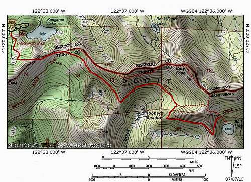 Kangaroo Fen Trail and the PCT