
-
 11697 Hits
-
 88.19% Score
-
 26 Votes
|
|
Mountain/Rock |
|---|---|
|
|
35.29838°N / 24.11739°E |
|
|
Hiking, Mountaineering, Scrambling |
|
|
Spring, Summer, Fall, Winter |
|
|
7277 ft / 2218 m |
|
|
Overview
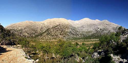 Kastro above the Oripedia Niatos Plain Kastro above the Oripedia Niatos Plain |
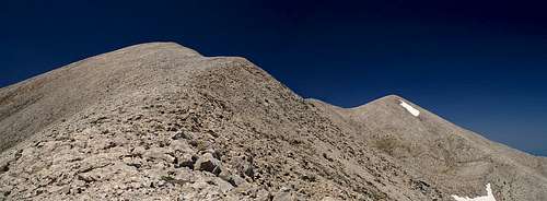
Καστρο, (latin: Kastro) is the easternmost 2000er of the Levka Ori Range on Crete. It is a barren, three peaked summit. But wait a minute - peak is not the right word as all three summits are rather round-topped. But if you are counting on an easy climb - forget about it fast.
While being the easternmost 2000er, Kastro is still quite far away from civilization. The closest you can get is the village of Ammoudari in the west of the Askifou plain, which can be easily reached via the Chora Skafion road from the north and south of the island. However, Ammoudari is located 1600m below Kastro and some 10km to the east of its main summit so that climbing the mountain is a serious undertaking. You can cheat, however, by driving from Ammoudari along a narrow mountain road towards the Tavri Hut. The road, while paved at first turns into a dirt and gravel road and leads to one of the Cretan high plains at about 1100m. But even from here a day tour to Kastro and back will strain your strength and stamina.
Above 1200m or 1300m you have to climb through a rocky limestone desert. And even though the mountain looks easy from afar, its slopes and ridges are very steep - at least in places. The general (or normal) route follows the east ridge of the northernmost summit. The ridge is part of the European long distance trekking trail E4, for which marking posts have been planted. However, these posts are placed rather far apart so that they can only serve as pointers for the general direction. Until you reach this east ridge orientation can be difficult in spite of the posts but once on the ridge this difficulty vanishes. You still have to fight against the steepness of the ridge, though.
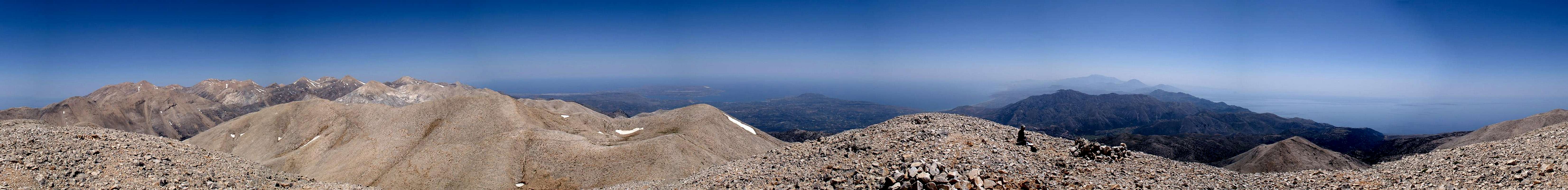
Thanks to its position in the east of the range, Kastro is a wonderful lookout peak, maybe even surpassing Cret's highest mountain, Psiloritis. You have fine views towards said Psiloritis in the east and towards the south and north coasts. What is really fabulous, however is the close-up view into the Levka Ori Range itself, the white limestone desert with its 60 2000ers. From this vantage point it is evident that the alpine part of the E4 trekking trail, which runs through here is as serious as trekking can get.
As for the descent, there is a second route, which follows the east ridge of the central (and main) summit. It is without any mark or track, however, and requires a good path-finding sense. If you have that, the route becomes evident: first along the east ridge until a southern ridge joins, then along this south ridge to a saddle and from the saddle through a wild, rocky and sometimes overgrown valley to the high plateau near the Tavri Hut.
Kastro should be a perfect ski tour destination in winter.
|


360° Summit Panorama
  |
Getting There
 The Akrotiri Peninsula with Chania's airport
From Chania in the north of Crete, follow highway E75 east in direction of Rethymno and Heraklion, until you reach the exit Vrysses. Right in the centre of the small town the road to Chora Skafion turns off to the left (south). Follow it all the way until you reach the Askifou Plain. After a long stretched left hand curve turn right into the village of Ammoudari. If you want to cheat by following the mountain road further turn right almost at the end of the village. There are no signs and you may have to ask for the Tavri Hut.
The mountain road runs northwards until it reaches a radio antenna, from which it is about 1km until you reach the high plateau. There is a little chapel near which you can park your car. The Tavri hut is located a little to the south-wet of the road.
|


Red Tape
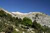
 The Kastro eastern slopes
I'm not aware of any red tape in this part of the Levka Ori. However, the area is used for sheep and goat grazing and you might run across shepards herding their flocks from one place to another. Naturally you should give them the right of way.
Accommodation
 The Levka Ori stone desert
You can quite easily find hotel rooms and apartments everywhere on the coasts. All European travel companies offer accommodation so a visit to your nearest travel office will find you some. The closest possible accommodation can be found at Ammoudari and at Askifou, but also at Imbros and Asi Gonia - the villages of the Askifou plain. Of course there also is the Tavri Hut, which is located at the start of the climb but I don't have any information about its opening times. In May, when we climbed the mountain, the hut was still closed.
Weather Conditions
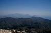
 The Kastro Summits from the north ridge
The weather sites on the web only carry information for the cities on the north coast, which are 2000m lower than the mountain top of Kastro. Consequently temperatures will be lower by some 15° C on the summit. Also, especially in winter and spring, the White Mountains are covered in clouds while the coast is clear. On a day like this don't venture in the range - orientation is difficult enough without clouds. The enarest weather link I could find was at Souda near Chania on the north coast of the island, some 40km to the north:
Maps & Books
There are quite a number of maps and books out there, which deal with the island of Crete and naturally I don’t know them all. This is the list of maps and books which I used and I appreciate it very much if you can add to itMaps
Unfortunately there are no topographic maps of Crete. The best maps I could find are scaled 1:100000 and contain the main hiking routes on the island. In one case the map showed wrong paths and roads (exchanged them) but in general they were quite useful.
- Kreta / Crete / ΚΡΗΤΗ Western Part
Touring Map
1:100000
Harms Verlag
ISBN: 3-927468-16-9
Books
Since there are no good topographical maps of Crete you should take care to get a good guidebook. The ones I used have good tour suggestions though the descriptions often are somewhat shortish. In one case the maps were wrong but since the above map also showed wrong paths (as well as other maps I saw later) I attribute this to a general problem with the cartography of this specific area. Moreover, the books were issued in 2002 and thus paths might have changed meanwhile. The books are available in German and English. The description for Kastro was excellent, however. It was barely understandable as we prepared the climb but when seeing what the description talked about it was 100% correct.
- Kreta West / Crete West
Gert Hirner / Jakob Murböck (translation: Gill Round)
Rother Verlag
ISBN:
3-7633-4221-4 (German)
3-7633-4803-9 (English)
boutin - Jun 19, 2008 10:13 am - Hasn't voted
Anavasi MapsThere are now excellent 1:25000 maps of lefka ori (Anavasi, both paper & electronic). With a gps the're fine additions. I would say the easiest & fastest way is not along ridges (following the E4), but and according to the Loraine guide (the white mountains, cicerone new edition this summer) to take a 280° west bearing from the plateau directly into a reentrant. It is not waymarked but there are some cairns, a bit of scrambling at places. Instructions in the guide are clear enough.
Gangolf Haub - Jun 19, 2008 11:00 am - Hasn't voted
Re: Anavasi MapsThanks for the info. I think the route you are referring sounds like my Central eastern ridge route. It is certainly the shortest route to the summit but I wouldn't call it the easiest one. But maybe I misinterpret your comment ...
boutin - Jun 20, 2008 2:47 pm - Hasn't voted
Re: Anavasi MapsHi, it's the route with some rock scrambling needed at the beginning and also a bit later on, and the one described in Loraine Wilson's guide. Easiest? well there'no path but other routes are longer and terrain is not easier in my opinion. Anyway, I'm looking for info, all kind of tips, on the Livada to Niato E4 stage. Any chance you did that one? Regards
Gangolf Haub - Jun 21, 2008 6:20 am - Hasn't voted
Re: Anavasi MapsI'm afraid not. I happened to hike parts of E4 but always with some close objective in mind (like Melindaou, Kastro, Psiloritis). So I don't have any info on your stage. Also, information about E4 is rare on the web. Good luck anyway!