Prologue
With Ryan just recovering from surgery, and myself getting the beginnings of a bad flu, we logically decided the time was right for a mid-technical route on Rainier. That was how our Kautz attempt began, it ended with a 21 hour summit day that left both of us on the brink of collapse and most of my gear covered with snot, phlegm, blood, and grit.
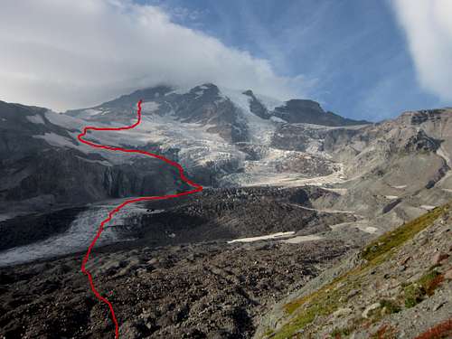
This was actually my second attempt on the route, the first being in July of this year, when we turned around just below the ice chute. Reports of high winds near the summit, a slab building up in the chute itself, and our leader’s nervousness about descending the ice pitches, conspired to turn our climb into a reconnaissance effort. For which it actually served quite well, as a knowledge of the route up to that point proved very helpful. Our plan remained basically the same as in July - set a base camp near Hazard and then climb to the summit and descend via the Disappointment Cleaver route, but what we did not know was this:
http://mountrainierconditions.blogspot.com/2012/04/disappointment-cleaver-2012.html
IMG effectively closed off the route just hours before we were to descend it.
Additional photos can be found
HereThe Approach
Day 1: Paradise the Lower Wilson
Our plan was for a two and a half day climb, on Friday afternoon we would drive down to Paradise and try to get across the Nisqually, then on Saturday we would hike up to Camp Hazard and on Sunday we would make our summit attempt. Earlier in the year one can hike as far as the shiv before dropping down onto the Nisqually but to avoid the heavily crevassed areas we only went as far as Glacier Vista before descending steeply to the glacier. Some maneuvering was necessary to get around the crevasses but nothing too circuitous.
![Lower Nisqually]()
On our map the route to the Wilson was marked to the left (west) of the waterfall, and a group we met descending said something about a gully, but unless this was in reference to the large scree valley east of the cliff band we couldn’t find anything viable and instead went up the scree and black ice slopes (a moderate snow climb in July) to the lower Wilson plateau, where we camped for the night. Shortly after we arrived we realized how dangerous our route had been, as we saw massive rock and ice fall (chunks the size of mobile homes) channeled through the gully we had just climbed up. Although convenient because of how safe it made our camp site, it was the first in a series of realizations that turning around was not a viable option.
Day 2: Lower Wilson to Camp Hazard
From our camp on the lower Wilson we got a late start and ascended to the top of the Turtle ice-field by mid-afternoon. Until about noon mist frequently obscured our views but the route was direct enough that it was not really a problem. Knowing that we had more than enough daylight to reach our high camp, we killed some time top-roping crevasse walls on the upper part of the Wilson. Although fun, it was not exactly ice climbing as about half of each pitch consisted of a heavy, wet snow that made pick placements release unexpectedly.
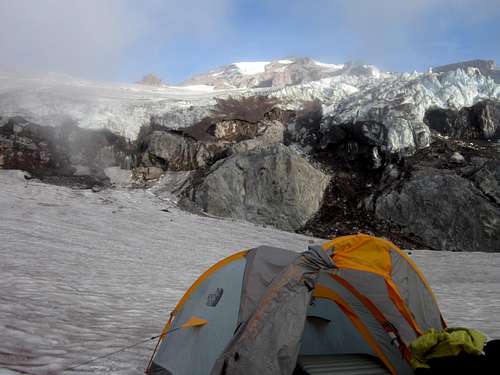
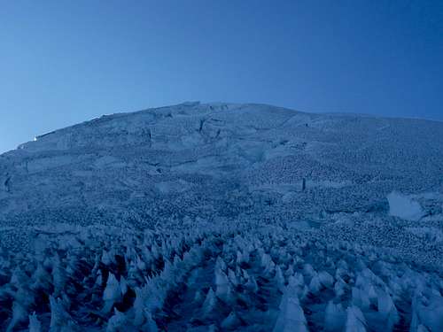
The Turtle was, as we then considered it, heavily sun-cupped and progress was frustratingly slow, leading us to select one of the first campsites at its peak, at around 10,000 feet. By this time we were above the mist layers but a strong wind had picked up, with gusts strong enough to blow one off balance.
After setting up the tent we decided take as much of our gear as possible up the rock step, both to check out the route and to save us time and effort the next day. About forty-five minutes and some aimless wandering brought us to the rappel point, where we found a fixed line that seemed to be in satisfactory shape and a crevice where we could stash our rope, harnesses, crampons, ice-tools, and screws. The wind by this time had become truly awful and we descended quickly hoping the gusts had not been as strong at our camp. Whether they were or not we’ll never know, but at soon as we caught sight of the tent we knew something was deeply wrong; at first it seemed to have partially blown over but then we realized that it was about a hundred feet from where we had set it up, right on the edge of where the Wapowety Cleaver drops down onto the lower Kautz. Inside it was our sleeping bags, pads, and most of our extra clothing and only that weight must have kept it from sailing out over the cliff. Bearing in mind that all four corners and two guy-lines had been secured with rocks before, we only left camp one at a time from that point on.
![Hazard-ish]()
The near-disaster with the tent put both of us on edge, so we decided to simply melt the water we would need for our summit push and then go to bed. About nine or so the wind died down and we managed to get a few hours of sleep.
The Climb
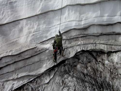
With some idea of what was ahead of us, we woke at 12:45 and were moving toward the rock step by 1:30. The wind had not started up again and the night felt strangely warm, in addition to being brightly lit by the nearly full moon. After rappelling down the fixed lines we encountered the first sketchy shit-show of the day: the chutes on either side of the main Kautz ice-chute end at headwalls, which means that, unlike the Kautz ice-chute, they regularly send down debris. The point of leaving at mid-night was to avoid this sort of objective danger but as the night was so warm there was little we could have done. A couple minutes before we cross the section we witnessed a small volley of perhaps PC-sized ice chunks come down. All we could do was observe how broken the grown was and deduce that it would not be too difficult to dive for cover if we heard anything, hope a major ice avalanche did not occur, and get across quickly, which we managed without incident.
![Headlamp on the Ice-Chute]()
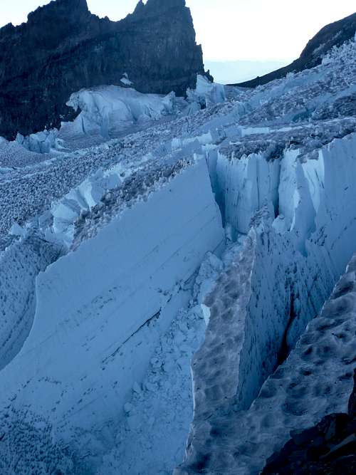
The lower slopes of the Kautz consisted mostly of deep steps, shot flat stretches ending in six to seven foot walls. This ground was not easy to move through quickly, but also not very exposed, so we simply set a running belay. Once we got the ice-chute proper we transitioned to a traditional belay with 2-3 point equalized anchor belay points and progressive protection as we ascended. I was feeling like total and complete shit so Ryan took the first lead and quickly ran out our 40 meter rope. Following was not technically difficult (maybe a WI2 with a layer of frozen mud) but strenuous, especially on the calves. Pick placements nearly always sounded hollow and getting one I was actually confident of took 4-5 swings in most places, yet the slope was moderate enough that for long stretches I didn’t bother too much with it and just trusted my feet. Feeling like we were in too deep to complain, I took the second lead and ended up about 10 feet short of an excellent natural shelf, leaving me with a hanging belay. Ryan led another pitch and then during my second lead we toped out of the ice chute and the slope angle dropped to where we only needed a running belay. First light was around this time.
![The Upper Kautz]()
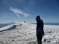
From the top of the ice chute to the summit was a long traverse around the upper slopes of the Kautz, Nisqually, and Ingraham glaciers, as we attempted, in vain it often seemed, to find our way through the maze of crevasses; I do not exaggerate when I say that what we saw there was about two-dozen of the largest, scariest, most beautifully menacing crevasses I have ever seen, dwarfing anything in the North Cascades. Eventually we met the beaten path of the DC route about 100 feet short of the crater rim and finally summited at 11:45. I probably would have been content to sit in a wind-sheltered spot for a few more minutes but Ryan, this being his first summit of Rainier, was intent on reaching the true high-point at Colombia Crest, so we made our way across the crater and up to the windblown summit itself.
The Descent
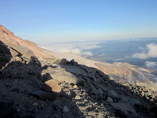
The route down the mountain appeared to be a veritable road, so we set out confident that we would be in Camp Muir before long and back to Paradise at a reasonable time. Despite our state of exhaustion, the summit push had taken more than ten hours, we proceeded at a decent pace until the track disappeared in a patch of ice. We followed a series of broken flags down for a few hundred more feet, but by this time we could look across and up at the Disappointment Cleaver and we couldn’t seem to find any way across down the cliff to the faint tracks that led back up. Based on our limited knowledge of the route, it was clear that we were much too far north (Camp Schurman would have been a more direct shot than Muir), but as we had come from the south-west there was no way we had been on the wrong route from the beginning. This left us with two options, the first was to descend farther and hope we picked up the route again, the second was to go back up and hope we missed a fork in the trail. I was very confident that I had not missed a junction, so we descended for a few more minutes before it became increasingly clear that there was not a way down and south to the DC. This left us with only one option - re-climb the route and hope we had missed something, meanwhile knowing that if we had not our only choice would be to descend the Kautz, bivouac somewhere along the way, and likely have the park service out looking for us on Monday.
![Upper DC Route Late Season]()
Luckily, we found a faint side-trail (really just a trench) at around 13,400 ft that contained a scattered collection of flags. The footpath had clearly gone off to the left, which is why I had not really noted it as a junction, but it was in the correct position for a straight shot down to the DC. Predictably, the not-track disappeared fairly quickly, but by this time we were desperate and willing to force the route. In other conditions this would have involved a rappel or two but with the slopes so heavily sun-cupped it was simple enough down climbing we didn’t even need to set a running belay and soon, much to our relief, we found ourselves at the top of the DC with a clear track down.
![Lower Ingraham]()
The true difficulties were over. The route wandered over the DC and we followed it roughly, snow and scree and crampon scraped rock. Crossing the Ingraham we had to get creative again but we always re-met the defined route after each detour (it seems likely that these were the areas where the guide services use a ladder). Just as darkness was catching us we arrived at Camp Muir and, for the first time in 16 hours, took off our crampons. Running on sheer adrenaline, I was so drained that whenever I stopped for more than a minute or two I started shaking uncontrollably, despite it not being very cold.
The muir snowfield has never felt so long, or the trails to the parking lot so aimless or wandering. There was a point where we realized that we not on the trail we had used coming up, but observing that this is probably the only place on earth where all roads lead to paradise, we didn’t worry about it too much and finally hiked at around 10:30 pm, 21 hours after we left our camp that morning.
Evaluation
It now seems clear what happened: the IMG group cleaned the route behind them, removing fixed lines and ladders, this explains why our route, so clear on minute, seemed to disappear into thin air. Had we spoken to climbing rangers on Friday when we got our permits this might have been avoided but this time of year that ranger station is only open on weekends.
This route proved to be the most serious, strenuous, committing climb either Ryan or myself had done. Although generally not considered a highly technical route, with both the glacier and ourselves in decidedly bad condition, it was a real challenge.
Sometimes in the winter and spring, clad in fresh snow, Rainier can appear luminous. Glowing magnificently in the moonlight, the very air sparkling in the afternoon sun. But by autumn the pretty sheath has melted and away and we see the mountain’s true nature. Driving away, looking back at the mountain, Ryan and I agreed she looked positively murderous.
Hail Talol, mother of snows; and hail the jewel of the lotus flower.


Comments
Post a Comment