
|
|
Route |
|---|---|
|
|
37.96170°N / 116.4617°W |
|
|
Spring, Summer, Fall |
|
|
Overview
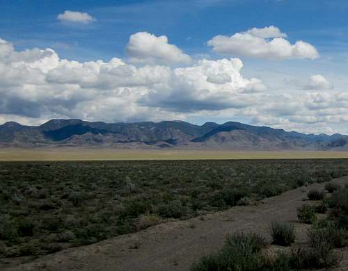
Kawich range
While many have used the eastern approach as described by streeyr on his summitpost page, there is another option to be found and that is from the west via Haws Canyon. Bob Sumner sought to find a better route from the west and was the first, that I know of, that used the Haws Canyon approach. It was thanks to a trip report provided by Andy Martin that helped Dennis Poulin and myself to find our way to the top of this brushy beast. That report by Andy Martin can be found HERE and is worth checking out.
Kawich Peak is among the Nevada peaks that very very few would ever repeat due to the brush that protects the summit from interlopers like myself. John Vitz stated that of the 250 peaks he had climbed in Nevada, Kawich Peak was his least favorite. He even went so far as stating that this mountain "sucks". He had used the eastern approach. I think that after doing it from the west and reading another report put up by Adam Helman, that the Haws Canyon approach might be the better way to go.
Getting There
Getting ThereLeaving US 6 (38.1497 116.5789), about 36 miles east of Tonopah, head south on the signed Silver Bow/Golden Arrow road which we found to be a good graded dirt road. After about 4 miles on this road, we took a lesser road (38.0976 1166083), that headed toward the Kawich range and Haws Canyon. From the turn off at US 6 to where we ended up parking at the wilderness boundary, the distance was roughly 17 miles. Our route to Haws Canyon was different than what Andy Martin used but both his route in and ours came together at 37.9926 116.6728 (elev 6550). All waypoints listed here are in lat/long nad 27. From there we continued to another junction where we took a right (37.9841 116.5155) and found our way to a meadow where Andy Martin noted he had parked and utilized as his trailhead due to the wet conditions of the meadow (37.9684 116.4930 elev 7100'). We found the meadow dry enough to continue on to the wilderness boundary where we car camped and used as our starting point the next day (37.9589 116.4877 elev 7300').
At the time of our visit, 4 WD was not necessary while high clearance was nice to have. We crossed several spots that would have had water running them earlier in the season (see Andy Martin's report) but were dry at the time of our visit in the middle of September. Dennis Poulin had the following comments: "We picked a good time of year to climb Kawich. IT is a bit of a drive back into the Haws Canyon, but we didn't use 4WD. When we reached the big meadow, we noticed it was not muddy, so we drove across it and continued another .75 mile to the Wilderness Study Boundary sign at about 7,300 ft. This last part was kind of brushy and I added to the brush mosaic on the sides of my truck."
 On the way in, old stone cabin ruins are passed On the way in, old stone cabin ruins are passed |  Last bit before brush Last bit before brush |  Benchmark found at summit Benchmark found at summit |
Route Description

Route Map
Route Description
Both Dennis Poulin and I listed trip reports for our visit on the peakbagger.com Kawich Peak page but I will share Dennis's report here as his report also has a GPS track attached which will be of great help to those who use the technology. I have also created a map for our route that may prove helpful and will list a couple waypoints but if
you enlarge the GPS track map created by Dennis, you will have a very helpful piece of information that will be key to making this route understandable.
Dennis:
"The hike required some navigating. First we hiked a little ways up what was left of the road and then followed cow trails up the valley. Our first objective was a saddle at about 8,000 ft off to the left of the drainage we were hiking in. This is a good waypoint to have on your GPS. We hiked up to the saddle and then dropped about 40 ft into another drainage. Here we followed more cow trails up this canyon until we were below a steep gully that leads directly to the summit. This is another waypoint that is good to have on your GPS.
Hiking up this steep gully requires some route finding to avoid most of the brush and some rocky areas. Staying in the bottom of the gully worked most of the time except when it got too brushy. We made good progress all the way up to about 9,000 ft. At 9,000 ft we hit a wall of brush. This is where the bushwhacking began and it mercifully ended about 1.5 hours later when we got to the summit. This brush is mostly Mountain Mahogany. Busting our way through the brush we could see where Andy Martin and others had gone because there were broken branches. Also someone had placed pink surveyor ribbon about every 40 ft. Unfortunately we couldn't see 40 ft through the brush so we broke more branches, crawled under the brush in a couple places, and generally sought the least brushy spots to bushwhack upwards. Wow, I was glad to get to the summit. Coming down was a little easier, the pink ribbons helped as did my GPS track. This short hike took us 7 1/3 hours to complete."
Total distance round trip: 5 miles
Elevation gain (overall) 2300 feet
Time needed: For us it was a bit over 7 hours including our 40 minutes on the summit. That time is taking into consideration my age (I just move slower nowadays)
 I'm in the brush I'm in the brush |  I'm in the brush I'm in the brush |  400 feet of brush hell 400 feet of brush hell |
"I have done over 250 peaks in Nevada and this is my least
favorite. It is a relentless bushwhack from any direction.
I approached it on an ATV track off of the Eden Canyon road
southeast of point 8262. This mountain sucks."
(5 miles; 2600 elev gain).
Be prepared
If you go into this area of Nevada, be prepared with both a good vehicle and plenty of supplies such as gas, water and hopefully a second vehicle to travel with your group as a backup. It's a long way to anything and often you won't see anyone else the whole time you are there.  Brush just before the summit Brush just before the summit |