
-
 9629 Hits
-
 77.48% Score
-
 8 Votes
|
|
Route |
|---|---|
|
|
47.55000°N / 12.92000°E |
|
|
Rock climb |
|
|
A long day |
|
|
IV- |
|
|
Approach
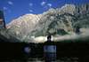
You cross the Königssee by ship to St. Bartholomä (604 m), where the Watzmann-O-Wand-Haus is situated. From here you start at about 4 or 5 a.m. and follow the marked route and way through the Eisbachvalley. In 1 h, you reach the Eiskapelle (850 m) where the Kederbacher Weg starts.
 |
Route Description
Summary
The Kederbacher Weg is a classic route through the E-face. Because of the 2 ice fields it has an alpine character. The key passage at the Schöllhornplatte is IV-, the rest III (some passages) and II or easier. The face is 2000 hm high.
Route
Over the ice field to the bergschrund (at the end), which is located about 100 m below the highest end point of the ice field.
100 m over this terrace and then up to the lumps of rocks and to the right side to the 2. terrace.
On this terrace further to the right, until you reach a big gorge (snowplace, P. 1150 m). Over the gorge to its furthest right side. From here up to the left to a big basin (beginning of a clear-cut gorge).
The beginning of the gorge is at the big basin (P. 1210 hm). You have to climb up through this gorge 70 m. At P. 1250 hm you have to turn right sharply and to continue 100 m easily going up over the lumps of rocks to the left side so that you reach the Schöllhornkar.
You have to climb up in the middle of the corrie and over the screes to the right (P. 1520 hm). After this, you have to go up the ice field right of the middle and to find a possibility to traverse to the rocks on the right side. Then you continue on a 3 m wide band.
The starting point is in the corner of the face on the left side of the 3 m wide rock band (P. 1640 hm). Attention: you must never turn right!. Then you have to climb through the wet cutting 8 m up, then 5 m horizontally to the left around the edge (bolts) and straight on up on a rock band (20 m IV-).
On this band, you go to the left side to a basin. Here is the starting point of a ramp. Go up to the right, 60 m, pass a waterfall on the right side and go straight up in the falling line of a cave, the Zellerloch.
At the Zellerloch, you go a few meters to the right to slippery shelfs, then 30 m up and directly after a clear-cut crevice to the left around a round rock pillar. Here begins the 3. band.
You go to a big basin (snowplace) and up to the ridge spur (P. 1880 hm). From here, you continue to the apparent end of the rock band at a rock corner (Kaserereck).
From the topmost corner, you turn (exposed to the left) around a rock edge and then 20 m a little bit down. You continue in the same direction slightly up and turn around at the topmost end of the 3. band to the left side to an outstanding brown tower which you leave on the left side. On the right side of this tower, you climb up in crumbling rock and further to the left up to a ridge edge. This is the beginning of the summit gorge.
 |
Essential Gear
Crampons and 1 ice axe are necessary for the ice fields!!! Rope and slings for the rock climbing.