Keg Mountain
It had been a good month since I had done Boulter Peak and I was getting out of shape despite a few minor hikes in the previous thirty days. It was time to put together a good weekend effort as I had three full days to play for once. The remainder of the time had been taken up with going home to Kennewick every weekend to try and get a house ready to sell and to move and pack up thirty years of accumulated stuff. So having a weekend to just hike and explore was just what the doctor ordered. My first peak would be a lonely place in the west utah desert but after having done little for a month, it would be in my eyes, a Utah treat.
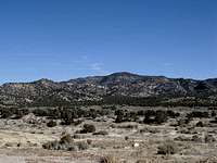
I had been wanting to get back out into the Utah desert and my eyes were set on a lonely peak that is truly in the middle of nowhere. That peak was the high point of the Keg Mountain range and of course is known as Keg Mountain. Since I have described how to get there on the Keg Mountain page, I will avoid repeating that information here and would refer that section to you should you ever become interested in hiking this one.
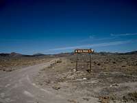
Once I was a few miles past Little Sahara, the pavement turned to dirt and that was the way it would remain for the next 35 miles. I would call it "high speed" dirt as I could do 40 mph nicely the majority of the way to the turn off that led me into the heart of the Keg Mountain range.
![The road heads]()
![Keg Pass, 5 miles ahead]()
The turn off was a good 40 miles from U.S.6 and I had studied the topo's and noted that there was a road listed as a jeep road a few miles up the road before Keg Pass. The turn off immediately became a lesser quality road but not bad enough that it would stop a passenger vehicle for a mile or so. After that mile, it becomes more of a high clearance road but one that never really requires 4WD. It turned out that I was able to drive the jeep road further than I figured and the six mile hike I had planned on turned out to be less than half that distance. I followed the jeep road as far as I could and then when the jeep road turned south, I parked and started my hike. I proceeded northeast cross country and saw no sign of any kind of a trail. However, using my topo and GPS, I was able to establish a good route up to a ridge that came down towards me.
![Route map]()
I followed the ridge up towards the peak and for the most part it was straightforward walking, mainly class one and two. The fascinating aspect of this hike was the rock itself in many places. The rock was pockmarked and in some places took the appearance of goblins and evil looking faces. I wouldn't want to do that area at night as I might get a bit spooked by
the sinister looking countryside as provided by those rocks and rock faces. As I got closer to the mountain, the last portion of the hike steepened and made me work to find a decent cross country route that allowed me to reach the summit ridgeline.
While there was nothing really difficult, the fact that there is absolutely no one out in this area made me very cautious in foot placement as a broken ankle or leg would be serious business in this out of the way place. When by yourself a long way from help, it pays to pay attention to detail and not do anything stupid since most people think that people who hike by themselves are already a bit on the stupid side.
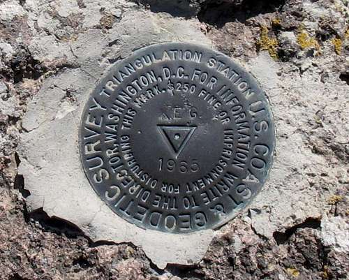
After zigzagging my way up the steep portion, I finally found the slope opening up to where I could see the rounded summit ridge line not far above me. It was here where I began to see a foot print or two in a few spots but they were pretty old from the looks of them. As I came over the top, I saw some rocks piled up to form a small cairn and a benchmark was nearby. Also a register was nestled in the cairn but it was getting in pretty bad shape and I kicked myself for not bringing up a register container and a book and pen for future visitors to this remote spot.
Before I spent any time at the high spot, I walked the ridge to the northern end and was surprised to find so many trees present. Views from the north end looked far into the Utah desert and you almost feel like you are on a desert island of the ocean variety. After wandering back to my daypack and snacks, I browsed through the register that was placed by John Vitz a few years earlier. Since his visit, there had only been just a few visitors, about one a year on average. The most recent visitor was our own
SP member, gjagiels
After contemplating the beauty of the desert views I had and eating my snacks, I attempted a cell phone contact but with no success. A digital cell phone just won't cut it out in this area as the towers are too far away. I had a cell phone with analog capabilities that never failed me but
I no longer had that cell phone to aid me in a remote place like this one.
Looking at my watch, it was time to head back down and head back home. Tomorrow I would find another peak to hike. This wasn't all that much of a workout hike wise but it was a long drive to get there and back.
3.2 miles and 1300 feet of elevation gain. If I were to do this one again, I'd combine it with Drum Mtn or Indian Peaks.
One last note: I didn't see another person all day until I was back close to Little Sahara and the friday night campers were headed that way. I'd suggest have everything in your vehicle that you would need in case you had a breakdown. It can be mighty lonely out there.
The next day I went on to do Champlin Peak followed by Mt. Ogden and then Black Crook Peak. Then it was back to the "move" and another month of inactivity.


Comments
Post a Comment