
-
 28250 Hits
-
 84.82% Score
-
 19 Votes
|
|
Mountain/Rock |
|---|---|
|
|
46.50776°N / 13.95234°E |
|
|
Mountaineering, Trad Climbing, Scrambling, Skiing |
|
|
Spring, Summer, Fall |
|
|
7030 ft / 2143 m |
|
|
Overview
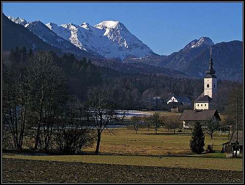
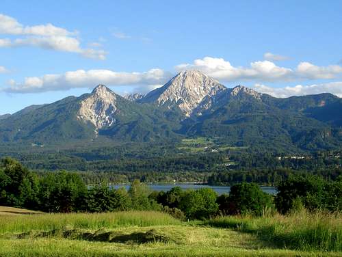 Herb - Kepa / Mittagskofel from the north
What's New Here?
> Jan 28th, 2021: Interactive map-guidebook embedded.
> Jan 17th, 2019: Design corrections
> Sep 8th, 2014: Minor changes, Gubno/Huehnerkogel info added.
> Oct 8th, 2004: The route over NE ridge mentioned.
> Juy 15th, 2004: Initial setup of the page.
Slovenian Characters
When reading Slovenian words on maps or in books, you will find special characters for ch, sh, and zh. They are written with c, s and z with a caron - little v above them (čšž).
Overview
After Stol / Hochstuhl and Vrtača / Wertatscha, Kepa / Mittagskogel is the third highest mountain in the Karawanks range. Due to its beauty it is a true landmark of Kaernten (Austria), from where it is seen like a regular rocky pyramid with a bit cut off peak, so when having clouds around the summit, one could easily think of looking at volcano. Of course it is built of limestone, as other summits of Karawanks.
It is quite different from the southern, Slovenian side. Hiding behind forehills, the summit can be seen only from a distance, from the plane around Bled, and from one spot in the Upper Sava valley, close to Belca village. Of course, if we climb a bit higher, let's say in Julian Alps, the summit is seen as a beautiful high mountain.
The broader area has the following summits: NW of the main summit is the 1815 m high Koroška Mala Kepa, then the main summit comes, 2143 m, NE of it is at the end of the NE summit ridge also a cross on the fore-summit. The first summit towards the SE is Dovška Mala Kepa, 2077 m, then Gubno / Huehnerkogel, 2034 m, then the ridge of Plevelniki comes. The highest summit in this one is Visoki Kurjek / Baerenkogel, 1973 m, east of it is Lepa Plevelnica, 1959 m. Towards the southwest from Gubno a side ridge goes down. It is names Kurjeki, 1888 m, 1666 m. Finally, north of Kepa, above Bertahuette, there's a nice summit of Ferlacher Spitze / Komnica, 1742 m. It offers a fine view over the whole northern side of the main ridge.
Ascents on Kepa / Mittagskogel vary from a medium difficult hike, over a difficult hike with some exposed and with pegs and cables protected details, to a few easy rock climbs in the north face (up to UIAA degree III). Although steep on all sides, towards the northeast Kepa / Mittagskogel has a nice ravine, appropriate also for a medium hard ski tour.
 Kepa massif from the E, from Dovska Baba Kepa massif from the E, from Dovska Baba |
 From the South From the South |
 From the West From the West |
Gubno / Huehnerkogel, 2034 m
 The view towards Kepa/Mittagskogel
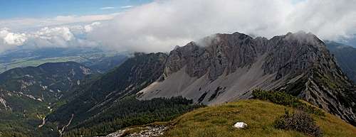 The view towards Plevelniki
Gubno / Huehnerkogel, is a grassy pyramid in the main SE ridge of Kepa / Mittagskogel. It is rising in the middle of the highest part of the ridge, SE of Dovška Mala Kepa and NW of the sharp Visoki Kurjek. On the NE side a high, very lonesome valley lies. Its slopes are rising just to the main ridge, so from the ridge it is easy to descend on the Austrian side. It's a peaceful corner of the Karawanks range, especially nice are the screes north of Visoki Kurjek / Baerenkogel. The prominence of Gubno / Huehnerkogel is only small. Towards the NW the nearby saddle is only some 60 m lower, towards the SE, the saddle towards Visoki Kurjek / Baerenkogel lies on some 1850 m. The summit is easily reached, because the marked path from Mlinca valley on Kepa crosses its slopes. The path reaches to only some 10 minutes below the summit, from there, by the easy, short S-SW ridge we can gain the summit by a tiny, not marked path. Because after the slopes of Gubno / Huehnerkogel the path on Kepa / Mittagskogel goes over two more difficult, quite exposed passages, this summit can be a substitute goal for those who for any reason don't decide to continue on Kepa / Mittagskogel. Most of the panorama is similar, but the NW and W part is being obscured by the summit massif of Kepa.
The Southern Fore-hills
In the southern forehills, although the world is rugged, overgrown with dense vegetation and mostly steep and rocky, you can still find some hiking objectives. Let's mention a few options:
- The summit of Planica, 1508 m. From the Lower Šija saddle, 1349 m, towards the west on top. Panorama.
- The summit of Borovje, 1476 m. From Vrše meadow, 1184 m towards the east directly up or from the Lower Šija saddle, 1349 m, towards the south-east. Panorama.
- Kloma gorge. From 'Tromostovje', point 1065 m, east of Borovje, reachable by car, then by an unmarked trail into Žakelj creek valley and northwards through the gorge with a waterfall on alpine meadows.
- Jerca gorge. By the mountain road around the west side of Planica, then by a hunters path down into Jerca gorge. Then right (eastwards) upstream to a 10 meters high waterfall. Then back to the hunters path and a bit more down to the mouth of Sušica creek. Then upwards by Sušica (northwards) till two nice waterfalls - the lower one is 25 m high, the upper one 15 m high (but difficult to reach). Back by the same route.
Geology
The highest parts of Kepa / Mittagskogel massif (and also the ridge eastwards to Plevelniki) is made of late Triassic (Norian, Rhaetian) Dachstein limestone and some dolomite. That explains its brittle and rugged nature. Lower parts of those mountains are made of a bit older Triassic limestones and dolomites, of Carnian - Ladinian age on the south and Carnian - Ladinian (Schlern dolomite) - Anisian age on the north.
Summit Panorama
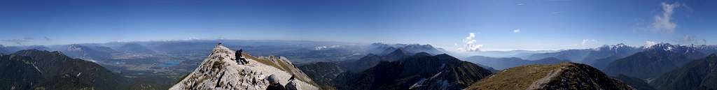
The summit view from Kepa / Mittagskogel is magnificent: Beyond Sava valley, Julian Alps are like on a parade, further towards the West Dolomites can be seen, then Grossglockner and neighbourhood, on the north Dachstein, towards the north-east to Zirbitzkogel and towards the south-east a big portion of green, hilly Slovenia.
 The view on Martuljek group The view on Martuljek group |
 Faaker See / Basko jezero Faaker See / Basko jezero |
 Eastern views Eastern views |
Getting There
For general overview information see the Karawanks GROUP page.
From the south (Slovenia), trailheads on Kepa / Mittagskogel start in Sava valley, in villages Belca, 691 m and Dovje, 704 m. From these villages forest roads go into the narrow Belca valley (you can drive only a short part, then closed for public traffic) and from Dovje also only a short part up.
From the north (Kaernten, Austria), we have some more choices. The villages north of Kepa / Mittagskogel can be reached by local roads on which we can get from the highway Villach - Karawanks tunnel. From these villages we can on foot or even by car reach both mountain huts north of Kepa / Mittagskogel. In July 2006 the mountain road towards Bertahuette was closed on the altitude of some 1180 m (a big enough parking place).
Maps:
- Kranjska Gora (community tourist map), 1:30.000 (only for south, east and west approaches)
- On-line map in German is on: http://www.austrianmap.at/.
- My U-Map (OpenStreet) below is a guidebook and enough detailed online map at the same time.
Routes Overview
From the South1. From Dovje, through Mlinca valley. 4 hours to the summit, marked, medium difficult walk up and in some places exposed ferrata sections (for experienced). T4. 2. From Dovje, over Kurjeke. 4 hours to the summit. Not marked, difficult to find hunters trail, some scramble. T4. 
3. From Belca, through Belca valley. 4 hours to the summit, marked, medium difficult walk up. T3. 4. Over Planina Belca. We drive into Belca valley, but near the confluence of Jerca creek (it comes from the east) we cross Belca creek and ascend by the lower part of Kepa SW side ridge to Planina Belca (meadow). From there we continue upwards and when the SW ridge of Kepa becomes rocky, the unmarked trail leads us below the ridge towards the right. Above, the trail is lost but we try to gain the ridge again and then in scramble and easy climbing (UIAA I) follow it towards the summit. 4 h, not marked, only for experienced! T5. |
From the North
5. From Bertahuette, 1567 m. 2 hours to the summit. The marked route goes through the NE ravine, steep walk-up (T3/T2), in winter and spring also a ski tour. The easiest approach. Bertahuette can be reached by various paths: From the north portal of Karawanks tunnel (marked), from Koča nad Arihovo pečjo (hut), 1084 m, from Spodnje Dobje / Unteraichwald (marked) by the road and on foot 1 h 15 min more, etc.
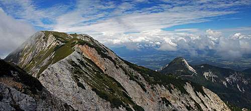
 The NNE ridge
6. From Bertahuette over the NE ridge. This is the most beautiful 'normal' ascent on Kepa/Mittagskogel. It is marked, and where the ridge allows the path, it is well beaten. But the ascent is not protected, the most difficult stretch in the beginning requires climbing of around UIAA II difficulty, later it's UIAA I. The route can be combined with the descent by the route #5.
7. From the NE, from near Finkenstein. It's a marked route, easy till the main ridge, where it joins the route #3 (from Belca valley). By very good skiers it's done also as a ski tour,
The long range of Karawanks offers of course a great possibility to hike all along the range in an east-west direction or the opposite one. In this case the route #1 is reached from the east, from Planina Dovška Rožca or Dovška Baba, and over Mlinca saddle. Coming from the west, the route #3 is reached by not marked trails, following the main ridge from Črni vrh / Schwarzkogel, 1751 m and Kresišče, 1839 m.
Climbs in the North face
Although north face is rocky, there are not many possibilities for climbing and some relatively easy routes were done decades ago.
- North-north-east ridge, UIAA I-II, 1 h 30 min.
- North ridge, UIAA III, 2 h, first ascent Auer, Kollnitz, Raditschnigg & Wegener, 1926.
Red Tape
No limitations. For Karawanks tunnel you must pay toll.
When To Climb
 Autumn shot
 A. Gospić - Late afternoon on Kepa
Kepa / Mittagskogel can best be climbed in early summer (flowers), from July to October (stable weather, clear views) and in good conditions also from February to May doing a ski tour (or a classical winter ascent). With an appropriate winter equipment the summit can be reached also in hard winter, the easyest route is the above mentioned #5.
Camping
In valleys there are camping places, but you will need some kind of transfer anyway to reach trailheads. North of Kepa there are two mountain huts:
- Bertahuette, 1567 m. Open from mid June to end of September. Tel 0664/5968677.
- Koča (=hut) nad Arihovo pečjo, 1084 m.
Mountain Conditions
For weather see here.