
|
|
Mountain/Rock |
|---|---|
|
|
47.50714°N / 11.04688°E |
|
|
Hiking |
|
|
6512 ft / 1985 m |
|
|
Overview
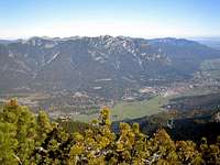 Kramerspitz seen from Osterfelderkopf.
It is purely a hiking mountain. But with some undulations, (one quite large), on the Eastern approach to the summit adding to the day's efforts, it does provide a full and very worthwhile day out from a starting point at around 700m, in Garmisch-Partenkirchen.
The Ammergauer Alpen have little of the commercialisation of the mountains directly to the South where cable cars, a cog wheel railway, and multiple huttes and winter ski lifts have encroached upon the landscape. So the Kramerspitz, like many of it's neighbours, can be a pleasant and quiet experience, with just the huttes at St Martin, (Grasberg) to the East and at Stepberg-Alm to the West. Both some way down from the summit.
Quite rightly the hike on this mountain is well known for the wonderful views it offers.
Getting There
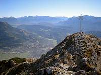
 Jubiläumsgrat seen from near the Kramerspitz saddle.
From München Airport catch the S1 or S8 mass transit system trains into the main station, and that takes about forty minutes. From there an hourly service on the main German rail system runs to Garmisch-Partenkirchen from early until late. With a half hourly service in the peak hours. Journey time around ninety minutes.
Within the town there is an excellent local bus service, (see under links), with a fixed price of 1.30 Euros, (from 2007) for each journey. Pay the driver as you join the bus. Buses run out to Farchant and also to the cable car station for the Kreuzeck and Alpspitzbahns. If you are staying in a hotel in the town itself you pay a small resort tax direct to your hotel, and amongst other things you get for this your hotel may give you a card entitling you to free journeys on the towns local buses. But note this does not cover the Regional buses run by the RVO company, or the buses to Eibsee. And also note that the town buses leave from stops both sides of the street on the East side of the railway station, (a few yards North of the station), and NOT from the bus station outside the station that is used by the RVO buses.
The RVO buses, (link below) give a good service to a number of locations away from Garmisch-Partenkirchen and can be very useful for someone wanting to explore the mountains in a wider area.
Red Tape
There is no real "red tape" for the routes to the Kramerspitz.But like all mainly undeveloped Alpine areas it is always best to leave as little sign that you have been there as possible. Disturb nothing, leave nothing behind and take only photos. That maybe describes what virtually all of us who walk in such places do as a normal routine.
Camping
The general rule for the area so far as camping away from any organised facility is, "Bivouacking tolerated, camping discouraged".When to Climb
 Summit
Local advice has been not to to attempt the mountain in winter because of significant avalanche risks higher up, especially on the steep North facing slopes that have to be crossed when climbing from the East.
Where to Stay
Garmisch-Partenkirchen has a very wide range of places to stay. From the simplest of bed and breakfast accommodation in Gasthofs up to large, (and expensive) hotels! The tourist Information service has an online system for you to find accommodation in your price range, (see links).If you prefer staying in a village local to the town, many of those also have a good range of accommodation: usually cheaper than in the town! A GOOGLE search under the village name will show those that have their own village websites. And many of these sites will also an accommodation list.
Maps
 Summit viewed from the North.
It is covered by the Bayerisches Landesvermessungsamt München Topographische Karte 1.25000 series. The two needed to fully cover the Kramerspitz are No. 8432, Oberammergau. And No. 8532/8632 Garmisch-Partenkirchen.
These maps do not seem to be widely available, but they can usually be found at buchhandlung ADAM in the Am Kurpark street in the Garmisch, (West), side of Garmisch-Partenkirchen. See under links for their web site which includes an online map to show where they are, plus online ordering. As these maps are not always available it would be a good idea to first E mail the shop to make absolutely certain they do have a copy in stock before ordering.
The route is also coverered by two Kompass maps. Kompass WK 5 Wettersteingebirge-Zugspitzgebiet 1:50.000 ISBN: 3-85491-007-X (6,95 Euro). Thanks to Sebastian Hamm for that information. And also Kompass No.790, Garmisch-Partenkirchen Mittenwald 1:30.000. ISBN 3-85491-581-0
Useful Links
Garmisch-Partenkirchen's tourist information siteEnglish version.
Where to Stay
The town's own on line system that helps you to find overnight accommodation.
Local Town Bus Timetables:
All on down loadable PDF files
RVO Bus Timetables
This link should get you to the Garmisch-Partenkirchen page. In the center click on the box in the center, (under the box with "Garmisch-Partenkirchen" in it. This has the words, "Bitte Fahrplan auswählen" in it. That then gives you a choice of the routes to click on. Following which a down loadable pdf file gives the timetable for the route.
Train Times
Use this to get timetable information for your journey by German Railways, (DB). This link takes you to an English language page.
Weather forecast
I've found this to be quite a reliable weather forecasting service
Webcam
And to see the actual weather have a look at the Jubiläumsgrat and other mountains immediately South of the Kramerspitze by viewing this webcam.
Weather data
Read the actual weather data for Garmisch-Partenkirchen.
Local maps
This Garmisch-Partenkirchen shop, (only ten minutes walk from the main railway station), keeps a good stock of guide books and general tourist type maps, plus the DAV, (German Alpine Club), maps and just a few of the elusive Topographische Karte 1.25000 maps that cover areas not included in the DAV series. Including the routes up the Kramerspitz, (see maps below).
Avalanches
Details of avalanche levels is displayed by this site in the winter months.