
-
 14995 Hits
-
 0% Score
-
 0 Votes
|
|
Route |
|---|---|
|
|
36.55000°N / 4.927°W |
|
|
Walk with some Scramble |
|
|
Half a day |
|
|
Walk-up |
|
|
Approach
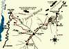
“Istán” Route (NW slope): This route begins at the upper part of the mountain village of Istán, at aprox. 360 meters high and ascends over the, firstly, NW slopes and, later, W ridge of the ‘Cerro del Lastonar’ (1.275 mtrs). From that point it joins the normal route, which starts from the ‘Refugio del Juanar’. Both routes follow the final approach to ‘La Concha’ peak over the beautiful North-NE ridge. This route from Istán is harder than the normal route: 855 height meters in approximately 3 hours for a normal walker. The more experienced walker will do it in 2 hours and 15 minutes.
The start point is the hotel ‘Altos de Istán’, a big building at the upper slopes of the village, some meters away from the start point of the mountain road to the small village of Monda. Behind the hotel starts a dusty road up towards some hills and some rocky peaks which reaches the village of Ojén (route PR-A 167 Ojén, 4 hours). Few meters walking on this road starts, to the right, a walking path to the south which shortly traverses the west flank of the mountain before going up and in zigzag to the SE. It is very difficult to miss because there is a signpost, which can be seen even from the hotel site, that shows the way to ‘El Picacho’ up and to the left (PR-A 139, 1 hour), and to the right (south) to ‘La Concha’ (PR-A 135 La Concha, 3 h 30’). All these signposts mark yellow & white routes. We have to follow the PR-A 135 to ‘La Concha’.
Route Description
After the short traverse which easily ascends over the west flank, the path takes a more direct approach, becomes stepper and climbs in zigzag till a more flatter part where another post with the yellow-white mark can be found. From there the way begins to ascend again direction to some rock formations but, at certain moment, it bears towards a small saddle with a very small rocky top to the right. To our left the heights of the NW slopes. This saddle is about 685 meters high. From here on a long and well marked path that borders along the SW slopes of the big NW ridge of the mountain. These slopes are a continuity of ridges and gullies, all of them with a WE bearing. The path to the last, and deeper, gully lets us see (up on the face of the NW ridge) the remains of the accident of a helicopter that crashed against the mountain in 2004.
Left behind the last gully, we ascend again till a height of 960 meters, where there is a small col. We reached the W ridge of ‘Cerro Lastonar’. Here the path is much less obvious but there are plenty of stone-marks pointing a climb up through the rocks and bushes. The way up is messy and requires some hand-work here and there. Near the final North-NE ridge the path is flatter but still unclear. The silhouette of the ‘mailbox’ on the North-NE ridge can be used as a mark point to reach this ridge. From there a walk over the ridge will bring us to the 1.215 meters’ point.
My first ascend to La Concha, in 1998, was over the entire NW ridge. Somewhere after have been entering the path up into the mountain and before this begins to bear towards the first saddle we will try to climb straight up towards some boulders up on the obvious ridge. From there, a long walk of more than three hours for an experienced walker reaches ‘Cerro Lastonar’ and then the North-NE ridge. I remember that most of the walk was over the S side of the ridge, and only at the upper part went on the less steeper N side.
 |
Essential Gear
Standar hiking gear. In summer sunglasses, suncream and protection for the head (cap,..). Long pants are recommended too. Plenty of water (more than 1 liter is recommended) is necessary in summer.
In winter I advise some warm clothes, even if it is just not to get cold on the summit. It can be windy up there.
Miscellaneous Info
If you have information about this route that doesn't pertain to any of the other sections, please add it here.