
-
 4378 Hits
-
 71.06% Score
-
 1 Votes
|
|
Route |
|---|---|
|
|
29.27689°N / 13.51112°W |
|
|
Hiking |
|
|
Spring, Summer, Fall, Winter |
|
|
Most of a day |
|
|
Hike |
|
|
Overview
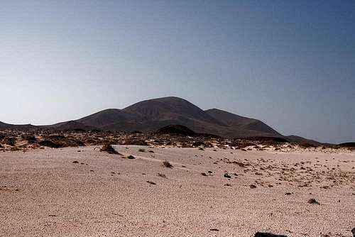
 Montaña Bermeja above the dirt track from Caleta del Sebo Montaña Bermeja above the dirt track from Caleta del Sebo |
Within the five and a half hours the regular hiking visitor to the island of La Graciosa has between arrival of the first and departure of the last ferry of the day there are three things he can do: loop the northern half of the island, loop the southern half and climb the island's highpoint Agujas Grandes. With a bit of speed you can combine any of the loops with the climb of Agujjas Grandes but you will find yourself jogging back to the harbour if you do. All routes start at the harbour of Caleta del Sebo
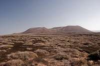
La Graciosa is a flat desert island so that you won't find any obstacles on this loop hike. The highest point is Montaña Bermeja at the northern turning point, the summit of which can be reached by a steep but still comfortable hike. Orientation is quite another issue. Though the island is flat and you can see approximately where you'll have to go, at the northern end of the island all trails vanish. Hiking through the desert sand is not much fun - you should keep close to the coast where the sand is wet. The second half of the loop runs along a dirt road making orientation real easy again.
La Graciosa is hot and dry - there is no shadow. Don't go on hot summer days - rather wait for days with lots of wind. Take big amounts of water.
Getting There
 Agujas Chicas, Agujas Grandes as seen from La Graciosa's north coast
See the main page for the itinerary info. In brief:
- Fly to Lanzarote
- Take LZ1 to Orzola in the north
- Take the ferry to Caleta del Sebo on La Graciosa. The route starts at the harbour
Route Description
 Montaña Bermeja as seen from Playa Lambra
- Start altitude: 0m
- Summit altitude: 152m
- Prevailing exposure: South during the ascent
- Type: Hike
- Protection: None
The main problem of this route is orientation and getting out of Caleta del Sebo can be the first challenge. From the harbour you can't directly follow the coastline, so instead head out in parrallel to the coast in northward direction. If you pick the right road you'll get to a raised boardwalk, which passes the village in its west. Enter that boardwalk and follow it to its end in the north of the village. There a narrow path heads back to the coast. Follow it - you will soon reach a steep part of the coast, along which the track keeps climbing up and down. After a while you'll see the summer village of Pedro Barba, the first destination of the loop, which you'll reach after about 90 minutes.
 Basalt bridges near Bahia de las Majapalomas
Follow the dock of the village and head out the other (northern) side along the road, which connects it in a wide circle with Caleta del Sebo. After ten minutes, at an intersection, turn right and head across Lomo del Burro. Here all tracks vanish and the best you can do is follow the coastline directly or in parallel a few hundred metres inland. You'll have to cross a patch of desert, stewn with dry bushes. Take the direction of the northern tip of Isla de Alegranza across the sea, which will take you to Playa Lamba a wide beach on the north coast of La Graciosa. Here you'll find the end of a dirt road - the return ticket to Caleta del Sebo.
 |  |  |
At an intersection a few steps after you leave the beach, follow the right track, which will lead you to Baya de las Mayapalomas, where you can find a channel crossed by several basalt bridges, remainders of the Montaña Bermeja eruption. At high tide the sea rushes up that channel in fast sweeps, creating big fountains at its end.
Return to the intersection and turn southward, passing Montaña Bermeja on its eastern side. Either follow the road to an intersection south of Playa de las Conchas and take the road to the beach or scramble across a spur of Montaña Bermeja towards its south face. Here a path leads straight towards the summit, turning very steep in the upper section.
After enjoying the views return the south track and head back for the beach. The coast is dangerous in the north of La Graciosa so take care when planning to take a bath. Turn towards the dirt track and follow it southward. It heads for the saddle between Agujas Grandes and Montaña del Mojon, then wind down towards Caleta del Sebo. Again, head through the maze of streets until you reach the harbour.